

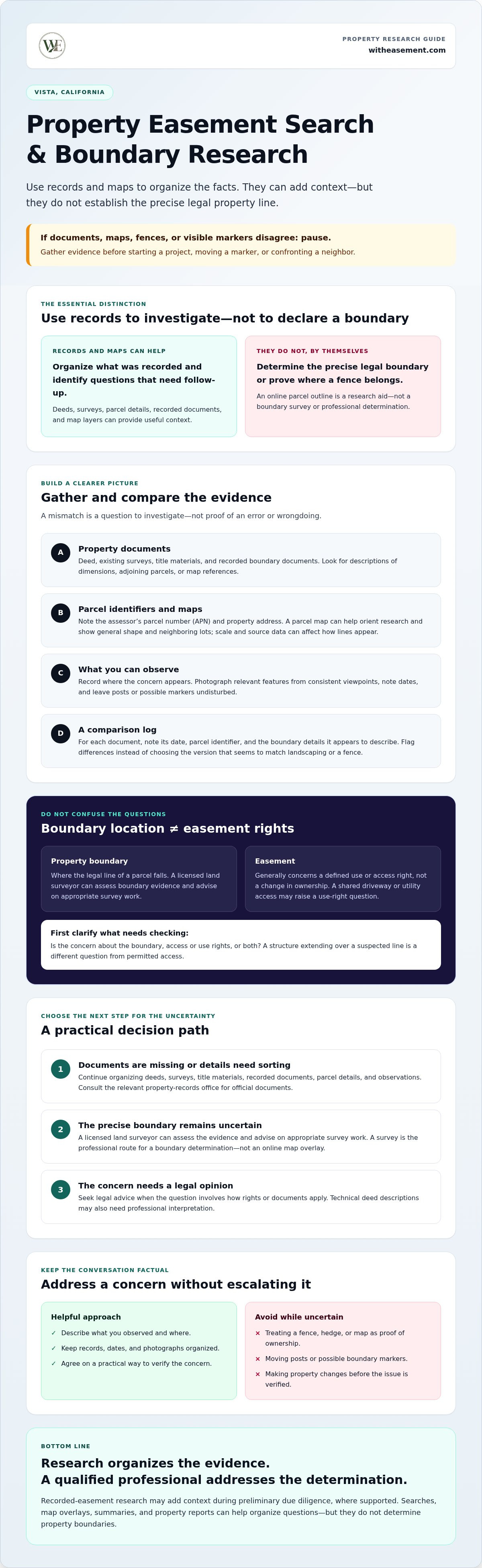
A Vista CA property easement search may help you find recorded-use information, but it won’t tell you exactly where a legal property line falls. If a fence, deed, map, or visible marker seems inconsistent, pause before starting a project or confronting a neighbor. Records and maps can help you organize the evidence, but they are not a professional boundary determination.
Start by reviewing your deed and any available surveys or parcel maps, then compare them with what you can observe on the property. Public records may clarify what was recorded, but they may not establish the precise boundary or explain how an easement applies.
This guide explains what to check first, how to raise a concern calmly, and when a licensed land surveyor or attorney may be able to help. Use property research to organize the facts, then rely on the appropriate professional when you need a boundary determination or legal opinion.
Key Takeaways
- Use deeds, existing surveys, parcel details, and physical features to build a clearer picture of a possible boundary issue.
- Treat differences between fences, maps, and documents as questions to investigate, not proof of wrongdoing.
- Match the next step to the uncertainty: review records, consult a licensed surveyor, or seek legal advice.
- Keep neighbor discussions factual and documented, and agree on a practical way to verify the concern.
- Recorded-easement research can add context to due diligence, but it can’t determine a property boundary.
Property Line Disputes: What to Check Before Taking Action
A fence sits beyond where you expected it, a parcel map seems to show a different line, or a neighbor says part of the yard belongs to them. Before responding, clarify what you’re seeing and gather the available evidence. A property line marks the legal boundary of a parcel, but visible features and online maps alone may not establish its precise location.
An online parcel map is a research aid, not a boundary survey. A fence or hedge can offer a useful clue, but it doesn’t automatically establish ownership. Collect your deed, any existing survey, and relevant maps. Note where the concern appears, take dated photographs, and leave posts or possible markers undisturbed.
Is a fence or hedge the legal property line?
Not necessarily. A fence may have been placed for privacy or convenience, reflect an earlier layout, or follow a line that differs from the recorded boundary. That difference doesn’t by itself indicate wrongdoing. Record visible features and when you observed them. Don’t move posts or markers while the boundary remains uncertain.
Could the issue involve an easement instead?
An easement generally concerns a defined use or access right, not a change in ownership. A shared driveway or utility access may involve permitted use, while a structure extending over a suspected line raises a different question about a possible encroachment. Clarify whether the concern is about boundary location, access rights, or both. For background, see what an easement is.
Recorded-easement research may add context when access or use rights are part of the concern. Keep it separate from boundary evidence: records and map overlays can help organize questions, but they don’t determine the property line. If the distinction remains unclear, note what needs verification and consider professional review before making changes to the property.
How to Verify a Property Boundary Using Records and Survey Evidence
Build a record set before drawing conclusions. Start with the deed, then gather any existing survey, title materials, and recorded documents that describe the parcel or its boundaries. Note the assessor’s parcel number (APN) and property address so you can distinguish the lot from nearby parcels. Check dates and identifiers across documents. A mismatch may reflect a change in records or a difference in what each document was created to show, not necessarily an error.
Which property documents should you gather first?
Look for prior surveys and recorded boundary documents, as well as deed descriptions that identify dimensions, adjoining parcels, or references to a map. These descriptions can use technical language and may need professional interpretation. For official documents, consult the relevant property-records office. You can also review the official property records portal, but search options and access requirements vary by jurisdiction.
Keep a simple comparison log. Record each document’s date, parcel identifier, and the boundary details it appears to describe. Flag differences for follow-up instead of choosing the version that seems to match a fence or landscaping.
What can a parcel map or online property map tell you?
An assessor parcel map can help orient your research. It may show the parcel’s general shape, neighboring lots, and where to look for relevant records. Online map layers can also help you compare a displayed parcel outline with visible features. Scale, source data, and how layers are displayed can affect where a line appears on screen.
A parcel map helps you locate and research a property; a surveyor investigates boundary evidence and documents a professional boundary determination. Don’t treat a map overlay as proof that a fence, driveway, or structure sits on a particular side of the legal line.
Compare the documents with what you can observe on the property, but keep the distinction between a clue and a conclusion clear. Photograph relevant features from consistent viewpoints, note dates, and write down questions such as, “Does this fence follow the deed description?” Avoid adding your own boundary line to a map as if it were verified. If the records conflict, a licensed land surveyor can assess the evidence and advise on appropriate survey work.
Vista CA Property Easement Search and Boundary Research
A national property easement search can help organize recorded-easement context during preliminary due diligence, if the property is within the platform’s supported coverage. WithEasement membership includes property searches, map overlays, AI-powered summaries, and PDF property reports. These tools can help organize research, but they don’t determine boundaries. Explore recorded-easement research as a context check, then seek survey or legal guidance if the boundary remains disputed.
When to Hire a Surveyor, Seek Legal Advice, or Keep Researching
Choose the next step based on the question you need answered. Reviewing records can help you organize the facts. A licensed land surveyor can investigate and document boundary evidence. A qualified property attorney can advise on legal rights and options. These roles are different, and neither an online map nor an easement search replaces professional advice when a dispute turns on a boundary or legal interpretation.
- Keep researching when you’re collecting documents and haven’t identified a clear conflict. Note inconsistencies and questions rather than deciding which record controls.
- Contact a surveyor when records conflict, expected markers are missing, or planned work comes close to a disputed line.
- Seek legal advice when the disagreement involves contested access rights, formal claims or notices, threatened litigation, or unresolved interpretation of documents.
When does a boundary concern justify a professional survey?
A surveyor may be the right next step if a fence appears inconsistent with your deed, a marker can’t be located, or construction is planned near the suspected boundary. Before engaging someone, ask what records they’ll review, what work they propose, and what documentation or deliverables you should expect. Confirm the professional’s license, the scope of the work, and applicable requirements through authoritative sources. The precise work a surveyor can perform depends on the assignment and relevant local requirements.
Give the surveyor the deed, any prior surveys, relevant recorded documents, photographs, and a clear description of the concern. This helps define the question without treating your initial map comparison as a final boundary conclusion.
When should a property attorney review the dispute?
Consider legal advice if neighbor discussions are escalating, someone disputes access, you receive a formal claim or notice, or the meaning of a document remains contested. Easement issues can involve distinct rights and obligations. The legal education resource Easements in California offers background, but it can’t assess your specific circumstances.
Prepare a concise file before speaking with an attorney: organize deeds and other records, survey materials, dated photographs, and written communications. Stick to what you can document. Only a qualified attorney can advise you about your specific legal rights and available remedies. General research can help you prepare, but it shouldn’t be treated as legal advice or a prediction of how a dispute will be resolved.
If the evidence is still incomplete and no immediate decision is required, continue organizing records and writing down unanswered questions. If a transaction or project depends on a clear answer, get the appropriate professional involved before relying on a map or assumption.
How to Address a Property Line Dispute Without Escalating It
A calm, documented process can keep a boundary concern from turning into a larger neighbor conflict. Organize what you’ve observed, then raise the issue without presenting an unverified map or assumption as fact. The goal is to agree on how to clarify the situation, not to decide the boundary during an argument.
- Organize the evidence. Gather relevant deeds, maps, survey materials, photographs, and correspondence. Note what appears inconsistent and what still needs verification.
- Contact your neighbor calmly. Describe the specific feature or location that prompted your concern. Ask to compare information and discuss a reasonable way to confirm the facts.
- Compare documents carefully. Share relevant records, but explain when a map is only a preliminary reference and not a boundary determination.
- Agree on a next step. If the evidence doesn’t resolve the question, consider whether a qualified surveyor or, if legal rights are disputed, an attorney should help.
Pause construction, excavation, or changes near the disputed area until the relevant facts are clearer. Moving a fence or altering a feature based on an uncertain line could make the situation harder to address. If work is time-sensitive, get appropriate professional guidance before proceeding.
How should you talk to a neighbor about a disputed line?
Keep the first conversation focused on what you’ve observed and a shared goal of confirming the facts. For example: “The fence seems different from the line shown on the map I found. Could we compare what we have and decide how to verify it?” Avoid accusations or claims about ownership that haven’t been confirmed. Afterward, send a brief, factual message noting the date, what was discussed, and any agreed next step.
What evidence should you preserve during the dispute?
Take dated photographs of the fence, visible markers, nearby structures, and relevant site conditions. Keep copies of deeds, maps, survey documents, notices, and related messages together. Maintain a simple log of conversations, proposals, and agreements. Don’t move markers, remove structures, or enter an area where you don’t have appropriate authorization.
If direct communication stalls, a neutral professional may help clarify the evidence. A surveyor can assess boundary information; an attorney can advise if the disagreement concerns legal rights or formal claims. For preliminary recorded-easement context, a property easement search may help organize research if the property is within supported coverage, but it can’t resolve the boundary dispute.
To organize recorded-easement information as part of your due diligence, explore property easement search tools. Use records as context, and rely on the appropriate professional for boundary or legal questions.
Use Property Records for Due Diligence, Not as a Boundary Ruling
Property records can help you build a clearer picture during due diligence, but they answer different questions from a boundary survey. Recorded-easement information may show rights or access that affect how a property is used. HOA information can add context about association rules, while flood zone and pipeline overlays can help flag topics for further review. None of these records or layers proves where a disputed property line sits.
How can property-data tools support preliminary research?
WithEasement membership includes property searches by address or APN within supported coverage, recorded-easement research, HOA data, flood zone and pipeline overlays, AI-powered summaries, and PDF property reports. Confirm that coverage includes the property you’re researching before relying on the platform. Availability shouldn’t be assumed for every address.
Use the results to organize questions, not settle them. An overlay may provide useful location context, but it isn’t boundary evidence. An AI summary can help you review information, while the underlying records remain important. Check significant details against the relevant documents and seek professional help when the issue requires a boundary determination or legal interpretation.
The platform provides property-data research, not surveys, title insurance, legal opinions, or boundary determinations. If a fence, structure, or planned improvement depends on the precise location of a line, consult a licensed land surveyor. If the dispute turns on legal rights, speak with a qualified attorney.
What should you do after reviewing property records?
Make a short list of what the records clarify and what remains uncertain. For example, note whether you found a recorded easement, whether a map layer raised a follow-up question, and whether the deed description needs professional interpretation. Identify which questions require original documents, a surveyor’s review, or legal advice. An interactive property-map guide can also help you understand how map layers organize broader research, but the layers don’t replace professional evidence.
A property easement search may be useful as preliminary context if the property falls within supported coverage. Keep its role clear: it can help organize available property information, not decide a boundary dispute. If you’d like to review property data and recorded-easement context, explore WithEasement’s property research tools after confirming coverage and understanding these limits.
Take the Next Step With Clearer Property Research
A boundary concern doesn’t have to become a neighbor conflict. Start with organized records and dated observations, keep communication factual, and treat maps as research clues rather than proof. If the boundary remains unclear, a licensed surveyor can assess the evidence. For disputed legal rights, consult a qualified attorney.
A Vista CA property easement search can add recorded-easement and related property context to preliminary due diligence, if the property is within supported coverage. WithEasement’s property searches, AI summaries, and downloadable PDF reports can help you review property information. They don’t replace a survey, legal opinion, or boundary determination.
Confirm coverage, then explore WithEasement’s property research tools to organize the information available for your review.
Frequently Asked Questions
Can an online parcel map prove where my property line is?
No. An online parcel map can help you locate a parcel and guide preliminary research, but it doesn’t prove the precise legal boundary. Map scale, data sources, and display layers can affect how lines appear. Compare the map with your deed and other relevant records, and document any differences. If the boundary matters for construction, a transaction, or a dispute, ask a licensed land surveyor to assess the evidence.
Is a fence the legal boundary between two properties?
Not automatically. A fence may reflect an earlier agreement, a practical installation choice, or a line that differs from the recorded boundary. Its age or position alone doesn’t settle ownership. Gather relevant documents and dated photographs, and avoid moving the fence, markers, or nearby structures while the issue is unclear. If the disagreement affects property use or planned work, consider professional boundary review.
How do I find my property line without a survey?
Start with your deed, any existing survey, title materials, and parcel identifier. Use a parcel map to orient your research, not to confirm an exact line. Compare document dates, descriptions, and identifiers, and note what remains uncertain. If records conflict, markers are missing, or a project depends on the boundary, ask a licensed land surveyor what work may be appropriate. Online research can prepare you for that discussion.
What should I do if my neighbor disputes the property line?
Keep the conversation calm and focused on confirming the facts. Gather relevant records, take dated photographs, and describe the discrepancy you observed without treating an online map as final proof. Keep copies of messages and note any proposed next steps. Don’t move fences, markers, or structures while the issue is unresolved. If you can’t agree on how to verify the line, consider a surveyor; seek legal advice if rights or formal claims are involved.
Can I build a fence before confirming the boundary?
If the proposed fence is near an uncertain or disputed line, pause until you’ve checked the relevant records and clarified the location. Building first can create conflict or require changes later. A licensed land surveyor can assess boundary evidence when exact placement matters. Check applicable local requirements independently, too. Don’t rely on a neighbor’s estimate or an online map alone as construction guidance.
Does an easement change who owns the property line?
No. An easement generally concerns a defined use or access right and doesn’t automatically transfer ownership or establish where a boundary lies. The recorded document and related property records can help explain the right, but their meaning may require professional interpretation. If a shared driveway, utility feature, or access route is part of the disagreement, review relevant records and consult a qualified professional about the specific issue.
When should I hire a land surveyor for a boundary dispute?
Consider contacting a licensed land surveyor when records conflict, boundary markers are missing, a structure sits near a disputed line, or planned work depends on an exact location. Ask about licensing, the proposed scope, which records will be reviewed, and what documentation you’ll receive. A surveyor can investigate and document boundary evidence. If you also need guidance about legal rights or possible remedies, consult a qualified attorney.


