

What if finding an easement record is only half the property research challenge? A Rancho Bernardo property easement search can uncover recorded restrictions, but the harder question is what they mean for a potential build. Sifting through deed pages, spotting utility rights, and decoding legal language can turn a quick check into hours of work.
You need more than a list of documents. You need a clear view of how recorded easements and other land-use constraints may affect a property's development potential. Digital property intelligence tools can bring recorded easement data, AI summaries, and pipeline and flood overlays into one place, helping you move from searching to assessing with less manual effort.
This article explains what to look for, how utility, access, and other easements can shape land use, and how to interpret mapped risks alongside recorded documents. You’ll also see how professional PDF property reports can help you share findings with clients. Digital tools can speed up initial research, but they don’t replace a formal title search or legal review.
Key Takeaways
- A property easement search can uncover recorded rights that may affect where and how land can be developed.
- Easement research can involve more than a deed review, including property identifiers, recorder indexes, and historical maps.
- Manual record searches and digital tools offer different ways to review recorded documents alongside pipeline or flood overlays.
- Use an interactive map to spot potential constraints, then review related records before drawing conclusions about development potential.
- AI summaries and professional PDF property reports can help organize findings and communicate them clearly to clients.
Rancho Bernardo Property Easement Search: How Easements Impact Development Potential
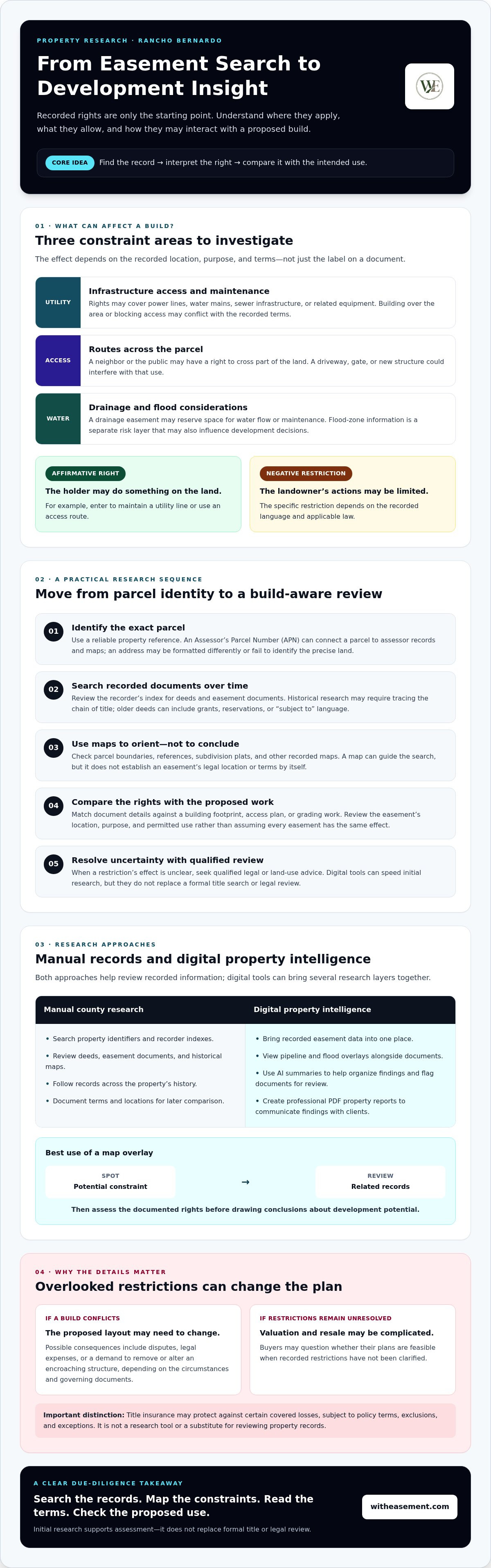
An easement gives someone a legal right to use part of another person’s land for a defined purpose. That right can affect where you place a building, how you access the site, and whether utility crews can reach infrastructure. A property easement search can help identify recorded rights to investigate. For a foundational overview, read what an easement is and how these rights differ from ownership.
Easements aren’t automatically deal-breakers. But an overlooked restriction can derail a proposed layout, prompt redesigns, or make a site less attractive to a buyer. Assess the document’s location, purpose, and terms against the intended development. Don’t assume every easement has the same effect.
Common Types of Encumbrances
Look for rights and restrictions that could overlap with planned construction or site work:
- Utility easements: May allow access to power lines, water mains, sewer infrastructure, or related equipment. Building over the area or blocking access may conflict with the recorded terms.
- Access easements: Can give a neighbor or the public a right to cross part of a parcel. A driveway, gate, or new structure could interfere with that use.
- Drainage and flood constraints: A drainage easement may reserve space for water flow or maintenance, affecting grading and site preparation. Flood-zone information is a separate layer of risk, but may also influence development decisions.
Read the Rights, Not Just the Label
An affirmative easement allows its holder to do something on the land, such as enter to maintain a utility line or use an access route. A negative easement restricts what the landowner can do. The exact rights depend on the recorded language and applicable law.
Recorded deeds, easement agreements, and maps can describe the affected area and permitted use. Compare those details with a proposed building footprint, access plan, or grading work. WithEasement tools can flag documents for review, but the recorded terms are essential to understanding the rights and restrictions.
The Cost of Ignoring Recorded Records
Building in conflict with an easement can lead to disputes, legal expenses, or a demand to remove or alter an encroaching structure, depending on the circumstances and governing documents. Unresolved restrictions can also complicate valuation and resale because buyers may question whether their plans are feasible.
Title insurance may provide protection for certain covered losses, subject to the policy’s terms, exclusions, and exceptions. It isn’t a research tool or a substitute for reviewing property records before making development decisions. Check the documents early, then seek qualified legal or land-use advice when a restriction’s effect is unclear.
The Traditional Process of a Property Easement Search
A thorough search starts with the property’s legal identity, then follows documents across time. A street address can help locate a parcel, but it may be formatted differently across systems or fail to identify the precise land being researched. An Assessor’s Parcel Number (APN) is a more consistent starting point for connecting a parcel to assessor records and maps. Search options vary, so check which identifiers the record system accepts.
Using the Assessor’s Parcel Number
Find the parcel’s APN through available assessor records or property documents, then use it to locate the parcel on official maps. An APN lookup guide can help you understand how to begin. Check the map’s boundaries and parcel references carefully: a map can orient your search, but it doesn’t establish the legal location or terms of an easement by itself.
For an overview of the underlying concept, Cornell Law School describes an easement as a legal right to use another person's land. That distinction matters during record research: documents may refer to the property benefiting from a right and the property subject to it, sometimes using terms such as “dominant” and “servient” tenement.
Follow the Recorder’s Index and Historical Maps
Once you have a reliable parcel reference, search the recorder’s index for relevant deeds and easement documents. A complete historical review may require tracing the chain of title, meaning the sequence of ownership and transfers. Older deeds can contain easement grants, reservations, or “subject to” language that doesn’t appear in a recent document. Subdivision plats and other recorded maps may also show dedications or rights affecting the parcel.
This takes patience. Names can vary between records, legal descriptions may be difficult to match, and each document may point to another record. Manual retrieval can involve navigating separate portals or visiting a government office. Search, copy, and processing fees vary, and turnaround times depend on the record custodian. Confirm current procedures and fees directly before planning around them.
Manual vs. Digital Record Retrieval
Manual research gives you access to source documents, but it can mean switching between indexes, maps, assessor records, and environmental data. HOA and flood information may sit in separate systems, making comparisons slower. Some relevant constraints may be visible on maps or arise from use without appearing as a recorded easement, so a recorder search alone may not reveal every concern.
Digital tools can organize recorded easement data alongside interactive pipeline and flood overlays, HOA information, and AI summaries. Use them to speed up initial review, then verify important findings against source documents. WithEasement’s property easement search tools can bring these research layers into one workflow. Digital results support due diligence, but don’t replace a formal title search or legal advice.
Manual County Research vs. Digital Property Intelligence Platforms
Manual research can mean moving between recorder indexes, parcel maps, flood resources, pipeline data, and HOA records. Each source adds context, but keeping everything aligned takes time and creates room for missed documents or mistaken connections. Digital property intelligence platforms bring relevant data into a more unified workflow, helping realtors review a property without starting each layer from scratch.
Speed matters, but speed alone isn’t due diligence. A digital result can help you spot a potential issue sooner; the recorded document still provides the terms you need to assess its effect. Use mapped results to guide document review, not replace it.
The Power of Integrated Map Overlays
An interactive map can make spatial relationships easier to see. Pipeline overlays may flag areas for closer investigation, while flood-zone layers can add context for site planning. HOA search data can also help identify an association whose governing documents may need review. These are distinct sources of information, so don’t assume that a map layer establishes an easement or fully defines its legal boundaries.
Interactive property maps can illustrate how multiple data layers are viewed together. For any mapped feature, compare its location with the parcel and confirm relevant rights or restrictions in the underlying records. Some development processes also refer to a recorded covenant of easement. Check the applicable documents and rules rather than assuming a map tells the full story.
Interpreting Complex Data with Technology
Recorded documents often use dense legal descriptions and specialized terms. AI-powered summaries can help surface key details, such as a stated purpose or access right, so you know which passages deserve a closer read. Use summaries to guide your review, then verify important interpretations against the source document. A summary is a starting point, not a legal opinion.
The practical shift is from scattered raw data to organized information. With easement details, HOA data, and flood and pipeline overlays gathered in one workflow, realtors can compare properties more consistently and prepare professional PDF reports for clients. A centralized view may also make multi-property reviews easier to track while reducing repetitive manual cross-referencing. It can’t guarantee that every relevant record or constraint is captured, so follow up on gaps and confirm findings with authoritative sources.
For a more organized first review, explore property intelligence tools that combine interactive maps, AI summaries, and report features.
Step-by-Step: How to Identify Easements and Land Use Constraints
Use a consistent review process to connect parcel records, mapped risks, and proposed plans. Digital tools can organize the first pass, while source documents and relevant authorities help confirm what each finding means.
- Start with the property identifier. Enter the address or APN into a property search platform. Check that the result matches the intended parcel before relying on its records or map layers.
- Review the interactive map. Look for pipeline and flood overlays, then compare their locations with the parcel boundaries and any proposed building area. A mapped feature is a prompt for further review, not a final determination of buildability or permit requirements.
- Read the recorded easement information. Open available documents and use AI summaries to help identify stated purposes, access rights, and restrictions. Confirm important details in the original document, especially its legal description and the land it affects.
- Check HOA and land-use context. Determine whether the parcel appears to fall within an HOA boundary, then obtain and review relevant governing documents. Separately check applicable land-use rules with the appropriate planning authority.
- Organize the findings. Create a property report that brings the reviewed records, map observations, and unresolved questions together for clients or other stakeholders.
Analyzing the Preliminary Title Report
Review Schedule B for listed exceptions, including recorded easements, rights-of-way, restrictions, and other matters affecting title. Note the document references and descriptions, then compare them with the parcel map and any proposed site plan. An exception may affect a specific strip of land or certain activities, so assess its actual wording rather than assuming every listed item blocks development.
Digital maps and summaries can help surface questions or show where an exception may relate to the parcel. They complement the title officer’s findings; they don’t replace the underlying report, source documents, or professional interpretation.
Evaluating Environmental and Infrastructure Risks
Check pipeline overlays for potential infrastructure conflicts, and review flood-zone information as a separate planning consideration. Neither layer alone confirms whether construction is allowed. Verify relevant findings with source data and the authorities responsible for applicable requirements. If HOA information appears, confirm the boundary and request governing documents before treating it as applicable.
A professional PDF property report can make these findings easier to share and revisit. Use WithEasement property search tools to review easement records, HOA data, and flood and pipeline overlays in one workflow.
Leveraging WithEasement for Professional Property Due Diligence
Property research gets easier to manage when key information is gathered in one workflow. WithEasement is a membership-based platform for realtors that supports searches for recorded easements and HOA data, alongside flood-zone information. Its interactive maps bring pipeline and flood overlays into view, helping you identify items that may need closer review without switching between as many separate sources.
AI-powered summaries can help translate dense recorded documents into clearer starting points. Use them to spot stated easement purposes, access rights, or restrictions that deserve attention. Then check the original document. A summary can make the research easier to navigate, but it doesn’t replace source records, legal advice, or a formal title search.
Tools for Realtor Due Diligence
Once you’ve reviewed the relevant records and map layers, a downloadable PDF property report can help present findings in a format that’s easier to share with clients. It can bring research into a professional deliverable and support clear conversations about what’s known, what may affect plans, and what still needs verification. That structure can build confidence without overstating what a map or summary proves.
A membership model gives real estate professionals access to the platform’s property research tools. The features include easement and HOA searches, interactive maps, AI summaries, and PDF reports. Check the membership details directly for current terms and included capabilities rather than assuming a particular search limit or reporting allowance.
From Records to Useful Insight
AI can make initial document review more approachable and direct attention to potentially relevant language. Keep the essential check in mind: verify any important summary against its source.
For agents, the benefit is a more organized path from scattered information to a client-ready view. Consolidating searches, map overlays, and summaries can reduce repetitive manual work, while a PDF report gives stakeholders a clear record of the findings. These tools support early due diligence; they don’t confirm that every constraint has been found or determine whether a specific project can proceed.
Make Your Next Property Review More Informed
A thorough easement review is about more than finding recorded documents. It means understanding how their terms may affect a proposed build, checking mapped pipeline and flood information, and confirming important findings against source records. Digital tools can help bring those details together, while AI summaries make dense documents easier to review and professional PDF reports help you share your findings with clients.
A Rancho Bernardo property easement search can be a more organized first step when you combine recorded easement research with map overlays and careful document review. Treat digital results as a starting point, and seek qualified advice when a restriction’s meaning or effect is unclear.
Start your property easement search with WithEasement to review available records and map layers, organize your findings, and prepare a clear report for your clients.
Frequently Asked Questions
How do I find a utility easement on my property online?
Start with the property’s address or assessor’s parcel number (APN) in a property search tool or the relevant records system. Check map layers for utility features, then locate and read any linked recorded easement documents. A pipeline or utility overlay can point you toward an area to investigate, but it doesn’t confirm the easement’s legal boundaries or terms. Verify important findings against source records.
What is the difference between a recorded and unrecorded easement?
A recorded easement is documented in public records, often through a deed, agreement, or map. An unrecorded easement may not appear in the recorder’s index, though a legal right could still be claimed or established under applicable law and circumstances. This means a document search may not reveal every possible property-use issue. If physical use, access, or a neighbor’s claim raises questions, seek qualified legal advice.
Can an easement be removed if it prevents property development?
Sometimes, but removal depends on the easement’s terms, the parties’ rights, and applicable law. The document may describe an end date or conditions for termination; in other cases, the holder’s agreement or a legal determination may be necessary. Don’t assume you can cancel or relocate an easement on your own. Have the recorded document reviewed by a qualified property attorney before changing plans or beginning construction.
How do I perform a property search by assessor parcel number?
Find the APN on a property tax bill, assessor record, or other official parcel document, then enter it into the relevant assessor or recorder search system. Confirm that the result matches the property and its parcel boundaries before reviewing records. Some property research platforms also support APN searches. Check their coverage and data sources first, since available records and search functions vary by jurisdiction.
Where can I find HOA information and governing documents for a parcel?
Begin by checking the property’s sale documents, seller disclosures, or available association information to identify a possible HOA. Contact the association or its management company to request governing documents, such as covenants, conditions, and restrictions, rules, and amendments. Recorded documents may also be searchable through the recorder. An HOA search tool can help identify relevant association information, but confirm boundaries and document details with authoritative sources.
What should I look for in a property data PDF report?
Check that the report identifies the correct parcel and clearly separates recorded documents from map overlays or other data layers. Review easement references, stated purposes, HOA information, and pipeline or flood indicators. Note the sources and any dates provided, then follow document references to verify key terms in the original records. Treat summaries and maps as research aids, not as a legal opinion or confirmation that a project is permitted.
How does a pipeline overlay affect my ability to build a pool or ADU?
A pipeline overlay flags a location for closer review, but it doesn’t by itself establish whether a pool or accessory dwelling unit (ADU) is allowed. Check the recorded easement or other relevant documents for access rights and restrictions, and ask the appropriate utility and permitting authorities about requirements for the proposed work. Compare those findings with site plans and parcel boundaries before deciding where to build.
Why is a digital property intelligence tool better than a county search?
A digital tool can make initial research more efficient by bringing selected records, parcel maps, HOA information, and risk overlays into one workflow. Some platforms also provide AI summaries and shareable PDF reports. It isn’t a complete substitute for public records: coverage may vary, and mapped data may not include every relevant document or right. Use digital results to guide your review, then verify important details with authoritative sources.


