

Your 10-digit Assessor Parcel Number used to be a digital key, but a 2024 policy shift means finding property data now feels like a step backward into the analog age. If you've tried to find easements by APN San Diego lately, you've likely hit a wall on the official County website. It's frustrating to waste hours navigating broken links or realizing that the public data you need is now buried behind a physical kiosk visit.
We understand that you need clear answers, not a research project. You want to know exactly where those utility lines or access rights sit without paying for irrelevant documents or squinting at blurry plat maps. This guide simplifies the process by showing you how to locate recorded easements and interpret complex data directly from your desk. You'll learn to transform a simple parcel number into a professional report, giving you the confidence that no hidden encumbrances will derail your build or sale. We'll walk through the exact steps to bridge the gap between raw public records and the actionable intelligence you need for your next project.
Key Takeaways
- Identify the 10-digit San Diego APN structure using tax bills or assessor maps to unlock precise property records.
- Follow a streamlined workflow to find easements by APN San Diego without the need for manual record office visits.
- Differentiate between common encumbrances like Public Utility Easements (PUE) and ingress/egress rights that affect land development.
- Expand your due diligence with critical overlays for flood zones and recorded HOA governing documents.
- Leverage AI-powered summaries to convert dense legal descriptions into professional, easy-to-read PDF reports for clients.
Understanding the Role of the APN in San Diego Land Records
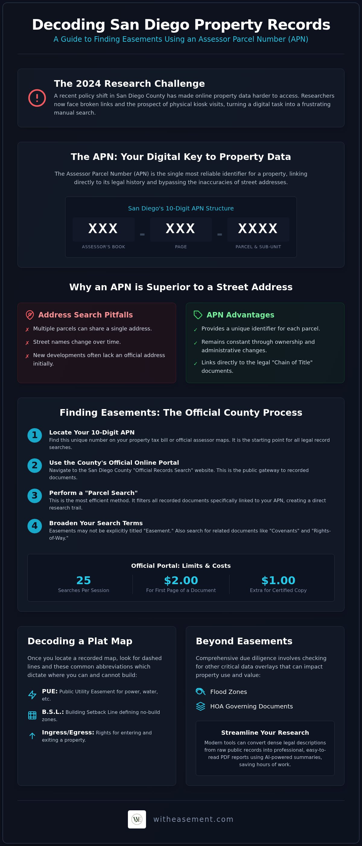
Start your research with the Assessor Parcel Number (APN). It's the digital DNA for every piece of land in San Diego County. While most people rely on street addresses, the APN is the only definitive way to track a property through history. San Diego uses a specific 10-digit format. The first three digits represent the Assessor's Book. The next three indicate the Page. The final four identify the specific Parcel and sub-unit. This hierarchical system lets the county map and tax millions of individual lots with surgical precision.
Use this identifier to find easements by APN San Diego databases. It provides a level of accuracy that a simple address search can't match. Easements are legal rights that allow others to use a portion of your land for a specific purpose. If you're wondering, What is an easement?, it's a non-possessory interest that stays attached to the land regardless of who owns it. Because these rights are tied to the physical boundaries of the parcel, the county indexes them directly against the APN in its legal archives.
Why Address Searches Often Fail in San Diego
Don't rely on a mailing address for serious property research. In many parts of San Diego, multiple parcels share a single address. You'll see this often with large rural estates or complex condo developments. Street names change over decades. New developments often don't get an official address from the post office until long after construction starts. APNs remain constant throughout these administrative shifts. If you're researching vacant land in East County or a newly subdivided lot, the APN is your only reliable starting point.
The Link Between APNs and Recorded Documents
Think of the San Diego property system as two connected databases. The Assessor’s office handles tax data and mapping. The Recorder’s office manages legal documents. When a utility company secures a right-of-way, they record an "Easement Deed" indexed by the parcel number. This creates a digital breadcrumb trail for your research. Using the APN lets you bypass tax noise and jump straight to the legal "Chain of Title." The Chain of Title is the complete chronological history of all official documents recorded against that specific San Diego parcel.
Step-by-Step: How to Find Easements by APN in San Diego
You have your 10-digit APN from your property tax bill. Now you need to translate that number into a list of legal encumbrances. Since December 9, 2024, the San Diego County official records website has restricted searches for the APN itself to protect owner privacy. However, if you already possess the parcel number, you can still find easements by APN San Diego through the County’s recorded document search. This method allows you to bypass the long lines at the County Administration Center and pull data from your home office.
Start by navigating to the official San Diego County records portal. Look for the "Official Records Search" section and select the option to search by parcel number. You aren't just looking for documents titled "Easement." Many restrictions are recorded as "Covenants" or "Rights-of-Way." Under California Government Code § 65871, an easement can be created by a recorded covenant between a property owner and the city or county. These documents are legally binding and "run with the land," meaning they stay attached to the APN even after the property sells. If the official portal feels clunky, you can generate a professional property report that organizes these findings automatically.
Using the County's Official Online Services
The County's official online interface offers two primary search paths: Grantor/Grantee or Parcel. For easement research, the Parcel search is your most efficient tool. It filters every recorded document specifically linked to your 10-digit identifier. Be aware that the county's online portal typically limits users to 25 searches per session. If you find a relevant document, you'll need to pay for a copy. Official copies cost $2.00 for the first page and $0.05 for each additional page. If you need a certified version for a building permit, expect an additional $1.00 certification fee per document.
Reading a San Diego County Plat Map
Once you locate a recorded map, look for dashed lines and abbreviations like "PUE" (Public Utility Easement) or "B.S.L." (Building Setback Line). These symbols dictate where you can and cannot build. Pay close attention to the "marginalia," which are the small notes in the map margins. These often reference older "Book and Page" numbers for deeds that contain the full legal description of the easement. For a more visual approach, cross-reference your findings with the County's geographic information system (GIS) data to see how these easements align with current topography and infrastructure.
Interpreting Your Findings: Common San Diego Easement Types
Once you successfully find easements by APN San Diego, the next step is decoding the legal language. These documents dictate how much of your property you actually control. In San Diego County, easements generally fall into four categories. Each carries different restrictions for homeowners, builders, and realtors. Understanding these distinctions prevents costly mistakes during the design or escrow phase.
- Public Utility Easements (PUE): These are the most frequent encumbrances. They grant gas, electric, and water companies the right to install and maintain infrastructure. You'll often find these along the front or rear property lines.
- Ingress/Egress Easements: These are vital for landlocked parcels in areas like Ramona or Fallbrook. They provide legal access for neighbors to cross your land to reach theirs.
- Sewer and Drainage Easements: These protect the flow of waste and storm water. You generally cannot place permanent structures, large trees, or heavy landscaping over these lines.
- Open Space or Conservation Easements: San Diego’s canyon-adjacent homes often feature these. They protect native habitats and coastal sage scrub. You own the dirt, but you can't clear the brush or build into the protected zone.
The Impact of Utility Overlays
Utility access is more than just a line on a map. In North County and East County, SDG&E holds extensive rights for high-voltage transmission lines. These easements often include strict "no-build" zones that extend far beyond the physical wires. Beyond simple utilities, you must check for hazardous infrastructure. High-pressure gas or fuel lines require specialized setbacks for safety. Before you break ground, consult San Diego pipeline overlay maps to ensure your project doesn't sit directly over a major transmission artery.
Red Flags in Easement Descriptions
Watch for specific phrasing that can devalue a property. A "Blanket Easement" is a major red flag. It doesn't define a specific path, meaning the holder could theoretically place infrastructure anywhere on the parcel. "Floating Easements" are similarly problematic; they allow the holder to relocate the easement as needed. If you see the term "exclusive use," it means the easement holder has rights that may completely bar you from using that portion of your land. When these terms appear, it's time to stop. Hire a licensed surveyor to stake the boundaries or a land use attorney to clarify your remaining rights. Don't guess when it comes to legal title.
Beyond Easements: Essential Property Data for San Diego Realtors
A clean title is only the first step in your due diligence. While you work to find easements by APN San Diego, you must also look for hidden financial and physical constraints. A property might have no access issues but could sit in a high-risk wildfire zone or carry a heavy Mello-Roos tax burden. These details are often buried in separate databases, but they're just as critical for a successful transaction or development project.
- Flood Zone Overlays: FEMA maps provide a federal baseline, but they're only half the story. San Diego’s unique canyon topography creates localized drainage risks that standard maps might miss. Always check municipal drainage overlays to see how water moves during heavy winter storms.
- HOA Information: Recorded CC&Rs dictate everything from paint colors to ADU potential. You need the specific management contacts to verify current dues and any pending special assessments.
- Assessed Values: Track the tax history to identify Mello-Roos assessments. These special taxes fund local infrastructure and can significantly increase a buyer’s monthly payment.
- Environmental Risks: San Diego’s "Very High Fire Hazard Severity Zones" trigger specific building codes and insurance requirements. Steep hillside restrictions also limit where you can safely place a foundation.
Navigating San Diego HOA Data
Tracking down homeowners association data is notoriously difficult in San Diego. Large master-planned communities are easy to spot, but smaller, self-managed associations often lack a digital footprint. You won't find their contact info on the tax bill. This search often requires digging through recorded "Management Certificates" in the county archives. To save time, use the HOA search by address feature to instantly pull association details and recorded governing documents.
Flood and Fire Risk Analysis
In 2026, wildfire safety is a top priority for San Diego homeowners. New "Zone Zero" defensible space requirements mean properties in high-risk areas must maintain a five-foot non-combustible zone around all structures. These regulations affect landscaping choices and construction costs. Flood risk is equally vital. Even if a property isn't in a 100-year flood plain, localized "nuisance flooding" can impact building permits and insurance premiums. Verify these environmental overlays before the 17-day contingency period ends to ensure your client isn't walking into a high-cost liability. Generate a professional PDF property report to see every hazard and restriction in one centralized view.
WithEasement: The Faster Way to Research San Diego Parcels
Stop jumping between fragmented county databases and outdated portals. WithEasement provides a centralized dashboard that brings every critical data point into a single, intuitive view. Use a 10-digit parcel number to find easements by APN San Diego alongside HOA details, flood risks, and pipeline overlays. It's a high-tech utility tool designed to eliminate the friction of property research. You get immediate insights without the need for specialized legal training or manual record office visits.
- AI Summaries: Our proprietary platform translates dense legal descriptions into plain English. You'll understand the exact scope of an encumbrance in seconds.
- PDF Property Reports: Generate professional, client-ready documents with one click. These reports bundle easements, environmental risks, and HOA data into a cohesive package.
- Interactive Map Overlays: Visualize hazardous infrastructure like high-pressure pipelines and see current assessed values across the county.
Why Professionals Choose WithEasement Over Government Sites
Government portals like ParcelQuest serve a purpose, but they come with significant barriers. The current 25-search limit on the ARCC portal often stalls research during busy listing periods. WithEasement offers a no-nonsense interface built for speed. You don't have to navigate multiple redirects or decipher archaic filing systems. A single WithEasement Membership grants you unlimited access to organized San Diego County data. It's about efficiency; you save hours of manual document review by letting our AI do the heavy lifting of organizing public records. You gain the power to find easements by APN San Diego without the administrative lag.
Generating a Professional Property Report
Trust is the most valuable currency in San Diego real estate. A WithEasement PDF report provides a transparent look at a property's history and potential liabilities. It includes confirmed easements, flood zone data, and HOA management contacts. Realtors use these reports to enhance listing presentations and provide buyers with comprehensive due diligence. This level of clarity reduces your professional liability by ensuring no hidden encumbrance goes unnoticed. It turns raw data into a competitive advantage for your business. Start your San Diego property easement search today with WithEasement.
Secure Your Property’s Future with Professional Intelligence
Property research in San Diego doesn't have to be a source of friction. You've seen how the 10-digit APN acts as the master key to unlocking a property’s legal history. By moving beyond simple address searches, you ensure that no hidden utility lines or access rights derail your development plans. Whether you're decoding a PUE or checking for wildfire overlays, having the right data at your fingertips is essential for any modern real estate professional.
You now have the exact steps to find easements by APN San Diego with precision and speed. Don't let manual search limits or complex legal jargon slow your progress. Use tech-forward tools to transform raw public records into professional PDF reports that build trust and reduce liability. You're now equipped to move forward with total confidence in your property data.
Access San Diego Easement Records and AI Summaries with WithEasement to leverage AI-powered summaries and reporting tools focused exclusively on San Diego County accuracy. Unlock the full potential of your parcel today.
Frequently Asked Questions
Can I find easements for free through the San Diego County Assessor?
You can view basic parcel maps through the Assessor’s portal, but official document copies aren't free. The San Diego Recorder charges $2.00 for the first page of a recorded document and $0.05 for each additional page. Since the 2024 policy shift, you must already have your APN to search online, as address-based lookups are restricted on the official county site.
What happens if an easement is not recorded on my APN?
Unrecorded easements are rare but can exist through prescriptive use or implied necessity. If a neighbor has openly used a path for years, they might claim a right even if it’s not in the county database. However, for a utility or access right to be legally enforceable against a new buyer, it generally must be recorded against the 10-digit parcel number.
How do I look up a San Diego APN if I only have the property address?
Check your most recent property tax bill or use a third-party data platform. Effective December 9, 2024, the San Diego County website discontinued online address-to-APN searches due to California Assembly Bill 1785. You can still perform these searches in person at county kiosks, but digital access now requires you to have the APN ready before you start your research.
What is the difference between a plat map and a recorded easement deed?
A plat map is a visual drawing that shows how land is divided and where general easements sit. A recorded easement deed is the actual legal contract. It contains the specific terms, maintenance responsibilities, and "metes and bounds" descriptions that a map might simplify. You need both to fully understand how an encumbrance affects your rights and property value.
Do San Diego easements expire or do they run with the land?
Most easements in San Diego "run with the land" and stay attached to the parcel indefinitely. They don't disappear when the property changes hands. An easement only expires if it has a specific sunset date in the original deed or if the holder signs a formal "Quitclaim Deed" to abandon their rights. Don't assume an old utility line is no longer active.
How do I find utility easements specifically for SDG&E or water lines?
Search for the "PUE" abbreviation on your parcel map to identify Public Utility Easements. To find easements by APN San Diego for specific providers, filter your search results for "Grant of Easement" or "Right of Way." These documents will list the utility company, such as SDG&E or a local water district, as the grantee. This identifies exactly where their infrastructure sits.
Can a WithEasement report replace a preliminary title report?
No, our report is a high-speed due diligence tool, not a title insurance product. It’s designed to help you identify red flags and analyze site constraints early in the process. While it provides the same data found in public records, lenders and escrow companies still require a formal preliminary title report to issue insurance and close a real estate transaction.
How accurate are the pipeline and flood overlays for San Diego County?
Our overlays utilize the latest municipal GIS data and FEMA flood maps for high accuracy. They reflect current hazard zones and infrastructure locations as of 2026. While these layers are excellent for initial site screening and risk assessment, you should always verify the exact location of underground lines with a physical survey before starting any excavation or foundation work on your lot.


