

What if you could bypass the hours spent digging through fragmented government portals and get a complete feasibility picture in seconds? You already know that missing a single pipeline overlay or misinterpreting a complex legal description can derail a project before it starts. The traditional process of land development research often feels like a race against shifting local regulations and buried public records. It's frustrating to waste time on multiple websites only to find data that's difficult to visualize or present to a client.
This guide helps you master the complexities of modern property due diligence by using a streamlined approach to zoning, easements, and environmental data. You'll gain the ability to secure instant access to critical property overlays and generate professional reports that provide total confidence in land use feasibility. We'll explore the latest 2026 fee structures, along with updated inclusionary housing requirements and the digital tools that turn hours of manual searching into immediate, actionable insights. By the end of this guide, you'll have a clear path to faster, more reliable property intelligence.
Key Takeaways
- Learn a systematic 5-step workflow to verify property rights and map legal boundaries using precise APN matching.
- Identify hidden public utility, private access, and sewer easements that can significantly impact your project's footprint.
- Streamline your land development research San Diego by moving beyond manual government site navigation to automated property intelligence.
- Interpret complex CC&Rs and legal descriptions instantly using AI-powered summaries and interactive map overlays.
- Generate professional PDF property reports that provide clear, authoritative insights for clients and stakeholders.
The Fundamentals of Land Development Research in San Diego
Land development research is the systematic verification of every right, restriction, and requirement attached to a specific parcel. It's the process of unearthing the legal, environmental, and regulatory DNA of a property before capital is committed. The Fundamentals of Land Development involve transforming the natural landscape into a built environment; a process that requires absolute certainty. Without a rigorous deep dive, developers are essentially gambling on the feasibility of their projects.
Due diligence serves as the foundation for any successful real estate investment. It identifies what's possible versus what's prohibited. Modern land development research San Diego rests on three primary pillars. First, legal encumbrances, which include easements, liens, and CC&Rs. Second, environmental risks, such as flood zones or underground pipelines. Third, zoning regulations that dictate density, height, and setbacks. The industry has moved away from time-consuming courthouse visits. Today, professional research utilizes digital property intelligence to provide a high-resolution view of feasibility in seconds.
Why Preliminary Research Prevents Project Failure
Skipping the initial deep dive often leads to crippling hidden costs. An overlooked utility easement might require a complete redesign of a foundation or an expensive utility relocation. Zoning also plays a critical role in your "highest and best use" calculations. If you miscalculate the allowable density or fail to account for the $737 General Plan Maintenance Fee, your ROI projections will be wrong. Recorded easements are equally influential. They frequently dictate building footprints by establishing "no-build" zones. These restrictions limit exactly where structures can sit on the land, regardless of the total lot size.
The 2026 Landscape of Land Records
The era of physical plat maps and dusty files is over. In 2026, the landscape of land records is defined by digital GIS overlays and instant data transparency. This shift from physical to digital has changed how professionals operate. Centralized data platforms reduce the risk of missing recorded documents that might be buried in disparate government databases. Digital transparency ensures that high-level data is now within reach for everyone, not just those with specialized training. By visualizing records in a single interface, you can spot conflicts immediately. This modern approach to land development research San Diego ensures that every decision is backed by the most current property data available.
Essential Data Points for San Diego Property Analysis
Effective land development research San Diego begins with a single identifier: the Assessor Parcel Number (APN). This universal key unlocks the entire history of a property. It allows you to cross-reference data with the San Diego Development Services Department to find active permits, historical violations, and specific building codes. Without the correct APN, you risk pulling data for the wrong lot or missing critical updates in the city’s records. It's the bridge between a physical address and the legal reality of the land.
Easements and Encumbrances
Understanding the specific nature of a restriction is just as important as knowing it exists. You must distinguish between easements in gross and easements appurtenant. An easement in gross typically benefits a specific entity, like a utility company, and doesn't transfer with the land. Conversely, an easement appurtenant stays with the property and benefits the owner of an adjacent parcel. Identifying public utility, private access, and sewer easements is vital for site planning. These determine where you can dig, build, or pave. You can identify these recorded documents by address or APN to see exactly where these rights-of-way sit. For a deeper look at the process, check out this guide on San Diego property easement search.
Environmental and Infrastructure Overlays
Flood risk and pipeline proximity are deal-breakers if ignored during the planning phase. Use the latest 2026 flood zone maps to determine if a project requires specialized insurance or elevated construction. High-risk zones can significantly increase your build costs or even prohibit certain types of residential development. Similarly, identifying pipeline overlays ensures safe excavation and prevents catastrophic utility strikes. These overlays provide a visual boundary that protects your investment and the community.
HOA status is another critical data point often overlooked by novice developers. CC&Rs (Covenants, Conditions, and Restrictions) can impose much stricter height limits, material requirements, or design standards than the city’s base zoning. These private rules can add months to your development timeline if you have to seek variances from an HOA board. Accessing centralized property intelligence ensures you don't miss these hidden layers during early-stage due diligence. By visualizing all these data points in one place, you turn a complex search into a streamlined verification process.
Public Records vs. Property Intelligence Platforms
Traditional land development research San Diego often feels like an obstacle course of disconnected government portals. While official county and city websites provide the raw data, they rarely offer the synthesis needed for rapid decision-making. You might find a permit on one site, a tax record on another, and a flood map on a third. This manual approach is slow. It forces you to act as a data aggregator rather than a professional analyst. Property intelligence platforms act as the bridge, pulling these disparate threads into a single, actionable view.
Accuracy is paramount in this industry. Official records are the source of truth, but their refresh rates and user interfaces vary wildly. Navigating a 1990s-style government database to find a specific easement is a poor use of a professional's time. Modern platforms solve this by indexing these official records and presenting them through a high-performance interface. This ensures you’re looking at the most current data without the friction of traditional search methods. Stop hunting for data and start interpreting it.
The Silo Problem in Government Databases
San Diego's data landscape is notoriously fragmented. City and county records require entirely separate search processes. A property might have a city-level permit issue, but the easement that restricts your building footprint is recorded at the county level. Overlaying environmental risks, such as pipeline proximity or flood zones, adds a third layer of complexity. Searching these silos individually is redundant and increases the risk of human error. Centralized platforms eliminate these steps. They allow you to view legal parcel maps and environmental overlays simultaneously. This holistic view is essential for identifying conflicts before they become expensive problems.
The Efficiency Dividend for Professionals
For realtors and developers, speed is a competitive advantage. Quantifying the hours saved per transaction reveals a significant "efficiency dividend." Instead of losing half a day to manual cross-referencing, property intelligence tools deliver results in minutes. This allows you to provide instant value to clients during a walkthrough or initial consultation. The professional presentation of these findings also matters. A high-quality PDF report builds trust faster than a collection of scattered screenshots from government websites. To see how technology is reshaping this process, explore our AI for real estate due diligence San Diego guide. Leveraging these tools transforms you from a data hunter into a high-value facilitator.
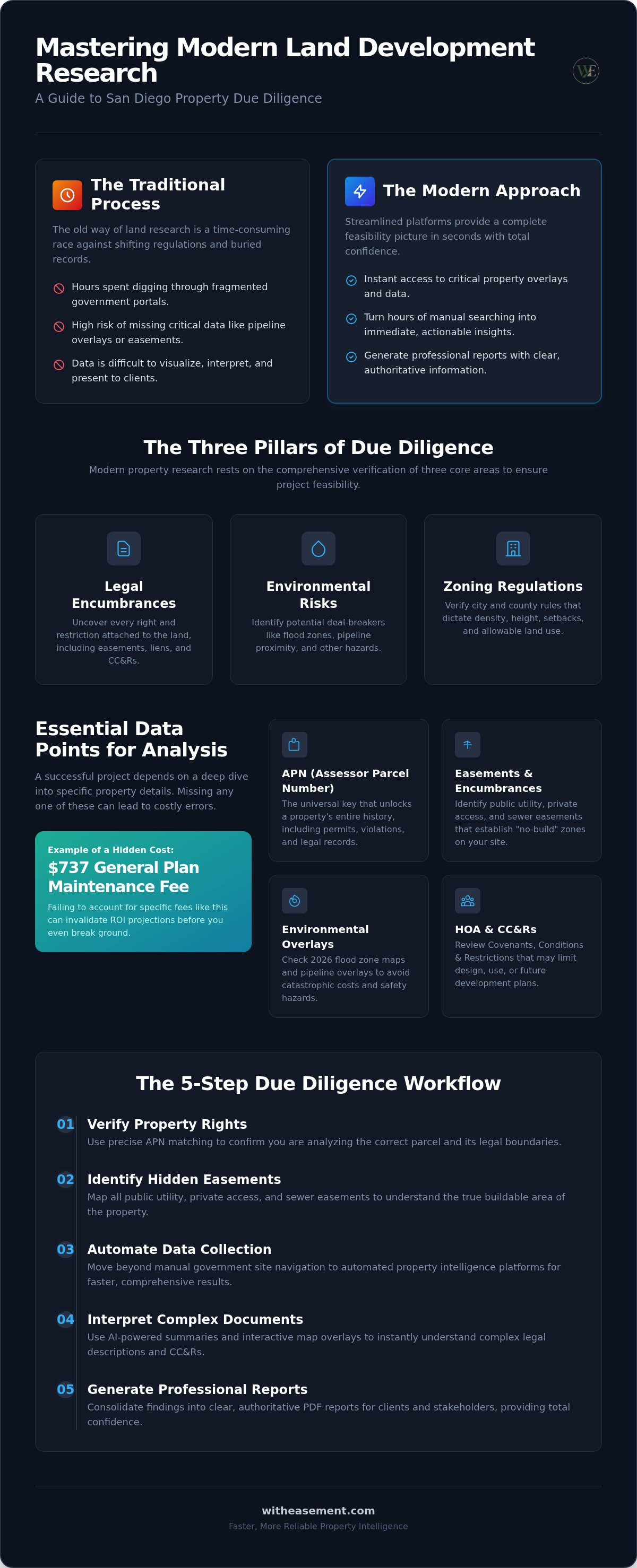
5-Step Due Diligence Workflow for Developers
Mastering land development research San Diego requires a repeatable process that eliminates guesswork. Efficiency isn't just about finding data; it’s about following a sequence that reveals project killers early. This 5-step workflow ensures you cover every critical angle from parcel identification to final reporting.
- Step 1: Identify the Parcel. Use the Assessor Parcel Number (APN) for precise record matching. Relying on street addresses alone leads to errors in multi-lot developments.
- Step 2: Map Legal Boundaries. Visualize recorded easements and setbacks. Knowing where a sewer line or private access road sits dictates your buildable footprint.
- Step 3: Assess Risk Overlays. Check current 2026 flood zone maps and utility pipeline proximity. These environmental factors determine insurance costs and safety requirements.
- Step 4: Verify Governance. Review zoning restrictions and HOA involvement. Factor in 2026 costs like the $737 General Plan Maintenance Fee and the $12.16 Mapping Fee to keep your budget accurate.
- Step 5: Generate Findings. Synthesize all data points into a professional report. This final document serves as the foundation for your investment decision.
Step-by-Step Parcel Verification
Accuracy begins at the source. Before diving into complex analysis, you must ensure you are researching the correct legal lot. Cross-reference address data with official assessor records to confirm boundaries and ownership. This initial screening is your best opportunity to spot red flags. If the APN reveals an irregular lot shape or a history of permit denials, you can adjust your strategy before spending more time on the project. High-volume professionals use this step to filter out non-viable properties in minutes.
Synthesizing Data for Stakeholders
Raw data is rarely enough for lenders, partners, or non-professional buyers. You need to translate technical land use data into a clear "Property Intelligence" packet. This packet should highlight the feasibility of the project while documenting all known restrictions. Maintaining a digital audit trail of your research is vital for long-term project management. It protects you against future disputes and provides clarity during the permitting process. Access these tools through a WithEasement Membership to automate your entire workflow and generate professional PDF reports instantly. By presenting a cohesive narrative, you build trust and accelerate the approval cycle for your development projects.
Streamlining Research with WithEasement Technology
Modern land development research San Diego requires more than just access to data. It requires a tool that synthesizes information instantly. The WithEasement interactive map provides real-time visualization of property constraints. You can toggle pipeline and flood zone overlays to see exactly how they intersect with a specific parcel. This visual approach replaces the need to cross-reference multiple static maps from various government departments. It turns a fragmented search into a cohesive discovery process. You see the whole picture on one screen.
Our platform acts as a high-tech utility for real estate professionals. It bridges the gap between dense public records and actionable insights. By centralizing HOA data, easements, and environmental risks, we remove the friction typically associated with due diligence. This efficiency allows you to move from initial curiosity to deep insight without leaving the interface. You save time, reduce stress, and build a more reliable foundation for your projects.
AI-Powered Property Summaries
Reading through a 20-page legal description of an easement is a slow process that invites human error. Our AI-powered summaries act as a translator for these complex documents. The technology scans recorded records to extract key dates, involved parties, and specific land use restrictions instantly. It highlights the most critical "project killers" so you don't have to hunt for them. This automation ensures that you never misinterpret a complex legal clause or miss a hidden restriction. You get professional-level clarity without the need for specialized legal training. It's about getting the right answers fast.
Professional Reporting for Realtors
Your research is only as valuable as your ability to communicate it. Customizing PDF reports allows you to showcase your expertise to clients and stakeholders. These reports consolidate flood data, pipeline proximity, and HOA status into a single, authoritative document. Instead of sending a collection of scattered screenshots, you deliver a professional property intelligence packet. This level of detail builds immediate trust and helps move transactions forward. It provides a clear audit trail for lenders and partners, ensuring everyone is on the same page. Start your research with a WithEasement membership today to unlock these professional reporting tools and streamline your entire workflow.
The membership model is designed for high-volume professionals who need consistent property intelligence. It provides a scalable solution for teams that handle multiple transactions across San Diego County. By removing the barriers to high-level data, we empower you to act with total confidence. You gain a competitive advantage by being the fastest, most informed person in the room. Professional land research isn't just about finding data anymore; it’s about the speed of interpreting it.
Secure Your Project’s Future with Precision Data
Mastering land development research San Diego is no longer about how much data you can find; it’s about how quickly you can interpret it. You've seen how a structured 5-step workflow and modern digital tools transform hours of manual searching into minutes of insight. Identifying easements, zoning restrictions, and environmental overlays early protects your investment from costly surprises and project delays. It turns a fragmented process into a clear path forward.
Efficiency defines success in the 2026 real estate market. You can now access interactive San Diego map overlays and AI-powered property summaries to simplify even the most complex legal descriptions. Instead of digging through fragmented government portals, use a professional PDF report generator to present findings to your clients with total confidence. Unlock professional property intelligence with WithEasement and take control of your due diligence today. You have the tools to turn complex property data into your greatest competitive advantage.
Frequently Asked Questions
How do I find land development records for a specific San Diego property?
You can access these records through official development portals or a centralized property intelligence platform. Start by identifying the property's APN to ensure you're viewing the correct legal lot. This unique number allows you to track permit history, recorded easements, and active zoning cases across different databases. Using a professional platform streamlines this process by pulling data from multiple government silos into a single interactive map for faster, more reliable verification.
What is the difference between a property easement and a zoning restriction?
An easement is a specific legal right for another entity to use a portion of your land, such as a utility company's access to a sewer line. A zoning restriction is a government-mandated rule that dictates how the entire property can be used, including density or height limits. Both are vital components of land development research San Diego. One defines private access rights while the other establishes the broad regulatory framework for your project.
Can I search for San Diego property easements by APN online?
Yes, you can search for recorded easements by using the Assessor Parcel Number on specialized property intelligence platforms. This method is often more accurate than searching by street address because APNs link directly to the legal parcel map. This digital approach allows you to visualize exactly where a utility or private access easement sits on the property. It eliminates the need for physical courthouse visits or time-consuming manual document requests.
How do I check if a property is in a flood zone in San Diego County?
Check the current 2026 flood zone maps provided by FEMA or use an interactive property intelligence map with environmental overlays. These digital tools allow you to toggle flood risk layers directly over a specific parcel to see potential buildability issues. Identifying these zones early is essential for determining insurance requirements and specialized construction codes. It ensures your development plan accounts for environmental risks before you commit capital to a new project.
What information is included in a professional property intelligence report?
A professional report synthesizes technical data into an actionable summary for stakeholders and clients. It typically includes recorded easements, HOA status, flood zone risk, and pipeline proximity overlays. These reports also feature AI-powered summaries of complex legal descriptions and current assessed values. Generating a PDF report provides a clear audit trail for lenders and partners. It transforms raw data into a professional presentation that builds trust and accelerates the project approval cycle.
Why is HOA information critical for land development research?
Homeowners Association rules often impose much stricter limitations than standard municipal zoning codes. These private CC&Rs can restrict building materials, landscaping choices, or even the addition of accessory dwelling units. Identifying HOA involvement early prevents unexpected delays in your development timeline. It allows you to factor in board approval processes and specialized design guidelines during the initial feasibility phase. This data is a cornerstone of thorough land development research San Diego.
How does AI help in summarizing property easements and land use records?
AI technology acts as a digital translator for dense, technical legal documents and property records. It scans recorded easement records to instantly extract key dates, involved parties, and specific land use restrictions. This process reduces human error and saves hours of manual reading. By providing a clear summary of complex clauses, AI empowers you to interpret property rights without specialized legal training. It turns intimidating public records into straightforward, actionable insights.
Is a property intelligence platform better than searching county records manually?
A property intelligence platform is significantly more efficient because it eliminates the "silo" problem of manual searching. Instead of visiting multiple government websites for zoning, environmental, and legal data, you access everything in one centralized dashboard. These platforms offer interactive overlays and automated reporting tools that raw databases lack. This streamlined approach saves hours of administrative work and provides a more cohesive, visual view of property feasibility for real estate professionals.


