

A standard utility map can locate a buried transmission line, but it won't show the enforceable land rights that halt your construction plans. When searching for a pipeline easement map, you are rarely just looking for underground infrastructure; you need to know whether you can safely build a pool, patio, or home addition without encroaching on a utility corridor.
Piecing together fragmented public portals and dense deed language is exhausting, especially when municipal datasets obscure the exact boundaries of a right-of-way. You shouldn't have to decipher complex legal filings just to protect your investment. In this guide, offered by WithEasement, you will discover how to access pipeline easement maps, identify underground rights-of-way, and evaluate property restrictions before closing a deal. We'll examine where public GIS tools fall short, unpack critical clearance rules, and walk through how to verify parcel encumbrances with total confidence.
Key Takeaways
- Consulting an Oceanside pipeline easement map helps you distinguish between physical pipe centerlines and enforceable right-of-way boundaries before making an offer.
- Public municipal and national pipeline viewers often leave out private transmission corridors or lack parcel-level precision.
- Proactive easement due diligence confirms mandatory clearance buffers, protecting you from buying land that prohibits pools, decks, or additions.
- Modern property intelligence tools combine parcel lines, pipeline overlays, and plain-English summaries to replace slow manual archive searches.
What an Oceanside Pipeline Easement Map Reveals About Property Rights
Public utility maps often mark where pipes run underground, but they rarely reveal how those pipes govern surface land use. An Oceanside pipeline easement map does far more than plot utility infrastructure; it details legal property boundaries where operators possess binding rights across a parcel. Consulting these records confirms dedicated rights-of-way that restrict what you can construct, plant, or alter on a property.
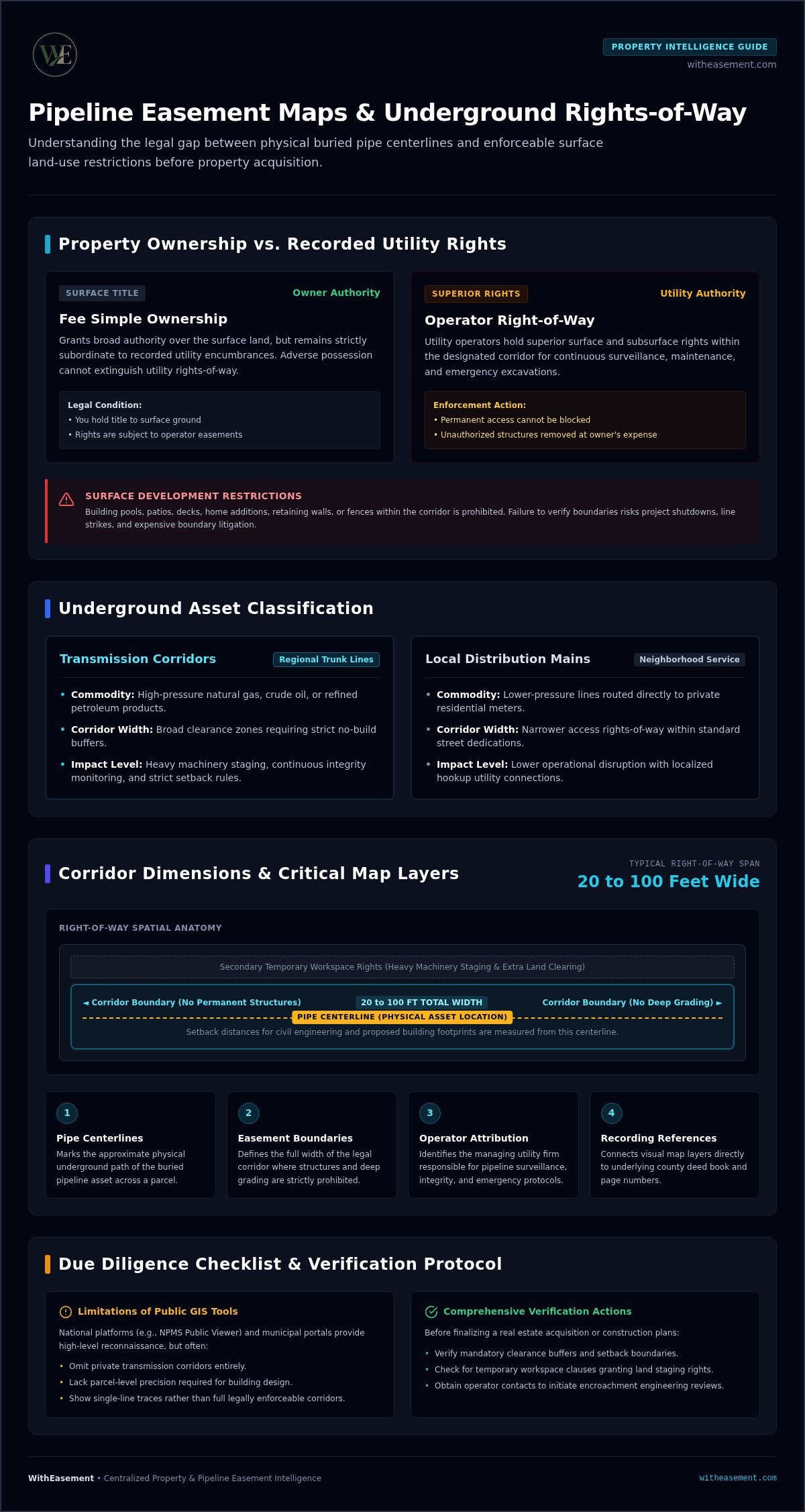
A common misconception is that an easement only covers the physical pipe. In practice, the recorded right-of-way extends outward from the pipe centerline into a wide, protected corridor. Within this designated zone, utility operators retain permanent access for heavy equipment, inspections, maintenance, and emergency excavations. You hold title to the surface land, but you surrender the freedom to build permanent structures over that ground. Analyzing corridor maps early prevents catastrophic line strikes, project shutdowns, and expensive boundary litigation.
Utility Rights-of-Way vs. Fee Simple Ownership
Purchasing real estate grants fee simple ownership, giving you broad authority over the land. However, this title remains subject to recorded encumbrances. Under the established legal principles of property easements, utility operators hold superior surface and subsurface rights within the easement boundaries. You cannot use adverse possession to extinguish a utility right-of-way, nor can you block operator entry. Fences, retaining walls, and accessory structures built within these strips remain vulnerable to removal at the owner's expense whenever repairs arise.
Transmission Corridors vs. Local Utility Distribution Lines
Understanding the utility asset type clarifies the practical constraints on a parcel. Properties face two main underground classifications:
- Transmission corridors: High-pressure trunk lines that transport volatile liquids or natural gas across regional networks. These lines require broad clearance widths, strict no-build zones, and extensive continuous inspection buffers.
- Local distribution mains: Neighborhood service lines running within standard street dedications to deliver utility connections directly to private meters. These carry lower pressure and feature narrower access corridors.
Reviewing an Oceanside pipeline easement map helps you immediately distinguish between low-impact service hookups and heavy transmission corridors before finalizing a real estate acquisition.
Key Data Layers to Examine on an Interactive Pipeline Easement Map
Reading a digital property overlay requires looking past a simple single-line trace. An effective Oceanside pipeline easement map integrates multiple spatial layers, stacking cadastral parcel boundaries, infrastructure centerlines, and corridor buffer zones into a single view. Evaluating these distinct elements together tells you where the metal sits underground and shows the full legal footprint impacting surface rights.
Every comprehensive map layer provides vital context for due diligence:
- Pipe centerlines: Mark the approximate physical path of the buried pipeline across a parcel.
- Total easement boundaries: Define the full width of the right-of-way corridor where structures and deep grading are prohibited.
- Operator attribution: Identifies the managing utility firm responsible for pipeline integrity, surveillance, and emergency protocols.
- Document recording references: Connects visual map lines directly to underlying county deed book and page numbers.
Corridor Dimensions, Centerlines, and Setback Boundaries
Utility corridors vary widely, often ranging from 20 to 100 feet in total width. Centerline coordinates help civil engineers calculate exact setback distances to proposed building footprints. When assessing a parcel, check whether the easement includes secondary temporary workspace rights. These auxiliary clauses give operators legal authorization to stage heavy machinery and temporarily clear land beyond the primary corridor boundary during scheduled repairs.
Commodity Specifications and Operator Oversight Information
Not all pipelines present identical risks or regulatory obligations. High-level reconnaissance tools, like the federal National Pipeline Mapping System Public Map Viewer, distinguish whether a transmission asset transports high-pressure natural gas, crude oil, or refined petroleum products. These datasets provide operator contact points so you can initiate mandatory engineering encroachment reviews prior to design finalization.
Sifting through multiple government portals to stitch these data points together slows down critical transactions. To quickly inspect boundary setbacks alongside utility corridors, modern teams rely on platforms like WithEasement property easement search to streamline site due diligence in seconds.
Where to Access Pipeline Maps: Municipal GIS vs. National Platforms
Pinpointing an underground utility corridor requires knowing where public records end and private operational data begins. If you search for an Oceanside pipeline easement map across disparate public portals, you quickly run into inconsistent data standards. Public records vary dramatically in resolution, update frequency, and accessibility, leaving substantial blind spots for prospective buyers and developers.
Municipal GIS viewers excel at showing tax parcel boundaries, zoning classifications, and city-managed storm drains. However, they routinely omit privately operated interstate transmission lines. Dialing 811 dispatches a field locator to mark active pipes before someone digs, but paint on grass provides zero documentation regarding recorded title rights or long-term structural restrictions. To evaluate risk before closing, you must review permanent property instruments.
Limitations of the National Pipeline Mapping System
Federal mapping platforms offer valuable macro-level overviews but fall short during parcel-level due diligence. Regulations cap the public viewer resolution at a 1:24,000 scale, with a geospatial tolerance margin of roughly 500 feet. At that distance, line features disappear before you can zoom into a residential lot. The public viewer also excludes gathering systems and municipal distribution mains. When assessing land rights, consulting official FERC landowner easement guidance underscores why broad national maps cannot replace parcel-specific easement verification.
Municipal GIS Portals vs. Centralized Intelligence Platforms
Relying solely on local government archives introduces administrative friction. Municipal departments typically silo their records:
- Local public works databases: Track municipal water and sewer connections while excluding private energy transmission corridors.
- County recorder portals: Host scanned legal deeds, grants, and easement text, but lack interactive spatial mapping to visualize physical boundaries.
- Integrated intelligence tools: Combine parcel geometries, flood hazard overlays, and verified pipeline corridors into an instant, interactive workspace.
Navigating fragmented databases creates unnecessary risk during short escrow windows. Utilizing an interactive Oceanside pipeline easement map on a unified spatial platform bridges the gap between raw legal text and real-world property boundaries.
How to Verify Pipeline Easements During Property Due Diligence
Proactive easement verification protects buyers from unexpected building restrictions and severe financial liabilities. Discovering an active high-pressure line across your backyard after closing can derail plans for a swimming pool or detached guest house. Executing a structured due diligence workflow ensures no subsurface encumbrances slip through uninspected.
Begin by securing the parcel Assessor Parcel Number (APN) to confirm official lot dimensions and identify historical deeds. Pair those records with an on-site physical inspection. Look for telltale surface indicators such as bright yellow or orange pipeline marker posts, cathodic protection test boxes, and cleared vegetation paths. When physical markers or title exceptions appear, cross-reference them against an Oceanside pipeline easement map to measure their exact spatial relationship to planned home improvements.
Cross-Referencing APN Data with Preliminary Title Commitments
Never rely solely on standard policy summaries. Turn directly to Schedule B of the preliminary title commitment, where title companies list specific exceptions to coverage:
- Identify recorded right-of-way grants: Search for language referencing pipeline utility grants, dedicated transit corridors, or private transmission agreements.
- Track underlying document numbers: Note the specific book and page references, then pull the source instruments to verify rights-of-way width.
- Confirm temporal alignment: Match recording dates against historical property subdivision phases to identify whether older lines retain active maintenance covenants.
Evaluating Prohibited Structures: Pools, Patios, and Outbuildings
Easement documents outline what you can and cannot build within corridor boundaries. Permanent concrete foundations, inground pools, and habitable additions are universally forbidden. These structures block immediate emergency excavation and risk puncturing utility infrastructure. While fences, driveways, and light landscaping might seem harmless, they generally demand written encroachment agreements from the operating utility. If you build without authorization, operators possess legal authority to tear down conflicting structures at your personal expense.
Avoid expensive closing mistakes and eliminate guesswork. Use WithEasement property easement search to examine interactive parcel overlays, review underlying covenants, and verify utility corridors before your inspection contingencies expire.
Modernizing Property Research with Centralized Easement Intelligence
Hunting through multiple public archives eats up valuable transaction hours during active escrow. Traditional research means requesting land documents from physical branches, deciphering antiquated plat drawings, and cross-checking parcel numbers across disconnected portals. Sifting through disparate systems introduces unnecessary delays and leaves room for costly oversights. A modern property intelligence platform eliminates this friction by unifying parcel boundaries, pipeline overlays, and hazard datasets inside a single, intuitive interface.
Instead of manually toggling between municipal GIS layers and recorded county instruments, centralized spatial tools align property records into a unified workspace. Reviewing an Oceanside pipeline easement map alongside active parcel data allows agents, developers, and investors to spot subsurface conflicts immediately, speeding up due diligence workflows from days to seconds.
Deciphering Complex Legal Covenants with Automated Document Summaries
Historical easement deeds often contain dense legal jargon that obscures practical land-use limitations. Decades-old agreements frequently bury critical covenants under pages of technical legalese, making it hard to find essential restrictions. Automated AI document interpretation extracts these vital details instantly, converting dense text into actionable takeaways:
- Corridor maintenance parameters: Clarifies exact vehicle clearance requirements and designated points of ingress or egress.
- Future installation rights: Flags secondary clauses that permit operators to lay additional pipelines within an existing corridor.
- Surface restoration liabilities: Confirms whether operators must repair disturbed grounds or replace hardscaping following pipeline repairs.
Generating Client-Ready Due Diligence Reports
Delivering clear, professional documentation builds client trust and protects transactions. Rather than sending clients raw, low-resolution screen captures from municipal viewers, professionals can generate downloadable PDF property reports. These dossiers compile verified parcel boundaries, flood zones, and transmission pipeline overlays into an easy-to-read format. Providing concrete spatial proof helps buyers make confident purchase decisions before removing formal contingencies. Sign up for a WithEasement Membership to access comprehensive property data and streamline your land research today.
Take Control of Your Property Due Diligence
Uncovering underground utility rights shouldn't stall your real estate deals. Knowing whether a parcel intersects an active right-of-way gives you the power to negotiate effectively, plan future development, and avoid prohibited construction. Consulting an accurate Oceanside pipeline easement map ensures you aren't guessing about corridor setbacks, building limitations, or utility access rights when evaluating a parcel.
Instead of wrestling with fragmented municipal archives or low-resolution public viewers, streamline your due diligence workflow with modern property intelligence. Centralize interactive parcel boundaries, flood zones, and transmission corridors into a single, intuitive view. Pair automated deed summaries with downloadable PDF property reports to confirm encumbrances and protect your transactions in minutes. Search property pipeline overlays and recorded easements today to turn complex utility records into decisive, confident property investments.
Frequently Asked Questions
Can you build a fence across an active pipeline easement?
Yes, but you usually need written authorization from the pipeline operator through a formal encroachment agreement. Operators often permit fences crossing perpendicular to a pipe if you install unlocked gates for emergency vehicle access. Installing post holes directly over the line or running fences lengthwise down the corridor is strictly prohibited. Operators can remove unapproved fences at your expense.
How do I verify if a pipeline easement crosses a specific parcel?
You can verify a crossing by checking your parcel identifier against a modern spatial property platform and reviewing recorded land records. Search Schedule B of your preliminary title commitment for utility right-of-way exceptions. Cross-referencing those recorded documents with an interactive Oceanside pipeline easement map confirms the precise corridor dimensions and shows where restrictions fall relative to your property lines.
What happens if a property owner damages an underground pipeline?
Damaging a transmission line triggers immediate financial liability, safety penalties, and mandatory repair fees. Striking a line without calling 811 beforehand carries civil fines reaching up to $50,000 under state excavation regulations. Property owners are held responsible for repair expenses, environmental remediation, and lost commodities, along with potential criminal penalties if catastrophic damage or personal injury occurs.
Are pipeline easements permanent, or do they expire over time?
Most utility rights-of-way run with the land in perpetuity and do not expire. Pipeline grants are recorded as easements in gross, binding all future property owners indefinitely. The easement remains fully enforceable even if the pipe sits dormant, unless the operating company officially executes and records a formal abandonment instrument in public deed records to extinguish its legal rights.
Can pipeline operators access residential private property without advance notice?
Yes, pipeline operators hold legal access rights to enter the corridor immediately during emergency inspections or active leaks. While utility crews typically provide courtesy notices before conducting standard maintenance, recorded easement terms grant immediate entry whenever public safety requires it. Property owners cannot lock gates, build blockades, or hinder authorized utility personnel from reaching the designated right-of-way.
How does the presence of a pipeline easement impact property market value?
Impact on market value depends on the corridor width, parcel size, and surface restrictions. Easements that consume prime yard space or forbid swimming pools, decks, and outbuildings can reduce buyer demand and lower appraised value. Checking an Oceanside pipeline easement map early helps you evaluate whether the right-of-way runs along an outer boundary or cuts directly through prime buildable areas.
What is the difference between an 811 utility locate and an easement map?
An 811 locate marks active buried pipes on the ground, while an easement map outlines enforceable legal property boundaries. Field technicians spray temporary surface paint to guide safe excavation for immediate projects. An easement map displays recorded property rights, legal corridor widths, and permanent building setbacks that govern land ownership long after surface paint marks have washed away.


