

What if pinpointing every recorded restriction on a parcel took sixty seconds instead of three days lost in government archives? Conducting an Encinitas property easement search has traditionally meant wrestling with fragmented public databases, decoding dense legal descriptions, and dealing with California AB 1785 online parcel search restrictions. It is slow, tedious, and prone to costly oversights.
You already know the frustration of chasing down missing utility lines, drainage covenants, or coastal bluff setbacks. When an overlooked easement surfaces halfway through escrow or during architectural review, projects stall and client trust evaporates immediately.
This guide shows you how to master locating and interpreting recorded easements and zoning codes in Encinitas using modern digital tools and public records. We will cover how to verify property boundaries, interpret municipal overlay zones, and turn raw land records into visual maps and clear PDF reports you can deliver directly to clients.
Key Takeaways
- Master the difference between parcel addresses and APNs to quickly pull accurate San Diego County land records.
- Accelerate your Encinitas property easement search to identify utility corridors, access rights, and municipal zoning restrictions before escrow issues arise.
- Save valuable research time by comparing the cost and turnaround of manual recorder visits against instant digital platforms.
- Spot hidden hazards beneath the surface by pairing interactive pipeline and flood zone overlays with automated AI summaries.
- Deliver comprehensive PDF property reports combining recorded easements, HOA details, and risk data directly to your clients.
Starting Your Encinitas Property Easement Search: Address vs. APN
Every successful property investigation begins with precise identification. When you start an Encinitas property easement search, using a standard postal address feels natural, but it often leads directly to dead ends in county systems. San Diego County administrative databases organize, index, and protect recorded documents using the Assessor Parcel Number (APN). Understanding how this identifier functions makes the difference between locating an active right-of-way in seconds and missing critical encumbrances entirely.
Before pulling recorded documents, always verify the boundary lines on an official assessor plat map. Plat maps provide the exact dimensional footprint of the parcel, displaying lot lines, recorded subdivision names, and original dedication notes. Confirming these lot configurations ensures you are researching the actual dirt your client intends to buy or build on, especially when dealing with complex legal definitions of easements that bind specific portions of servient tenements.
The Role of the Assessor Parcel Number (APN)
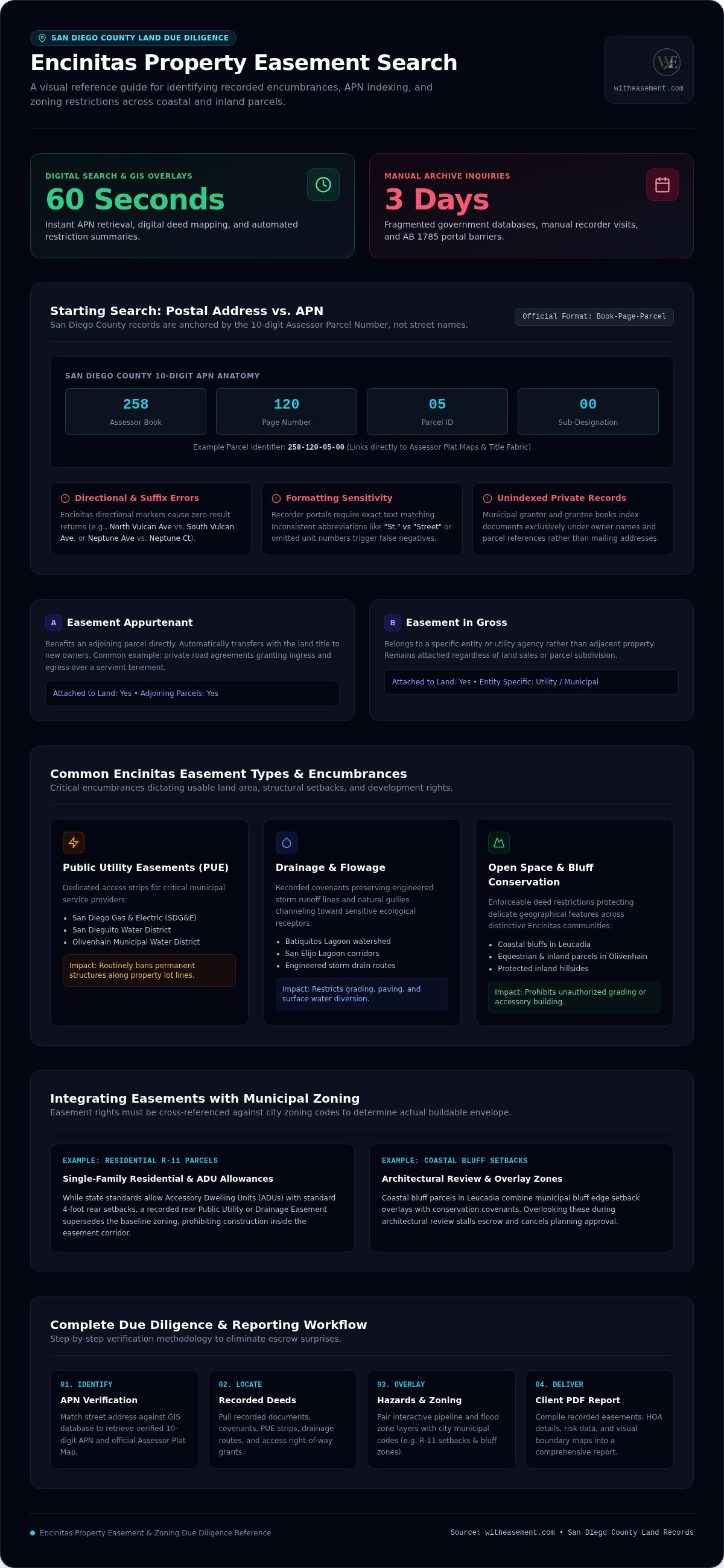
In San Diego County, the APN is a 10-digit numeric sequence typically formatted as Book-Page-Parcel (for example, 258-120-05-00). This sequence functions as the legal bridge connecting physical land to historical deeds, covenants, and municipal records. While postal addresses change over time, the parcel number anchors title records directly to the San Diego County land fabric. You can skip the tedious step of manually parsing assessor indexes to find your number. Simply search your street address or parcel on WithEasement to retrieve the verified APN and immediately open recorded property details.
Address-Based Searching Pitfalls
Relying solely on street addresses inside traditional government portals introduces significant error risks:
- Directional and street suffix errors: Encinitas contains numerous directional markers and similar names, such as North Vulcan Avenue versus South Vulcan Avenue, or Neptune Avenue versus Neptune Court. A missing letter triggers immediate zero-result errors.
- Government formatting quirks: Official county recorder systems require exact text matching. Inconsistent abbreviations like "St." instead of "Street" or omitted unit numbers frequently cause portals to return false negatives.
- Unindexed private records: Municipal grantor and grantee books index documents under owner names and parcel references rather than mailing addresses.
Modern platforms eliminate this friction by automatically normalizing raw address inputs. They match your target property against official GIS databases, confirm the boundaries, and prepare your Encinitas property easement search for complete, error-free document retrieval.
Identifying Key Easement Types and Encinitas Zoning Codes
An Encinitas property easement search reveals far more than boundary stakes. It uncovers what an owner can legally construct, pave, or expand. In Encinitas, recorded easements directly dictate usable land area. Whether dealing with a coastal bluff parcel in Leucadia or an equestrian parcel in Olivenhain, locating recorded rights-of-way and municipal development standards at the same time prevents costly architectural blind spots.
Common Encinitas Easements
Recorded agreements in Encinitas generally fall into two primary categories: appurtenant and in gross. An easement appurtenant benefits an adjoining parcel, such as a private road agreement granting ingress and egress. An easement in gross belongs to a specific entity rather than adjoining land, remaining attached regardless of property sales. Common encumbrances include:
- Public Utility Easements (PUE): Dedicated strips granting San Diego Gas & Electric (SDG&E), San Dieguito Water District, or Olivenhain Municipal Water District access. These routinely ban permanent structures along property boundaries.
- Drainage and Flowage Easements: Recorded covenants preserving natural gullies and engineered storm drains running toward Batiquitos or San Elijo Lagoons.
- Open Space and Bluff Conservation Easements: Enforceable deed restrictions protecting sensitive coastal bluffs and inland hillsides from unauthorized grading or accessory construction.
Integrating Zoning Code Lookups
A recorded easement is only half the development puzzle. You must evaluate it alongside municipal zoning regulations. For example, a parcel zoned Single-Family Residential (such as R-11) might permit an Accessory Dwelling Unit (ADU) with four-foot rear setbacks under California housing laws. However, if a 10-foot recorded utility easement runs along that same rear property line, the easement always takes precedence. The utility company can require the removal of any structure within their right-of-way, completely overriding standard setback allowances.
Avoid researching these factors in isolation. While the official City of Encinitas E-Zoning tool provides standard municipal codes and base setback tables, it doesn't display your private recorded deed instruments. You can streamline this due diligence by using WithEasement property search tools to evaluate recorded encumbrances alongside critical parcel layers, giving you a complete development picture before submitting building plans.
Manual vs. Digital Search: Navigating San Diego County Records
Executing an Encinitas property easement search generally forces you to pick between two paths. You can spend hours navigating county record systems, or you can use modern property intelligence platforms that aggregate everything instantly. Understanding the friction built into official municipal archives highlights why modern digital tools are transforming real estate due diligence.
When you examine nonpossessory rights, grants, and abandonment clauses outlined in the Legal Information Institute's easement overview, the legal scope is clear. Locating those physical instruments inside government repositories, however, remains remarkably difficult.
The Traditional Government Portal Route
Conducting your search through the San Diego County Assessor/Recorder/County Clerk (ARCC) website requires several manual steps:
- No online APN search: Under California AB 1785, you cannot search recorded documents online by APN. You must look up the current owner name or document number first. APN-indexed recorded searches are restricted to in-person kiosks at ARCC offices like San Marcos.
- Grantor/Grantee indexing: You must trace historical property owners backward through title transfers to find original easement grants.
- Statutory document fees: The ARCC charges $2.00 for the first page and $0.05 for each additional page of standard documents, plus $1.00 for certifications and a $2.50 card fee. Map copies exceeding 11" x 17" cost $13.00 for the first page. These piecemeal costs add up quickly when pulling multiple historic deeds.
The WithEasement Digital Advantage
Digging through siloed county sites often results in missed encumbrances. A WithEasement Membership bypasses these administrative bottlenecks entirely. Instead of toggling between assessor files, recorder indexes, and municipal zoning maps, you get a single pane of glass for your property research.
The platform consolidates your Encinitas property easement search with interactive layers, instant HOA data, and flood risk boundaries. Visual overlays replace the guesswork of interpreting hand-drawn plat maps from the 1960s. For a broader perspective on handling properties across the entire region, explore our guide to the San Diego property easement search.
Leveraging AI and Map Overlays for Complex Interpretation
Modern due diligence requires more than simply retrieving an old document from an archive. The real challenge lies in interpreting how historical grants interact with subterranean infrastructure and environmental hazards. Combining advanced machine-learning tools with dynamic GIS layers allows you to complete an Encinitas property easement search while discovering critical property risks that standard title reviews regularly overlook.
Visualizing Hidden Risks
Overlay analysis is the layering of multiple geographic datasets on a single map to evaluate spatial relationships across parcel boundaries. In coastal and bluff-adjacent zones like Encinitas, this capability protects developers and buyers from severe physical constraints:
- High-pressure transmission lines: Underground natural gas and fuel pipelines frequently traverse private parcels under blanket utility easements. Standard title reports list the recorded instrument number, but they rarely pinpoint the exact subterranean run across a backyard. Digital pipeline overlays reveal these lines instantly.
- Special flood hazard boundaries: Encinitas contains complex coastal drainage corridors discharging toward local lagoons. Flood zone overlays identify base flood elevations, revealing mandatory insurance obligations and municipal building restrictions under municipal floodplain overlay zones.
- Assessed values and transfer history: Visualizing historical tax assessments alongside boundary maps provides complete transactional context, highlighting previous lot splits and dedication events.
AI-Powered Document Summarization
Deciphering century-old metes-and-bounds deed language consumes valuable hours. AI summaries bridge this operational gap by scanning recorded instruments, identifying servient versus dominant tenements, and extracting core operational restrictions instantly. Instead of parsing pages of dense legal phrasing, real estate professionals get a clear, bulleted breakdown of access terms, maintenance costs, and building limitations in plain English.
This automated approach transforms routine due diligence into a competitive advantage. To discover how modern firms apply machine intelligence to streamline property workflows, read our guide on AI for real estate due diligence San Diego.
Stop wasting billable hours manually deciphering complex deed covenants. Explore witheasement.com to unlock instant AI summaries and interactive pipeline overlays for your target properties today.
Generating Professional Due Diligence Reports for Encinitas Real Estate
Transforming complex public records into actionable buyer clarity represents the ultimate goal of property research. While raw data protects against unexpected surprises, how you present that information shapes transaction momentum. Compiling zoning overlays, recorded covenants, and subsurface infrastructure into a unified presentation elevates your due diligence, establishing immediate credibility with clients during critical disclosure timelines.
A structured Encinitas property easement search serves both sides of a deal. Buyers gain certainty regarding future pool installations, second-story additions, or perimeter fences. Sellers eliminate the liability of unrecorded surprises surfacing during escrow inspections. Anchoring your presentation in verified San Diego County recorded records guarantees the accuracy required for high-stakes coastal investments.
The Anatomy of a Property Report
An effective due diligence summary packages multiple municipal datasets into a clean, client-ready layout:
- APN and boundary identification: Verified 10-digit assessor parcel numbers paired with parcel maps and legal descriptions.
- Recorded easement schedule: Specific lists of public utility easements, ingress and egress rights, and open space deeds with clear plain-language descriptions.
- HOA and development constraints: Verified association jurisdictional status, common area covenants, and architectural review requirements.
- Environmental and utility mapping: Visual GIS overlays showing flood hazard zones and high-pressure transmission corridors across lot lines.
Featuring these insights during listing presentations sets an exceptional professional standard. Using a WithEasement Membership, real estate professionals instantly package these critical datasets into clean, branded PDF property reports that simplify complex property disclosures.
Next Steps for Real Estate Professionals
Navigating municipal planning departments and county archives shouldn't drain your weekly schedule. Eliminating manual portal hopping frees you to focus on closing escrows and advising clients. Centralized platforms deliver direct access to recorded San Diego County encumbrances, environmental hazard zones, and HOA verification in minutes.
Start your professional property search with WithEasement today to access automated AI summaries, dynamic overlays, and instant due diligence reports across Encinitas.
Take Control of Your Next Encinitas Land Review
Accurate land intelligence no longer requires days of sorting through county archives or guessing at obscure deed restrictions. Anchoring your property evaluation in verified parcel data, checking municipal zoning setbacks, and exposing subsurface utility corridors protects your transactions from costly delays. Modern digital platforms have transformed the traditional Encinitas property easement search from a frustrating administrative roadblock into an immediate competitive advantage.
Visual clarity and speed are now within your reach. Explore interactive San Diego County maps with pipeline and flood overlays, generate instant AI-powered summaries of complex recorded deeds, and export downloadable professional PDF property reports for your buyers and sellers. Access Encinitas Easement Records & Map Overlays with WithEasement to make your next real estate transaction seamless, transparent, and completely protected.
Frequently Asked Questions
How do I find a utility easement on my property in Encinitas?
Review the recorded subdivision plat map and original grant deed for your parcel. You can run an Encinitas property easement search on WithEasement using your address or APN to view digital pipeline overlays and recorded utility access corridors instantly. Alternatively, check historical recorded instruments through county recorder kiosks or submit a records request directly to the local water district or SDG&E.
Where can I look up the Encinitas zoning code for a specific address?
Look up local zoning designations using the City of Encinitas online E-Zoning tool or the municipal GIS Data Hub. Entering your street address displays your zoning classification, such as R-11 single-family residential or commercial. This lookup identifies standard building setbacks, maximum lot coverage ratios, and height limits established under Title 30 of the Encinitas Municipal Code.
Is a property easement search free in San Diego County?
Viewing parcel lines on basic public GIS maps is free, but pulling official recorded easement instruments costs money. The San Diego County Assessor/Recorder/County Clerk charges statutory fees starting at $2.00 for the first document page and $13.00 for large map sheets. Using a dedicated platform like WithEasement consolidates these records with interactive overlays, saving you the expense and delay of buying individual deed files.
What is the difference between a recorded easement and a zoning setback?
A recorded easement is a private property right granting an outside party legal access to a specific portion of your land, while a zoning setback is a municipal law establishing how far buildings must sit from property boundaries. Easements run with the land title and override standard setbacks. If city zoning permits a four-foot setback but a ten-foot utility easement exists, the easement controls the space.
How can I find out if a property is in an HOA in Encinitas?
Check the preliminary title report or perform an HOA search on WithEasement to verify association oversight immediately. You can also inspect the property's recorded covenants, conditions, and restrictions (CC&Rs) filed with the county recorder. Older developments in Olivenhain or Cardiff may belong to voluntary road maintenance groups rather than formal HOAs, making recorded document verification essential before closing escrow.
Can I build a fence over a public utility easement in Encinitas?
Usually you can install removable fencing across a public utility easement, but you do so at your own risk. Utility operators retain the legal right to remove, damage, or demolish any obstruction within their right-of-way during emergency repairs without reimbursing the homeowner. Always check the recorded easement grant language and verify local city building clearance rules before digging post holes.
How do I find my Assessor Parcel Number (APN) online?
Enter your street address into WithEasement to pull your verified 10-digit Assessor Parcel Number instantly. You can also locate the number on your annual San Diego County property tax bill or via the SanGIS interactive parcel lookup tool. Having your APN handy is essential because county systems organize and index land records, deeds, and official plats strictly by parcel number.
What information is included in a WithEasement property report?
A WithEasement property report delivers a comprehensive due diligence summary in a single downloadable PDF. Each report includes your APN data, recorded easement schedules, HOA details, and high-resolution parcel boundaries. You also get clear GIS map visuals displaying interactive flood zone boundaries and high-pressure pipeline overlays, backed by AI summaries that translate complex deed restrictions into straightforward, actionable insights for clients.


