

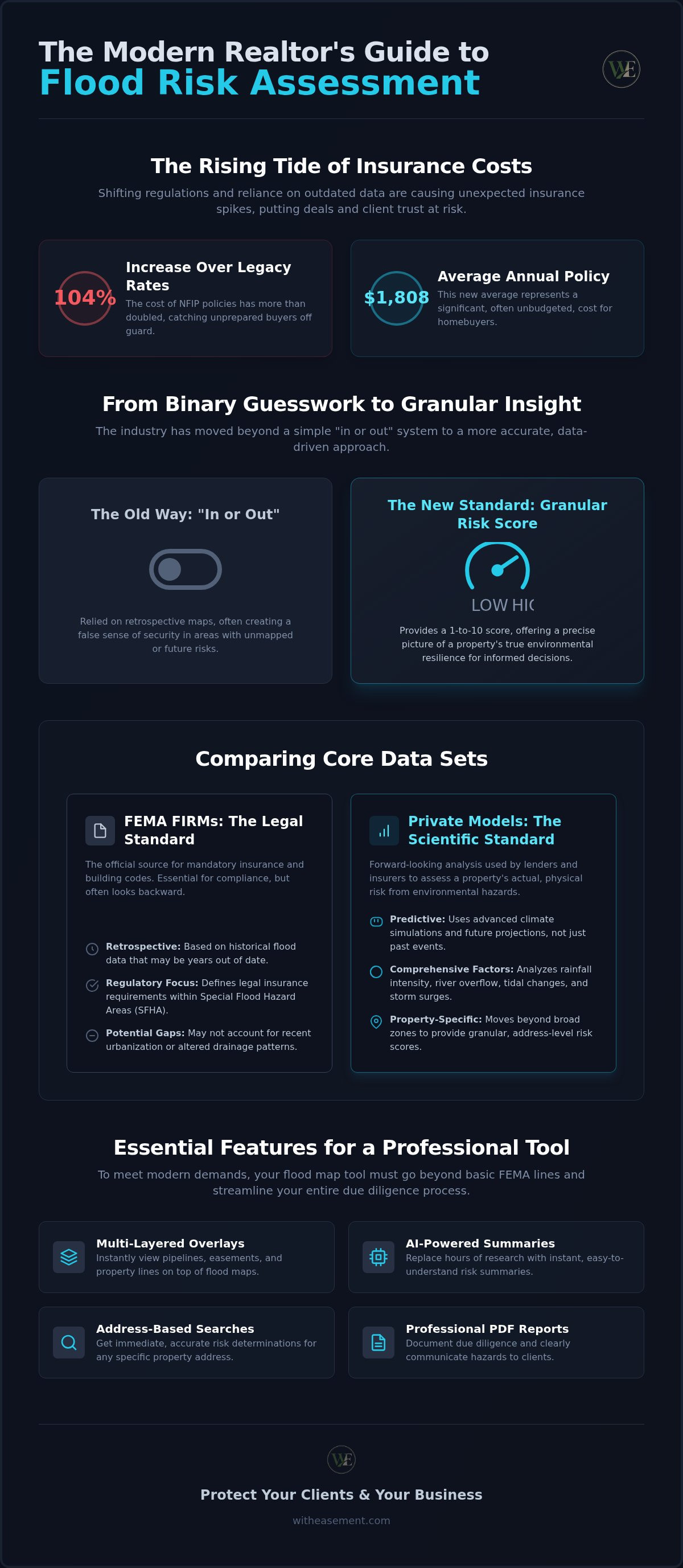
Did you know the average NFIP policy now costs $1,808 annually? That is a 103.6% increase over legacy rates, and it's catching unprepared buyers off guard. You likely feel the pressure of keeping deals on track while managing fragmented data and shifting regulations. Finding a reliable realtor flood zone map tool is no longer just a convenience; it's a necessity for avoiding non-disclosure liability and unexpected insurance spikes. It's exhausting to cross-reference multiple sites just to give your client a straight answer about property risk.
This guide helps you reclaim your time and authority. You'll learn to master the tools and data sets needed to provide accurate flood risk determinations that protect your clients from environmental hazards. We will explore how to integrate FEMA standards with private-sector projections to build professional-grade summaries. By the end of this article, you'll be able to document your due diligence clearly, communicate insurance requirements effectively, and speed up the offer process with confidence.
Key Takeaways
- Understand why FEMA maps are only the starting point in 2026 and how to bridge the gap with scientific climate data.
- Identify the essential features of a professional realtor flood zone map tool, including multi-layered overlays for pipelines and easements.
- Implement a "Source of Information" disclosure strategy to shield yourself from liability while providing accurate environmental risk summaries.
- Streamline your due diligence with address-based searches and AI-powered summaries that replace hours of manual research.
- Produce professional PDF reports to help clients visualize insurance requirements and potential hazards before they sign an offer.
The Evolution of Flood Zone Determination for Real Estate Agents
Flood Zone Determination is the formal process of identifying a property’s risk level within the National Flood Insurance Program (NFIP) framework. It serves as the primary gauge for insurance requirements and building regulations. In the past, this was a simple administrative step. In 2026, it has evolved into a complex risk assessment that defines property value and buyer confidence. The industry has moved away from a binary "In or Out" system. We now use granular risk scoring, often on a scale of 1 to 10, to provide a more accurate picture of environmental resilience. Modern buyers expect this level of detail before they commit to a mortgage.
Why Traditional Mapping is Falling Behind
Standard Flood Insurance Rate Maps (FIRMs) remain the legal standard for insurance mandates. However, they are often retrospective. They rely on historical data that fails to keep pace with rapid urbanization and shifting weather patterns. This creates "unmapped" risks in areas previously considered safe. There is often a significant gap between legal insurance requirements and the actual physical risk to a structure. Using a basic realtor flood zone map tool that only shows FEMA lines can lead to a false sense of security for your clients. You need to look at future projections, not just historical averages.
The Realtor’s Duty of Disclosure in 2026
The legal landscape for real estate professionals has shifted significantly. Recent precedents confirm that sophisticated environmental data is now considered a material fact. Because this information is accessible to the public, agents face increased liability for failing to disclose discoverable hazards. You don't have to be a technical surveyor to protect your business. You do need to act as a facilitator of high-level data. By using a professional realtor flood zone map tool, you can document your due diligence and provide the transparency that modern buyers expect. Effective disclosure is no longer just about avoiding lawsuits; it's about building trust in a market that prioritizes long-term resilience.
Market trends in 2026 show that environmental resilience is a core component of property valuation. Homes with documented low risk or mitigation features are commanding higher prices. As an agent, your ability to interpret these data sets quickly is a competitive advantage. It allows you to guide your clients toward safer investments while reducing the friction of the offer process.
FEMA FIRMs vs. Private Risk Models: Comparing Core Data Sets
FEMA's Flood Insurance Rate Maps (FIRMs) are the legal backbone of the real estate industry. They dictate mandatory insurance requirements and local building codes. However, they aren't the only data points you need to consider. Private climate models offer a "Scientific Standard" that often differs from FEMA's "Legal Standard." While FEMA focuses on regulatory compliance, private models analyze physical risk using advanced simulations. Lenders and insurance companies often use these sophisticated data sets to price premiums or assess loan risks. In the 2026 regulatory environment, understanding Special Flood Hazard Areas (SFHA) is critical for meeting realtor disclosure obligations and protecting your clients from uninsurable properties or unexpected costs.
Understanding FEMA FIRMettes and NFHL Viewers
Extracting a FIRMette is an essential step for any professional property file. This full-scale section of a FEMA map serves as your documented proof of due diligence. You can access these through the National Flood Hazard Layer (NFHL) viewer. Always check the "Effective Date" on the map legend. In rapidly developing areas, a map from several years ago may not account for new infrastructure or altered drainage patterns. If the date is old, the legal boundary might not match the current physical reality. You can find these data points faster using a dedicated realtor flood zone map tool that overlays these maps with current property lines and pipeline data.
The Rise of Property-Specific Risk Scores
Private models calculate risk using a broader range of factors than traditional mapping. They evaluate rainfall intensity, river overflow, tidal changes, and storm surges. This data is vital for buyers considering a 30-year mortgage commitment. A property might sit in "Zone X," which suggests a low legal risk, yet carry a high private risk score due to local drainage issues or future sea-level projections. Providing this granular data helps your clients understand the long-term cost of ownership. It moves the conversation from simple compliance to real-world protection. Use these scores to identify properties that might face rising insurance premiums under Risk Rating 2.0, even if they aren't currently in a high-risk zone.
By comparing these two data sets, you provide a more complete picture of a property's health. You help your clients see beyond the legal minimums. This level of insight builds professional authority and ensures your buyers aren't surprised by environmental hazards after the closing date.
Key Features to Look for in a Realtor-Focused Flood Mapping Tool
A professional realtor flood zone map tool must do more than display blue lines on a map. In a 2026 market where speed is everything, you need a centralized platform that synthesizes multiple data sets instantly. Address-based searches are the gold standard for efficiency. They allow you to bypass the friction of looking up Assessors Parcel Numbers (APNs) during a busy walkthrough. You need property intelligence that is mobile-responsive and ready for on-site decision-making.
Interactive Map Overlays and Data Synthesis
Effective risk assessment requires seeing the big picture. While the FEMA Flood Map Service Center provides raw regulatory data, a professional tool layers this information with pipeline and easement data. This synthesis helps you identify localized water flow issues or potential building restrictions that a standard flood map might miss. Parcel boundary overlays are equally vital. They allow you to confirm exactly where a flood zone line bisects a structure. This is a critical detail for determining insurance mandates and long-term property value.
Professional Reporting and Export Capabilities
You need a digital paper trail for every transaction. Look for tools that generate client-ready PDF property reports. These summaries should be easy to read for non-technical buyers and comprehensive enough to include flood, pipeline, and easement details. Generating these reports in seconds saves you hours compared to manual FEMA searches. It also provides a documented record of your due diligence. This shields your business from future liability claims while providing your clients with the transparency they expect.
AI-Powered Interpretation Tools
Dense recorded documents often hide flood-related encumbrances. AI-powered property summaries can scan these records and highlight key risks in plain English. This technology reduces the time you spend hunting through public records. Instead of interpreting complex legal jargon, you get a clear overview of the property's environmental health. This allows you to explain risk to your clients with confidence and clarity. It turns a technical hurdle into a professional advantage.
Speed is the most important feature in a competitive market. Your mapping tool should provide "instant" results that allow you to move from curiosity to deep insight without delay. Being able to visualize risk on-site during a property tour gives you an immediate advantage. It ensures your clients make fast, informed decisions based on the most accurate data available in 2026.
Best Practices for Disclosing Flood Risk and Managing Liability
Managing liability in 2026 requires a consistent Standard Operating Procedure (SOP). You should check the flood status of every property before the listing agreement is even signed. Use a professional realtor flood zone map tool to generate a risk summary for your internal file. This proactive step ensures you aren't blindsided by a map update or a high-risk score during the inspection period. When you share this data, use a "Source of Information" disclosure strategy. Always state that the information comes from third-party experts. This clarifies your role as a facilitator of data rather than a technical surveyor.
Data also helps you set realistic expectations for insurance premiums. With the average NFIP policy now costing $1,808 annually, buyers need to know the financial impact of a property's location early. FEMA’s Risk Rating 2.0 methodology means that even properties outside high-risk zones can face significant costs based on specific variables. Providing this context prevents sticker shock and keeps the deal moving. Always recommend that your clients consult with a specialized flood insurance agent to get a precise quote before removing contingencies.
Integrating Flood Checks into the Listing Presentation
Proactively addressing flood zones is the best way to avoid "deal-killers." If a property is in a high-risk area, disclose it immediately. Use the data to highlight any mitigation features or high-resilience ratings that justify the listing price. Standardizing the delivery of flood reports to all prospective buyers creates a transparent environment. It shows you've done the heavy lifting and value the buyer's time. You can generate professional property reports in seconds to include in your digital disclosure package.
Buyer Side Due Diligence: Beyond the Basics
Help your buyers understand the critical difference between "required" and "recommended" insurance. A lender might not mandate a policy for a Zone X property, but a high private risk score suggests it's still a wise investment. Identifying properties with historical claims is also vital. These claims can impact future insurability and premium costs significantly. If a property sits directly on a zone border, encourage your buyer to perform an independent survey. This level of due diligence reduces the risk of a post-closing surprise and reinforces your position as a knowledgeable specialist. It turns a potential liability into an opportunity to demonstrate your professional value.
WithEasement: Streamlining Professional Risk Assessment and Reporting
WithEasement serves as the ultimate realtor flood zone map tool for professionals who value their time and accuracy. It acts as a centralized command center for property intelligence, eliminating the need to juggle multiple government portals and fragmented data sites. By integrating high-level data into a single, intuitive interface, it provides the effortless efficiency required in 2026. This platform combines official FEMA data with pipeline overlays and easement searches. You get a complete risk profile in seconds simply by searching an address.
A WithEasement membership replaces a dozen disconnected tools with one high-tech utility. It bridges the gap between raw public records and professional insight. You no longer have to explain why a map looks outdated or why a drainage issue was missed. You simply provide the data and let the platform do the heavy lifting. This is how modern agents manage environmental risk and close deals with confidence.
Instant Insights with AI Summaries
Manual research is a relic of the past. Our platform utilizes AI-powered summaries to interpret dense recorded documents instantly. It distills complex flood risk, HOA regulations, and easement data into a single, readable summary. This automation saves hours of manual labor per transaction. It also identifies "hidden" risks that a standard map check might miss, such as specific building restrictions or historical drainage encumbrances. You get the clarity of an expert analysis without the specialized training or the wait. Use these insights to guide your clients through the complexities of modern property ownership with ease.
Generate Professional Reports in Seconds
Transparency builds trust. WithEasement allows you to generate professional PDF property reports designed for immediate client sharing. These reports present technical data in a clean, authoritative format that buyers can actually understand. Providing a comprehensive report demonstrates your commitment to due diligence. It positions you as a tech-forward specialist who proactively protects their clients' interests. While you can explore specific features in our San Diego Interactive Property Map: The 2026 Guide to Real Estate Intelligence, the underlying technology works across the nation to simplify your professional workflow. Every report serves as a documented digital paper trail of the information provided during the transaction, shielding your business from future liability while providing buyers with the data-backed advice they deserve.
Take Command of Property Risk Assessment
The real estate landscape in 2026 demands a higher standard of due diligence. Legacy data isn't enough to protect your reputation. You've seen how the gap between official FEMA maps and actual physical risk leads to professional liability. By integrating private models and interactive overlays, you provide the transparency that modern buyers expect. A professional realtor flood zone map tool is the key to managing these environmental complexities with speed and precision.
You now have the strategy to automate your research and standardize your disclosures. It's time for a single, high-tech utility that works as fast as you do. Access National Property Intelligence with a WithEasement Membership to unlock AI-powered property summaries and professional PDF reports instantly. Centralized flood and pipeline overlays help you visualize risks on-site. Empower your practice with the tools built for the future of property intelligence. You're ready to lead with absolute confidence.
Frequently Asked Questions
What is the difference between a 100-year and a 500-year flood zone?
A 100-year zone has a 1% annual chance of flooding, while a 500-year zone has a 0.2% annual chance. These terms are statistical probabilities, not timers for when a flood will occur. In 2026, many lenders require coverage for 100-year zones, also known as Special Flood Hazard Areas. However, properties in 500-year zones are seeing increased risk due to shifting weather patterns. This makes voluntary insurance a smart recommendation for your clients to ensure total protection.
Does every property in a high-risk flood zone require insurance?
Mandatory flood insurance applies to properties in Special Flood Hazard Areas (SFHAs) that have a mortgage from a federally regulated or insured lender. If a buyer pays cash or uses a non-regulated lender, insurance isn't legally required by the federal government. However, skipping coverage is extremely risky. You should always advise clients that the lack of a legal mandate does not mean the property is safe from physical damage or future financial loss.
How often are FEMA flood maps updated?
FEMA updates flood maps on an ongoing basis, but a specific community's map might not change for a decade or more. The agency prioritizes areas with the highest risk and most significant development. In 2026, many regions are seeing faster update cycles as FEMA incorporates newer climate data. You can use a realtor flood zone map tool to check the "Effective Date" of any map to ensure you are viewing the most current regulatory boundaries.
Can a realtor be held liable for an incorrect flood zone disclosure?
Yes, realtors can face legal liability if they fail to disclose known or discoverable flood risks. In 2026, courts increasingly view sophisticated environmental data as material facts that should be shared with buyers. To protect yourself, always cite a reliable realtor flood zone map tool as the source of your information. This clarifies that you are facilitating expert data rather than making an independent technical determination about the property's safety or long-term environmental health.
What is a FIRMette and how do I use it in a listing file?
A FIRMette is a full-scale section of a FEMA Flood Insurance Rate Map (FIRM) that you can print or save as a PDF. It focuses on a specific property address and includes the map's title block and legend. You should include a FIRMette in every listing file to document your due diligence. It provides a standardized, legal record of the flood zone designation at the time of the transaction, protecting all parties from future disputes or misunderstandings.
How do private flood risk scores differ from FEMA designations?
Private risk scores use scientific climate models to predict future flooding, whereas FEMA designations are primarily regulatory and historical. Private models often account for heavy rainfall and drainage issues that FEMA might overlook. A property could be in a low-risk FEMA "Zone X" but still have a high private risk score. Sharing both data sets gives your clients a more comprehensive view of the property's long-term environmental resilience and potential for rising insurance costs.
Is flood insurance covered under a standard homeowners policy?
No, standard homeowners insurance policies almost never cover damage caused by flooding. Buyers must purchase a separate flood insurance policy through the National Flood Insurance Program (NFIP) or a private carrier. In 2026, with the full implementation of Risk Rating 2.0, premiums are more individualized than ever before. You should encourage buyers to get a specific quote early in the process to understand the total cost of ownership for their new home before they sign.
What should I do if a property is right on the line of a flood zone?
If a property bisects a flood zone line, the higher-risk designation usually applies to the entire structure for insurance purposes. You should recommend that the buyer obtain an Elevation Certificate or a professional survey to confirm the exact location of the building relative to the flood plain. Using a high-resolution tool with parcel overlays can help you visualize these border cases before they become issues during the appraisal or the final mortgage approval process.


