

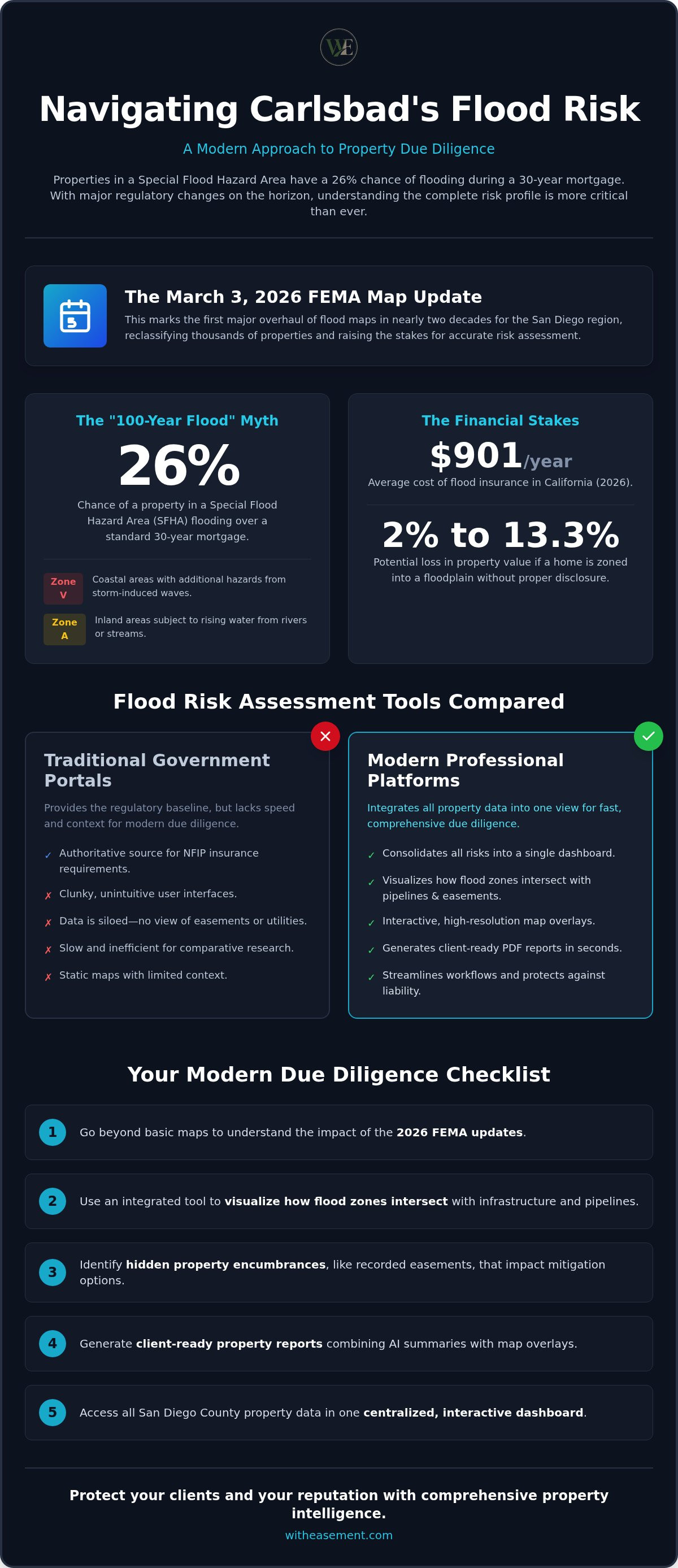
Did you know that properties in a Special Flood Hazard Area have a 26% chance of flooding during a standard 30-year mortgage? With the March 3, 2026, FEMA map update reclassifying thousands of local parcels for the first time in nearly twenty years, the stakes for accurate property research have never been higher. Most professionals still struggle with clunky, unintuitive government websites to find clear answers for their clients. You need a modern Carlsbad flood risk assessment tool that does more than just show a blue line on a static map.
It's exhausting to jump between multiple tabs while trying to explain complex environmental risks to an anxious buyer. You want to provide certainty, but hidden pipelines or overlapping easements can quickly turn a simple transaction into a liability nightmare. This guide promises to simplify that process. You'll discover how to evaluate coastal and inland hazards using professional-grade property intelligence tools that consolidate every risk into one view. We'll walk through the latest 2026 regulatory changes, show you how to visualize all property overlays on a single interactive map, and demonstrate how to generate client-ready PDF reports in seconds.
Key Takeaways
- Learn why the March 2026 FEMA map updates require a more detailed approach than simply checking a standard government website.
- Master the use of a professional Carlsbad flood risk assessment tool to visualize how flood zones intersect with critical infrastructure and pipelines.
- Discover how to identify hidden property encumbrances, such as recorded easements, that can impact a property's flood mitigation options.
- See how to generate client-ready PDF property reports that combine AI-powered summaries with high-resolution map overlays.
- Streamline your due diligence process by accessing all San Diego County property data in one centralized, interactive dashboard.
Why Traditional Flood Maps Aren't Enough for Modern Due Diligence
The March 3, 2026, FEMA map update was a massive wake-up call for the San Diego region. It marked the first major overhaul in nearly two decades, shifting thousands of properties into high-risk categories overnight. However, relying on these regulatory maps alone is a risky strategy for modern due diligence. FEMA maps are designed primarily for insurance rating, not for predicting every possible water intrusion event. Professional realtors and developers are shifting toward integrated platforms because they need to see how flood zones interact with other property encumbrances like easements or utility lines. Without this context, a simple flood line doesn't tell the whole story of a property's risk profile.
Understanding FEMA Zone Designations
The term "100-year flood" is one of the most misunderstood concepts in real estate. It doesn't mean a flood happens once a century; it means there's a 1% annual chance of occurrence. Over a 30-year mortgage, that adds up to a 26% chance of damage. Properties in Special Flood Hazard Areas (SFHA) face mandatory insurance requirements, but the specific zone matters. Zone V indicates coastal areas with additional hazards from storm-induced waves, while Zone A covers inland areas subject to rising water. A modern Carlsbad flood risk assessment tool helps you distinguish these nuances instantly. While the National Flood Insurance Program (NFIP) provides a baseline, it often lacks the granular detail needed to assess site-specific drainage or recent infrastructure changes.
The Rise of Local Vulnerability Assessments
Regulatory lines often stop where political boundaries begin, but water doesn't follow those rules. Coastal properties face unique threats like sea-level rise and bluff erosion that FEMA maps might not fully capture until years after the damage starts. Evaluating lagoon-adjacent risks is particularly critical in Carlsbad, where tidal changes and sediment buildup can alter water flow during heavy storms. Using a comprehensive flood risk assessment strategy allows you to look beyond the standard insurance zones. Localized data gives realtors a competitive edge by identifying "moderate" risk zones where insurance isn't mandatory but remains highly recommended.
The hidden cost of missing these zones isn't just a higher premium. In 2026, the average cost of flood insurance in California reached $901 per year. Properties newly mapped into high-risk zones before March 2, 2027, can access a 12-month discount window, but only if they act fast. Single-family homes zoned into a floodplain can lose between 2% and 13.3% of their value if the risk isn't disclosed and managed properly. Using a dedicated Carlsbad flood risk assessment tool ensures you don't miss these critical details, helping you protect your client's investment and your own professional reputation.
Comparing Flood Risk Assessment Tools: FEMA vs. Professional Platforms
Choosing the right Carlsbad flood risk assessment tool depends on whether you're simply verifying a policy or performing deep-dive due diligence. Most real estate professionals find themselves caught between two distinct worlds. On one side, you have the official government portals that provide the legal, regulatory baseline. On the other, you have high-tech intelligence platforms that prioritize speed, visualization, and integrated data. Understanding the strengths of each is the only way to ensure your clients aren't blindsided by hidden risks or unexpected costs during a transaction.
Government Portals: The Regulatory Baseline
The FEMA Map Service Center (MSC) remains the authoritative source for regulatory flood zones. It's essential for determining if a property requires mandatory flood insurance under the National Flood Insurance Program. Municipal planning departments in San Diego County also provide valuable localized data, often including historic flooding records and stormwater management plans. However, these tools are built for administrative accuracy, not user experience. They often require navigating through multiple clunky menus just to download a single map. These portals are excellent for final verification, but they lack the agility needed for initial property discovery or comparative research.
Professional Intelligence Tools: The Realtor's Advantage
Professional platforms change the game by focusing on the user's time. Instead of hunting through separate databases for flood zones and utility lines, you get everything in one view. Tools like the San Diego interactive property map allow you to toggle between flood risk, pipeline overlays, and recorded easements instantly. This level of integration is becoming the standard for modern Property Resilience Assessments. It allows realtors to make "no-go" decisions in minutes rather than days, protecting their time and their clients' capital. You can quickly see if an easement overlaps a flood zone, which might limit a buyer's ability to build protective retaining walls or drainage systems.
The real divide between these tools lies in reporting. Government sites give you a raw map; professional tools give you a client-ready deliverable. When a buyer asks about the $901 average annual flood insurance premium in California, you can provide an AI-summarized report that explains the specific risks for their Assessor's Parcel Number (APN). This builds immediate authority and trust. If you want to move beyond raw data and start delivering professional insights, you might find that a WithEasement membership is the missing piece of your tech stack. Having a reliable Carlsbad flood risk assessment tool at your fingertips ensures you're always the most informed person in the room.
4 Steps to Perform a Comprehensive Risk Assessment
Performing a thorough analysis requires more than a quick glance at a static map. You need a systematic workflow to uncover hidden liabilities before they become deal-breakers. Follow these four steps to get a complete picture of any parcel's environmental and legal standing using a modern Carlsbad flood risk assessment tool.
Step 1: Precise Property Identification
Accuracy begins with the right identifier. While most people start with a street address, professional due diligence relies on the Assessor's Parcel Number (APN). Addresses can be updated, duplicated, or mistakenly recorded in public databases. APN lookups eliminate data errors by anchoring the search to a unique legal identifier rather than a variable mailing address. Use parcel maps to define exact boundaries. This ensures you're analyzing the correct lot and not an adjacent property that might have different risk factors or zoning requirements.
Step 2: Layering the Data
Once you've locked in the parcel, it's time to layer information. Start by applying the latest flood zone overlays to your map. A professional Carlsbad flood risk assessment tool allows you to see exactly where the March 2026 FEMA lines cross property boundaries. Don't stop at water. Add pipeline and utility overlays to check for infrastructure conflicts that might interfere with future development. Analyzing the topography and natural drainage paths within the platform helps you predict how water will move across the site during a heavy storm event.
Step 3: Verify Recorded Easements. Even if a property sits in a high-risk zone, your ability to protect it depends on legal permissions. Check for recorded easements that might complicate flood mitigation efforts. If a utility company holds an easement over a low-lying area, you may be prohibited from building berms, drainage systems, or retaining walls. This step is critical for buyers who plan to invest in substantial property improvements or floodproofing. You don't want to discover a building restriction after the construction permits are denied.
Step 4: Generate a Summary Report. Raw data is only useful if your clients can understand it. Compile your findings into a professional PDF report for stakeholder review. These documents should include AI-powered summaries that translate complex map layers into clear, actionable insights. Providing a comprehensive view of all property risks in one document builds authority. It helps your clients move forward with confidence, knowing every potential hazard has been visualized and accounted for in the final report.
The Intersection of Flood Zones, Easements, and Infrastructure
Understanding a property's true risk profile requires looking beyond a single flood line. While a standard FEMA map shows where water might go, it doesn't show the legal or physical barriers that prevent you from managing that water. Flood risk is only one piece of a much larger property intelligence puzzle. To protect a client's investment, you must analyze how environmental hazards intersect with recorded encumbrances and underground infrastructure. A comprehensive Carlsbad flood risk assessment tool allows you to see these overlapping layers in a single view, revealing liabilities that a traditional title search might miss until it's too late.
Easements and Flood Mitigation
Recorded easements can severely limit your ability to build necessary flood defenses. Public Utility Easements (PUE) often grant utility companies the right to access underground lines, which typically means you cannot build permanent structures like retaining walls or heavy berms over them. If a property is located in a high-risk zone but is crisscrossed by utility easements, the owner may be legally prohibited from floodproofing the site. Drainage easements are even more restrictive; they are designed to facilitate the flow of water across a parcel. Any attempt to block or redirect this flow can lead to legal action from neighbors or the municipality. You can identify these hidden restrictions early by using a San Diego property easement search tool before the inspection period ends.
Pipeline Overlays and Safety
Underground infrastructure adds another layer of complexity to flood-prone areas. High-pressure gas pipelines and major water mains located within high-risk flood zones present a significant safety hazard. Flooding can lead to soil saturation and erosion, which may shift or expose these lines over time. For commercial property due diligence, these infrastructure overlays are non-negotiable. Identifying the proximity of these lines to flood-prone areas helps you assess the potential for catastrophic failure during a storm event. Disclosing these known pipeline locations to buyers is also a critical step in reducing your professional liability. It ensures the buyer understands the full scope of the property's physical environment.
Relying on separate tools for flood data and title records creates gaps in your research. Modern professionals use integrated platforms to see the full picture instantly. You can start your property search today to visualize how these complex layers interact on any parcel. Having a reliable Carlsbad flood risk assessment tool that includes pipeline and easement data ensures you never leave your clients in the dark about hidden property risks.
Streamlining Due Diligence with WithEasement Property Reports
Success in modern real estate hinges on how quickly you can turn raw data into a clear narrative. Most government reports are too technical for the average buyer, leaving them more confused than when they started. You need a way to bridge the gap between dense public records and client-ready insights. By moving beyond manual searches, a professional Carlsbad flood risk assessment tool transforms hours of archival research into an instantaneous competitive advantage. This efficiency allows you to focus on closing deals rather than decoding administrative jargon.
AI-Powered Property Summaries
Reading through dozens of recorded easements and flood maps is a massive time sink. Using AI for real estate due diligence San Diego allows you to interpret complex records in seconds. These tools act as a digital specialist, scanning documents for 'red flag' keywords that indicate building restrictions or hidden liabilities. They translate technical legal descriptions into plain English, making it easier to explain risks to your clients. This level of clarity prevents data errors and ensures that every stakeholder has a transparent understanding of the parcel’s limitations before signing a contract.
Professional PDF Deliverables
A comprehensive property risk report should be the cornerstone of your due diligence package. These reports consolidate flood zone overlays, pipeline locations, and recorded easements into a single, high-resolution document. You can use these PDF deliverables to justify offer prices or provide a solid foundation for negotiation points. If a report reveals significant encumbrances, you have the data needed to request a price adjustment or a specific repair. Beyond the transaction, providing these reports elevates your brand as a tech-forward professional who values accuracy and transparency. It proves you've done the heavy lifting to protect your client's capital.
Centralizing your property intelligence within a single membership platform saves hours of repetitive work. Instead of visiting multiple municipal websites, you access everything from a unified dashboard. The future of real estate is built on this kind of data-driven trust. When you use a high-performance Carlsbad flood risk assessment tool, you're not just buying data; you're buying certainty. This streamlined approach ensures that your due diligence is always thorough, professional, and remarkably fast. It's the most efficient way to navigate the complexities of the 2026 property market.
Navigate Carlsbad Property Risks with Confidence
Professional due diligence in 2026 requires more than a simple glance at a regulatory map. The recent FEMA updates have redefined the local landscape, making it essential to understand how water, legal boundaries, and infrastructure interact on every parcel. By moving beyond clunky government portals, you can provide the certainty your clients demand in a shifting market. You've learned how to layer environmental data with recorded easements and pipelines to uncover risks that others might miss.
Efficiency is your greatest asset. Using a modern Carlsbad flood risk assessment tool allows you to visualize these complexities instantly, turning raw records into actionable intelligence. This proactive approach doesn't just save time; it builds lasting authority with your stakeholders. You can now deliver precise, AI-powered insights that clarify even the most technical property encumbrances.
Ready to elevate your research process? Unlock professional property data with a WithEasement Membership. You'll gain access to interactive flood and pipeline overlays, AI-powered summaries, and professional PDF property reports. Take the guesswork out of your next transaction and start building a more transparent, data-driven future for your clients today.
Frequently Asked Questions
How do I find out if a specific property is in a flood zone?
You can determine a property's status by using an interactive map or a professional reporting tool. Enter the address or APN to see the current FEMA designation instantly. With the March 3, 2026, updates now in effect, it's critical to use a platform that reflects the latest parcel-level changes. These tools show exactly where a flood zone boundary crosses a property line, providing much more precision than a general neighborhood map.
What is the difference between a 100-year and a 500-year flood zone?
A 100-year flood zone has a 1% annual chance of flooding, while a 500-year zone has a 0.2% annual chance. Over a typical 30-year mortgage, a property in a 100-year zone faces a 26% chance of experiencing a flood event. Most mandatory insurance requirements apply specifically to the 100-year zone. However, the 500-year zone still represents a significant risk for properties with low-lying topography or poor drainage infrastructure.
Does a flood risk assessment tool include sea-level rise data?
Yes, advanced platforms often integrate sea-level rise and coastal erosion data alongside regulatory FEMA layers. While standard government maps focus purely on immediate insurance requirements, a professional Carlsbad flood risk assessment tool provides a more forward-looking view. This integration is vital for coastal properties where tidal changes and long-term environmental shifts can impact property value and structural integrity well before regulatory maps are eventually updated.
Can I use an APN to check for flood risk online?
Searching by Assessor's Parcel Number (APN) is the most accurate way to check for flood risk online. Addresses can sometimes be recorded incorrectly or duplicated in public databases, leading to costly research errors. Using an APN ensures the data is linked to the specific legal boundaries of the lot. This precision allows you to see exactly which portion of a parcel is impacted by high-risk flood or pipeline overlays.
Are FEMA flood maps updated every year?
No, FEMA flood maps are not updated annually; they are often revised once every decade or two. For example, the latest major update for the San Diego region went into effect on March 3, 2026, marking the first significant change in nearly twenty years. Because updates are infrequent, it's essential to use a tool that captures these once-in-a-generation shifts as soon as they become official regulatory data for the region.
What is a Special Flood Hazard Area (SFHA)?
A Special Flood Hazard Area (SFHA) is a high-risk land area subject to inundation by a flood that has a 1% or greater chance of occurring in any given year. Properties within an SFHA, often designated as Zones A or V, typically face mandatory flood insurance requirements if they have a federally backed mortgage. Understanding these designations is the first step in performing a comprehensive risk assessment for any real estate transaction.
How do pipeline overlays assist in property risk analysis?
Pipeline overlays reveal the proximity of high-pressure gas or water mains to flood-prone areas. Flooding can cause soil erosion and shifting, which increases the risk of infrastructure failure over time. By layering this data over flood zones, you can identify potential safety hazards that aren't visible on a standard title report. Disclosing these infrastructure risks helps realtors reduce professional liability and provides buyers with a more complete picture of property safety.
Why should realtors use professional property intelligence platforms over free tools?
Professional platforms offer integrated data that free tools often lack, such as recorded easements and pipeline locations. While free government sites provide a regulatory baseline, they don't show how these layers intersect or offer AI-powered summaries. Realtors use professional intelligence tools to generate client-ready PDF reports that build authority. These platforms save hours of manual research by consolidating all property-specific risks into one centralized, interactive map for faster decision-making.


