

What if the most valuable feature of your coastal property is the exact reason your building permit gets denied? It's a common frustration for realtors and developers working along the shoreline. You spend weeks researching a site only to find that coastal easement regulations are buried in fragmented public records or hidden behind dense legal jargon. Misinterpreting these descriptions doesn't just waste time; it puts your entire project at risk.
We understand that deciphering these layers of land use can feel like a full-time job. You need clarity to provide accurate advice to your clients and avoid the sting of unexpected restrictions. This guide will help you master these complexities and show you how to identify property encumbrances using WithEasement professional-grade intelligence tools. We'll explore how to visualize building envelopes, access recorded documents instantly, and generate professional reports that solidify your due diligence. By the end of this article, you'll have a clear roadmap for turning complex data into actionable property insights.
Key Takeaways
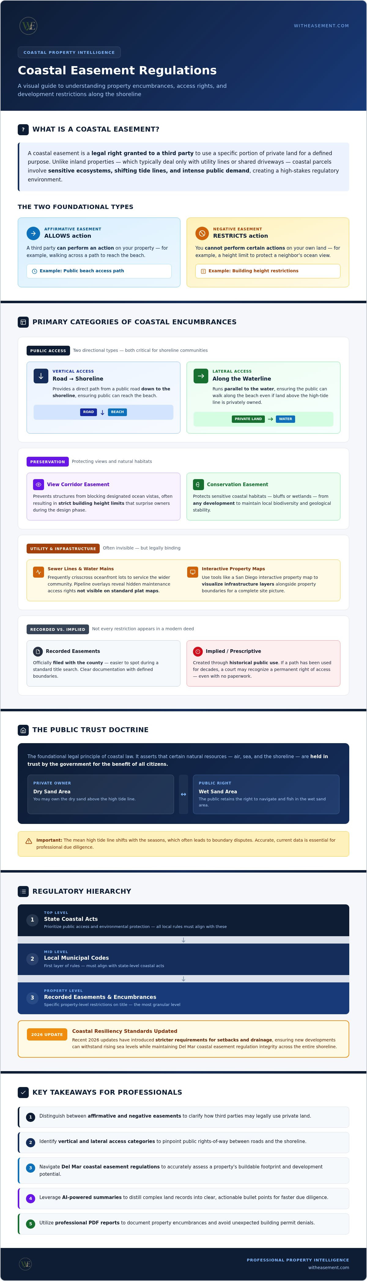
- Distinguish between affirmative and negative easements to clarify how third parties may legally use private land.
- Identify vertical and lateral access categories to pinpoint public rights-of-way between roads and the shoreline.
- Navigate Del Mar coastal easement regulations to accurately assess a property's buildable footprint and development potential.
- Leverage AI-powered summaries to distill complex land records into clear, actionable bullet points for faster due diligence.
- Utilize professional PDF reports to document property encumbrances and avoid unexpected building permit denials.
Decoding Coastal Easement Regulations and Property Rights
Coastal property ownership is often a balancing act between private exclusivity and public privilege. At its core, an easement is a legal right granted to a third party to use a specific portion of your land for a defined purpose. Understanding easement regulations and property encumbrances is vital for anyone looking to develop or purchase shoreline real estate. In the context of Del Mar coastal easement regulations, these rights usually fall into two categories. Affirmative easements allow someone else to perform an action on your property, such as walking across a path to reach the beach. Negative easements restrict what you can do on your own land, such as a height limit to protect a neighbor’s ocean view.
Why does the coast face more scrutiny than inland parcels? Inland properties usually only deal with simple utility lines or shared driveways. Coastal regions involve sensitive ecosystems, fluctuating tide lines, and intense public demand. This creates a high-stakes regulatory environment where every square inch is scrutinized by multiple agencies. A Public Access Easement is a specific legal requirement that mandates a portion of private coastal land be kept open for public use as a condition for receiving a development permit.
The Role of the Public Trust Doctrine
This legal principle forms the foundation of coastal law. It asserts that certain natural resources, like the air, sea, and shoreline, are held in trust by the government for the benefit of all citizens. This doctrine often leads to boundary disputes, as the mean high tide line shifts with the seasons. While you might own the dry sand, the public typically retains the right to navigate and fish in the wet sand area. This intersection of private ownership and public rights makes accurate data essential for professional due diligence.
Regulatory Bodies and Oversight
Managing these complexities requires a strict hierarchy. Local municipal codes provide the first layer of rules, but they don't exist in a vacuum. These ordinances must align with broader state-level coastal acts that prioritize public access and environmental protection. For example, recent 2026 updates to coastal resiliency standards have introduced stricter requirements for setbacks and drainage. These updates ensure that new developments can withstand rising sea levels while maintaining the integrity of Del Mar coastal easement regulations across the entire shoreline.
Primary Categories of Coastal Property Encumbrances
Identifying the specific type of encumbrance on a title is the first step toward understanding development potential. Del Mar coastal easement regulations categorize these restrictions based on their impact on the land and public utility. These aren't just lines on a map; they're enforceable rights that dictate exactly where you can build and where you must yield. Understanding these layers prevents costly design errors and project delays.
Public access is typically divided into two distinct directions. Vertical access easements provide a direct path from a public road down to the shoreline. Lateral access easements run parallel to the water, ensuring the public can walk along the beach even if the land above the high-tide line is privately owned. Both types are common in shoreline communities where public recreation is a high priority.
Preservation easements focus on what remains visible or untouched. View corridor easements prevent structures from blocking designated ocean vistas, often resulting in strict building height limits that surprise owners during the design phase. Conservation easements protect sensitive coastal habitats, such as bluffs or wetlands, from any development to maintain local biodiversity and geological stability.
Utility and Infrastructure Easements
Coastal zones are packed with essential infrastructure that often remains invisible to the naked eye. Sewer lines and water mains frequently crisscross oceanfront lots to service the wider community. Pipeline overlays reveal these hidden maintenance access rights that might not appear clearly on a standard plat map. You can use a San Diego interactive property map to visualize these infrastructure layers alongside property boundaries for a more complete picture of the site.
Implied vs. Recorded Easements
Not every restriction is documented in a modern deed. Recorded easements are officially filed with the county, making them easier to spot during a standard search. Implied or prescriptive easements are created through historical public use. If a path has been used by the public for decades, a court may recognize a permanent right of access even if no paperwork currently exists. AI summaries can flag mentions of these historical access rights in old land records, protecting you from unrecorded risks. Before finalizing any transaction, it's wise to pull a property easement search to ensure no hidden encumbrances threaten your investment.
The Impact of Coastal Access on Property Value and Development
Coastal property value is intrinsically linked to development potential. When Del Mar coastal easement regulations require a public path through a lot, the buildable footprint shrinks. This isn't just a minor inconvenience; it's a direct reduction in usable square footage. This limitation often sparks debates regarding the 'takings clause' of the Fifth Amendment. While the government can regulate land use, a regulation that goes too far may be considered a compensable taking. Knowing exactly where that line is drawn helps owners and developers protect their equity.
In the luxury market, a 'clean' title is a premium asset. High-end buyers pay for privacy and exclusivity. If a property is encumbered by public access rights, its marketability in the elite tier can fluctuate. Additionally, modern due diligence must account for how flood risk overlays interact with these restricted zones. If an easement pushes your home site closer to a flood-prone area, your insurance premiums and structural requirements will spike. Visualizing these overlapping risks is essential for a realistic valuation and long-term planning.
Building Envelope Restrictions
The building envelope defines the area of a lot where construction is legally permitted. Coastal setbacks already limit this space, but easements can constrict it even further. We're seeing a shift in 2026 toward 'managed retreat' strategies. These regulations limit shoreline armoring like sea walls, forcing new builds to sit further back. When combined with existing Del Mar coastal easement regulations, the remaining buildable land might be much smaller than the total lot size suggests.
Due Diligence for Coastal Real Estate Professionals
Failing to disclose a lateral or vertical access easement can lead to significant liability for realtors. It's not enough to rely on general disclosures; you need specific, documented proof. Professional property reports during the escrow period provide this security. They ensure that all parties understand the limitations before the deal closes. For those managing multiple listings, using a San Diego property easement search streamlines the research workflow and provides the professional-grade data required for high-stakes transactions. This level of transparency builds trust and prevents the unexpected permit denials that can kill a sale.
Step-by-Step: How to Locate Recorded Easements Online
Finding recorded encumbrances used to require a trip to the county recorder's office or a deep dive into archaic municipal archives. Today, you can access this data in seconds. The process begins with precise identification. Once you've located the parcel, you can layer technical data to see how Del Mar coastal easement regulations manifest on the ground. This digital workflow replaces hours of manual research with instant, visualized results.
Follow this streamlined process to ensure your due diligence is professional and thorough:
- Locate the target property using the Assessor’s Parcel Number (APN) for maximum accuracy.
- Log into a centralized property data platform to pull current recorded maps.
- Apply map overlays for pipelines, flood zones, and HOAs to identify overlapping risks.
- Generate an AI summary report to distill complex legal descriptions into clear, actionable insights.
Using APN for Precise Identification
Street addresses in beach communities can be surprisingly unreliable. House numbers might change over decades, or a single address might cover multiple distinct units. The APN is a permanent, unique identifier that links directly to the legal history of the land. It's the gold standard for researching Del Mar coastal easement regulations and other title restrictions. For split parcels or new multi-unit coastal developments, the APN ensures you're looking at the correct recorded map rather than an outdated version. Cross-referencing this number with historical plat maps allows you to verify the exact dimensions of any recorded access rights before you commit to a design.
Visualizing Overlays and Hazards
A recorded easement rarely exists in isolation. You often find 'stacked' encumbrances, where a public access path sits directly over a municipal sewer line or near a high-pressure gas main. Seeing these layers simultaneously is crucial for evaluating development risk. When you layer environmental hazards like flood zones over these easements, you get a realistic view of the actual building envelope. Professional PDF reports allow you to package these findings into a single, authoritative document for clients or lenders. This clarity reduces friction during the escrow process and builds confidence in your professional advice. Start your next search by securing a WithEasement Membership to access instant property intelligence.
Streamlining Property Intelligence with AI and Professional Tools
Manual title searches are a relic of the past. In fast-moving coastal markets, waiting days for a title clerk often means losing a deal to a more agile buyer. Instant digital intelligence changes the game entirely. It allows you to visualize Del Mar coastal easement regulations and other encumbrances before you even step foot on the property. This shift from physical archives to digital dashboards empowers realtors to act with the speed of a tech startup and the authority of a seasoned specialist.
AI summaries perform the heavy lifting of reading hundreds of pages of recorded documents. They extract key bullet points, ensuring you don't miss a vital restriction buried in legal jargon. Centralizing HOA data and easement records in one place removes the friction of jumping between fragmented government portals. The WithEasement Membership serves as the definitive solution for this modern research workflow. It provides the high-tech utility needed to navigate complex land use data without needing a law degree or professional intermediary.
The Power of AI-Generated Summaries
Reading through a pile of land records is a significant drain on your time. AI technology identifies critical clauses in easement documents, such as maintenance responsibilities or expiration dates. This is a massive time-saver for realtors managing multiple listings simultaneously. You get the insights you need in seconds rather than hours. To learn more about how this works, explore our guide on AI for real estate due diligence San Diego. It details the specific ways machine learning is transforming property research.
Generating Professional PDF Reports
A comprehensive property report is more than just a list of facts. It's a tool for building trust with potential buyers and lenders. These reports include recorded maps, AI-generated summaries, and clear visualizations of encumbrances like pipelines or flood zones. By the 2026 standard, digital due diligence is no longer optional; it's a baseline requirement for coastal real estate. Presenting a professional PDF report shows stakeholders that you've done the heavy lifting. It proves the property's value and protects everyone involved from the sting of unexpected building permit denials.
Master Your Coastal Property Intelligence
Success in the shoreline market depends on your ability to visualize what isn't immediately visible. You've learned how to distinguish between access categories and identify the hidden infrastructure that dictates a lot's true value. Navigating Del Mar coastal easement regulations no longer requires manual record digging or guesswork. By leveraging modern data layers, you can protect your clients from building permit denials and secure your professional reputation as an expert facilitator.
Efficiency is the new standard for real estate due diligence. You can now access AI-powered easement summaries, interactive maps with pipeline and flood overlays, and professional PDF property reports in a single dashboard. Don't let fragmented public records slow your momentum or hide critical encumbrances. Unlock professional property data with a WithEasement Membership to transform raw land records into actionable insights. Take control of your property research and move forward with total confidence in your data.
Frequently Asked Questions
What is the difference between a public access easement and a private right-of-way?
Public access easements are legal rights granted for general public use, such as a path connecting a road to the shoreline. These are often mandated by coastal commissions as conditions for development. In contrast, a private right-of-way is a specific agreement between neighboring property owners. It grants access only to designated individuals or parcels, such as a shared driveway, and doesn't allow the general public to enter the land.
Can a coastal easement be removed or terminated once it is recorded?
Terminating a recorded easement is a complex legal process that typically requires the consent of all involved parties or a specific court order. If the easement was granted to a government body for public access, removal is extremely rare. It usually involves proving the original purpose is no longer viable or the easement was abandoned. Most coastal restrictions are permanent encumbrances that stay with the land through every subsequent sale.
How do I find out if a coastal property has hidden pipeline easements?
You can identify hidden infrastructure by using a property data platform with specialized overlays. While standard title reports list legal rights, interactive maps showing pipeline and flood overlays provide a visual representation of where these lines actually cross the lot. This clarity is essential for avoiding accidental damage during excavation. It allows you to see the exact location of recorded utilities before any construction or landscaping begins on the site.
What happens if I build a structure on an existing coastal easement?
Building on an easement without express permission usually leads to a mandatory demolition order at the owner's expense. The easement holder retains the legal right to access that specific area at any time. Any permanent structure that interferes with that right is considered an illegal encroachment. This often results in building permit denials, heavy fines, or litigation that can stall a property sale during the due diligence period.
How does the Mean High Tide Line affect coastal property boundaries?
The Mean High Tide Line often serves as the legal boundary between private land and public trust tidelands. Because this line shifts due to erosion and sea-level changes, your actual buildable area can fluctuate over time. Navigating Del Mar coastal easement regulations requires monitoring these ambulatory boundaries to ensure your development remains on private land. This ensures you comply with public access mandates while protecting your property's long-term value and structural integrity.
Are HOA regulations different from municipal coastal easement regulations?
Yes, HOA regulations are private contractual agreements between homeowners, while municipal regulations are public laws. An HOA might restrict your landscaping or exterior aesthetics, but coastal easement regulations govern public access and environmental protection. You must comply with both layers of oversight to avoid legal challenges. Using a centralized platform to perform HOA searches alongside easement research ensures you have a complete picture of all active property restrictions.
How can AI help me understand complex property deed language?
AI-powered summaries can distill hundreds of pages of dense legal jargon into clear, actionable bullet points. These tools identify critical clauses regarding access rights, maintenance duties, and restrictions often buried in historical records. This technology allows realtors to interpret complex land use data instantly without needing specialized training. It's an efficient way to uncover how Del Mar coastal easement regulations might impact a specific parcel's development potential or marketability.
Where can I get a professional PDF property report for a coastal parcel?
Professional PDF property reports are available through a WithEasement Membership. These documents consolidate recorded easement data, HOA details, and flood risk information into an authoritative format for stakeholders. Using these reports ensures that realtors provide high-level transparency during the escrow process. They serve as a vital tool for documenting property encumbrances and protecting all parties from the risks of hidden land use restrictions that could impact a sale.


