

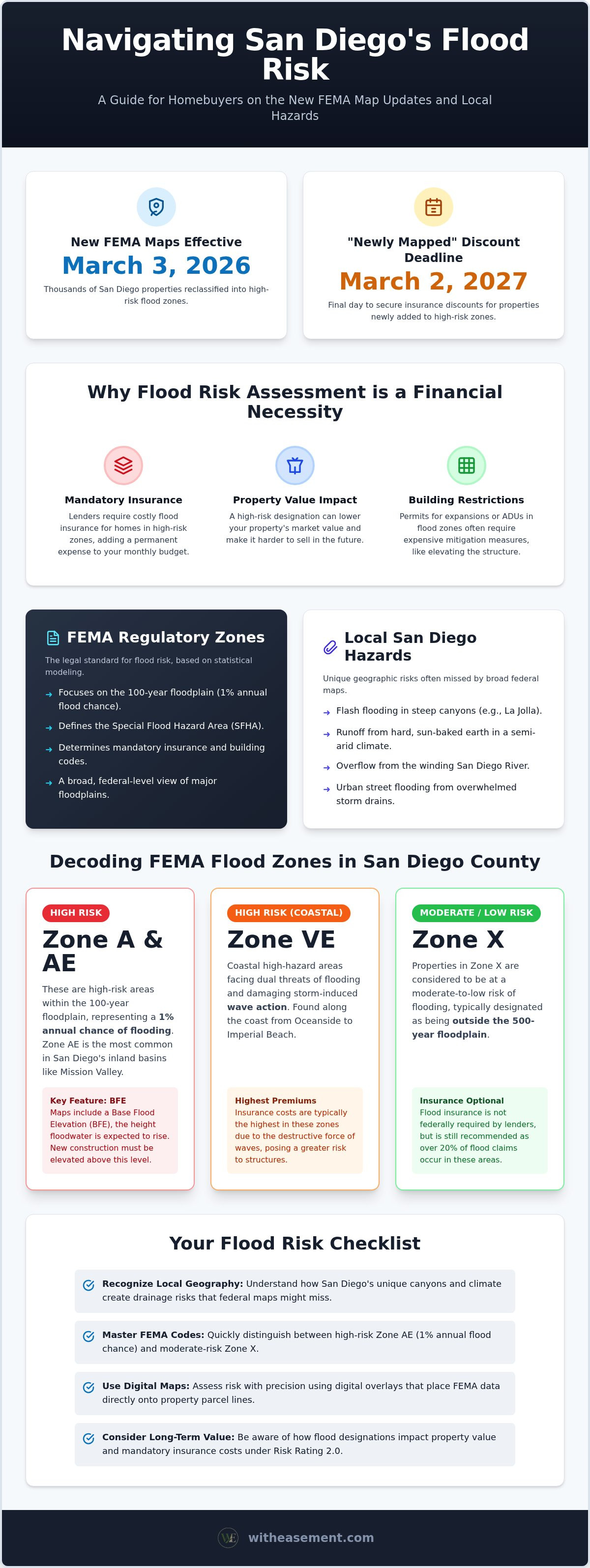
The FEMA map update on March 3, 2026, reclassified thousands of San Diego properties into high-risk flood zones for the first time in twenty years. In our region, flood risk is a matter of specific topography, moving from the steep canyons of La Jolla to the winding San Diego River. It's natural to feel overwhelmed by technical acronyms or the fear of rising insurance premiums. You shouldn't have to guess whether your home is vulnerable to the next major weather event.
This guide shows you how to assess property flood risk San Diego without the typical friction found in government portals. You will learn to navigate the latest maps and interpret local geography to determine your home's precise risk level. We will explain how the "newly mapped" insurance discount works before the March 2, 2027, deadline and how these designations affect your property value. This is your roadmap to clear, actionable data that puts you back in control of your home's financial safety.
Key Takeaways
- Recognize how San Diego’s unique canyon topography and semi-arid climate can mask significant drainage risks that standard federal maps might overlook.
- Master the FEMA coding system to quickly distinguish between high-risk Zone AE basins and moderate-risk areas.
- Follow a clear, step-by-step process to assess property flood risk San Diego using precise parcel boundaries and current digital overlays.
- Identify how specific flood designations impact your long-term property value and mandatory insurance obligations under Risk Rating 2.0.
- Consolidate your research by accessing flood, easement, and HOA data through a single interface rather than toggling between multiple government portals.
What Does Property Flood Risk Mean in San Diego?
Flood risk is the statistical probability of a property experiencing inundation within a specific timeframe. In San Diego, this risk is often misunderstood. Our semi-arid climate creates a false sense of security for many buyers who only see dry creek beds and sun-drenched hillsides. However, the region's geography is designed to move water quickly from the mountains to the coast. A foundational step in understanding flood events is recognizing that "dry" doesn't mean "safe." When heavy rains hit our hard, sun-baked earth, the water doesn't soak in; it runs off instantly into low-lying basins.
You must assess property flood risk San Diego as a standard part of your real estate due diligence. This isn't just a safety precaution. It's a financial necessity. Failing to identify a flood-prone parcel early can lead to unexpected costs that surface only days before your loan is set to fund. Professional risk assessment divides these threats into two categories: federal regulatory zones and local geographic hazards.
Why Flood Assessment is Essential for Buyers
A thorough assessment protects your investment from several angles. First, it determines whether your lender will require mandatory flood insurance. If the home sits in a high-risk zone, this premium becomes a permanent part of your monthly carrying costs. Second, flood risk directly impacts future property value. Modern buyers are data-savvy. A property with a history of inundation or a high-risk FEMA designation may stay on the market longer or command a lower price. Finally, these zones influence your ability to improve the land. Building permits for ADUs or kitchen expansions often require expensive mitigation measures if the structure's footprint sits within a designated hazard area.
The Difference Between FEMA Zones and Local Risk
Federal regulatory zones and local geographic hazards are not always the same. FEMA maps focus on the 100-year floodplain, which represents the area with a 1% annual chance of flooding. While these maps are the legal standard, they don't capture every threat. San Diego's topography creates unique drainage patterns that federal data might miss. Flash flooding in steep canyons or urban street flooding from overwhelmed storm drains often occurs outside of federal zones. The Special Flood Hazard Area (SFHA) is the primary regulatory threshold used to determine mandatory insurance and building restrictions. Understanding this distinction ensures you don't overlook localized risks that a broad federal map might miss.
Understanding FEMA Flood Zones in San Diego County
FEMA uses a specific letter-based shorthand to categorize flood vulnerability. These codes tell you if a property sits in a Special Flood Hazard Area (SFHA) or a lower-risk buffer. To accurately assess property flood risk San Diego, you must decode these designations before committing to a purchase. While the March 3, 2026, map update moved many parcels into higher-risk categories, the underlying definitions remain the same.
- Zone A and AE: High-risk areas with a 1% annual chance of flooding.
- Zone VE: Coastal high-hazard areas subject to wave action.
- Zone X: Moderate-to-low risk areas, often designated as being outside the 500-year floodplain.
Zone AE and the 100-Year Floodplain
Zone AE is the most common high-risk designation in San Diego's inland basins. These areas are mapped with a defined Base Flood Elevation (BFE). The BFE is the height to which floodwater is anticipated to rise during a 100-year storm. Mission Valley serves as the city's primary example of Zone AE due to its proximity to the San Diego River. If you plan to build or renovate in this zone, local regulations require elevating the lowest floor above the BFE. This often adds significant engineering costs to a project, making early identification vital for your budget.
Coastal High Hazard Areas (Zone VE)
Beachfront properties from Oceanside down to Imperial Beach often fall into Zone VE. These areas face the dual threat of rising water and velocity from storm-induced waves. Insurance premiums in these zones are typically the highest in the county because wave action causes more structural damage than standing water. Long-term assessments must also account for sea level rise impacts on local infrastructure. As the shoreline shifts, properties currently in moderate zones may eventually be reclassified into these high-hazard coastal tiers.
Visualizing Zones with a San Diego Interactive Property Map
Static federal maps can be difficult to read when you're looking for a specific house. Digital overlays simplify the process by placing FEMA data directly over high-resolution parcel lines. You can use a San Diego interactive property map to see exactly where a flood line crosses a property boundary. This level of detail is essential when a backyard is in a flood zone but the home's footprint is not. To get a clear picture of how these zones interact with other land constraints, consider a WithEasement membership to access comprehensive property reports in seconds.
Local San Diego Geographic Factors That Increase Risk
San Diego’s topography creates unique drainage patterns that federal maps often miss. Our region is a network of mesas, steep canyons, and coastal bluffs. While FEMA maps provide a solid baseline, they don't always capture the specific way water moves through our local landscape. Dry doesn't mean safe. To accurately assess property flood risk San Diego, you must look beyond the colored lines on a federal chart and evaluate the physical land itself.
Urbanization plays a significant role in modern flood risk. In older neighborhoods, "impervious surfaces" like concrete driveways, paved alleys, and rooftop expanses prevent rainwater from soaking into the ground. This leads to rapid urban street flooding even during moderate storms. Coastal erosion is another shifting factor. A property's risk profile can change in a single decade as the shoreline retreats or sea levels rise, potentially exposing inland parcels to new hazards.
The Mission Valley Flood Corridor
Mission Valley is the county's most recognizable flood corridor. Historically, the San Diego River reclaimed this entire valley floor during major rain events. While modern developments use sophisticated drainage systems and underground vaults, the underlying risk remains high. The March 3, 2026, FEMA map revision specifically targeted this area, moving many properties from low-risk Zone X into higher-risk categories. Understanding your flood risk in San Diego requires looking at these historical patterns. Even if a building is elevated, the surrounding roads and infrastructure may still be vulnerable to total inundation.
Canyon and Hillside Runoff Risks
Steep terrain in neighborhoods like La Jolla, North Park, and Clairemont accelerates water flow. During extreme weather, these canyons act as natural funnels for runoff. The danger isn't just rising water; it's the velocity of the flow and the potential for debris flows or mudslides. A property labeled as "low risk" on a federal map can still suffer significant damage if it sits at the base of a steep slope. Federal models prioritize rising river water or coastal surges, but they often overlook the torrential sheet flow that hits San Diego hillsides during atmospheric river events. Always check the elevation of the parcel relative to the surrounding canyon walls.
How to Perform a Step-by-Step Risk Assessment
Performing a thorough due diligence process doesn't require a degree in hydrology. To accurately assess property flood risk San Diego, you need to move beyond general zip code data and look at the specific parcel level. Start by identifying the property using its Assessor’s Parcel Number (APN). While a street address is a good starting point, APN-based searches provide higher accuracy because they link directly to the legal boundaries recorded by the county. This ensures you aren't looking at a neighbor's risk profile by mistake.
Using Modern Tools for Instant Visualization
Ditch the confusing paper maps and outdated government portals. Modern GIS platforms allow you to overlay current FEMA flood layers directly onto high-resolution parcel boundaries. This dynamic approach lets you toggle between different risks, such as flood zones and pipeline overlays, in a single view. You can see instantly if a flood line clips a corner of the backyard or if it sits directly under the primary structure. Seeing these layers interact provides a level of clarity that a standard PDF report simply cannot match.
Evaluating Insurance Implications
Once you've identified the zone, your next move is to contact an NFIP-participating agent. If the property is an older San Diego home, ask about 'Grandfathering' rules. These rules might allow you to keep a lower risk rating if the home was built before the current maps were in place. If the premiums seem high, consider obtaining an Elevation Certificate. This document, prepared by a licensed surveyor, provides the exact height of your home relative to the Base Flood Elevation. It often serves as the most effective tool for lowering your annual insurance costs.
Consulting Expert Records
Flood risk isn't just about where the water comes from; it's about where it goes. You should perform a San Diego property easement search to find recorded drainage rights. These records identify public utility easements that dictate how water must move off-site. In HOA-managed communities, check for recorded maintenance agreements that outline who is responsible for clearing storm drains or maintaining bioswales. Identifying these legal constraints early prevents future disputes over water damage and maintenance costs. To assess property flood risk San Diego with total confidence, use WithEasement to pull a comprehensive property report and verify every risk factor in one click.
Simplify Your Due Diligence with WithEasement
Traditional property research is a fragmented process. You typically start at a FEMA portal, move to the County Assessor for parcel boundaries, and then dig through City records for drainage easements. WithEasement eliminates this friction by centralizing San Diego County land records into a single, intuitive platform. You can assess property flood risk San Diego with a few clicks rather than a few hours of manual searching. By combining high-resolution parcel data with official flood layers, we provide the clarity needed for rapid due diligence.
Our platform is built specifically for San Diego professionals who value their time. You no longer need to jump between city, county, and federal websites to get a complete picture of a single property. We bring the data to you, organized and ready for analysis.
The Power of Integrated Map Overlays
Visualization is the key to understanding environmental hazards. Our interactive map allows you to overlay flood zones and pipeline data directly onto property lines. You can see exactly where a Zone AE designation ends and a safe building site begins. This level of detail is critical for identifying buildable area on a lot or determining if an existing structure is truly vulnerable. You can visualize gas pipelines and easements alongside environmental risks, ensuring you see the full intersection of legal and geographic constraints on your screen. It’s a faster, more intuitive way to handle complex site assessments.
AI-Powered Property Summaries
Complex land records are often buried in dense, 50-page legal documents that take hours to parse. Our AI summaries perform the heavy lifting for you by extracting the most relevant data points in seconds. You can identify 'red flags' in flood or easement documentation instantly without reading every line of a preliminary title report. This empowers you to make faster, data-driven decisions on high-stakes property investments. Whether you're checking for a recorded maintenance agreement or a specific flood-proofing requirement, the platform highlights the facts that matter most to your bottom line.
When your research is finished, you can download professional PDF reports. These documents combine flood risk, easements, and HOA data into a cohesive package that is easy to share with lenders, clients, or partners. It’s a complete property intelligence tool designed to help you assess property flood risk San Diego with total confidence. To get started, sign up for a WithEasement membership and unlock instant access to San Diego's most comprehensive property data.
Protect Your Property with Local Intelligence
Understanding the intersection of federal regulations and local geography is the only way to truly protect your home. You've seen how San Diego’s unique terrain, from the steep canyons of North Park to the river basins of Mission Valley, creates risks that standard maps might miss. Staying updated on the March 3, 2026, FEMA map revisions ensures you aren't caught off guard by mandatory insurance requirements or future resale hurdles. Knowledge of your specific flood zone isn't just about safety; it’s about preserving your property's long-term equity.
You now have the framework to assess property flood risk San Diego with the same precision as industry professionals. By moving away from frustrating government portals and adopting integrated digital tools, you gain immediate clarity on any parcel in the county. It's about replacing confusion with actionable intelligence that fits your schedule. You don't need to be a GIS expert to uncover hidden land constraints when the right data is at your fingertips.
Unlock professional property risk reports with a WithEasement Membership. Gain instant access to Interactive San Diego Flood Overlays, AI-Generated Property Insights, and our robust PDF Report Generator. Take the guesswork out of your due diligence and secure your investment with confidence.
Frequently Asked Questions
Is flood insurance mandatory in San Diego?
Flood insurance is mandatory if your property sits within a Special Flood Hazard Area (SFHA) and you carry a mortgage from a federally regulated lender. This requirement applies to high-risk zones like AE or VE. Even without a federal mandate, some private lenders require coverage to protect their investment. If you own your home outright, insurance is optional but highly recommended to protect your equity from unexpected weather events.
How do I find out if my San Diego home is in a 100-year flood zone?
You can find your specific designation by entering your address into a local property intelligence tool or the FEMA Map Service Center. To accurately assess property flood risk San Diego, look for designations starting with the letters A or V. These indicate a 1% annual chance of flooding, commonly known as the 100-year flood zone. Digital overlays provide the most precise view by showing exactly where these boundaries intersect with your parcel lines.
What is a FEMA flood map and how often is it updated?
A FEMA flood map, or Flood Insurance Rate Map (FIRM), is the official document used to determine flood insurance requirements and premium rates. These maps don't follow a fixed update schedule but undergo revisions when new data or physical changes occur. San Diego County recently saw a significant Physical Map Revision that took effect on March 3, 2026. This update impacted thousands of properties, particularly along the San Diego River and coastal regions.
Can I build on a property located in a San Diego flood zone?
Building is permitted in most flood zones, provided you follow strict local and federal mitigation requirements. You must typically elevate the lowest floor of new structures above the Base Flood Elevation (BFE) or use specific flood-resistant materials. In San Diego, these projects require professional engineering certifications and must meet rigorous safety standards. Always check with the local building department to ensure your design complies with the current regulations for your specific flood designation.
Do I need flood insurance if I'm in Zone X?
You aren't legally required to purchase flood insurance in Zone X, but it’s often a wise financial decision. Zone X represents areas of moderate-to-low risk, yet a significant portion of flood insurance claims come from outside high-risk zones. In San Diego, flash floods and urban drainage issues can cause damage in areas that federal maps label as low risk. Premiums for Zone X are typically much lower, providing affordable protection against localized flooding.
How does flood risk affect property values in San Diego County?
High flood risk can negatively impact property values by increasing the total cost of ownership through high insurance premiums. Buyers often factor these recurring costs into their offers. Additionally, strict building restrictions in high-risk zones can limit a property's potential for expansion or renovation, making it less attractive to some investors. Conversely, a property that has been successfully remapped out of a high-risk zone often sees a boost in marketability and buyer interest.
Where can I find a San Diego pipeline and flood overlay map?
You can access integrated pipeline and flood overlays through a specialized property intelligence platform like WithEasement. Traditional government sites often separate this data into different portals, making it difficult to see how they overlap. A centralized map allows you to assess property flood risk San Diego alongside gas pipelines, easements, and HOA boundaries in a single view. This comprehensive approach is essential for thorough due diligence and identifying potential conflicts before a purchase.
What is the difference between a flood zone and a flood plain?
A floodplain is a physical geographic area of low-lying land near a water source that is naturally subject to flooding. In contrast, a flood zone is a specific regulatory designation created by FEMA to determine insurance rates and building requirements. While the floodplain describes the land's natural state, the flood zone dictates the legal and financial obligations of the property owner. You can live in a geographic floodplain without being in a high-risk regulatory flood zone.


