

Spending thousands of dollars on a professional land survey might be the most unnecessary expense you face this year. While physical markers are important, they don't always reveal the hidden legal rights that can stop a San Diego construction project in its tracks. You need to know if a utility company has a claim to your backyard before you pour concrete, not after.
It's understandable to feel overwhelmed by complex legal descriptions and the high costs of local surveying services. You want clear answers about property boundaries and pipeline locations without waiting months for a specialist to show up. Understanding the nuances of an easement search vs land survey San Diego is the first step toward saving time and protecting your investment. This article clarifies the critical differences between digital records and physical surveys to help you determine which one you actually need. We'll compare the speed, cost, and specific outcomes of both methods so you can unlock the data you need with total confidence.
Key Takeaways
- Understand the core difference between legal usage rights and physical property markers to determine which professional service your project requires.
- Compare the costs and timelines of an easement search vs land survey San Diego to save time and budget on your next real estate transaction.
- Identify "invisible" property restrictions like utility pipelines and flood zones instantly using modern digital map overlays.
- Recognize the specific legal triggers, such as boundary disputes or land subdivisions, that make a physical land survey unavoidable.
- Streamline your property research by generating comprehensive PDF reports that summarize complex San Diego County records in seconds.
Understanding the Fundamental Difference: Records vs. Physical Boundaries
Property research in San Diego often feels like a puzzle with missing pieces. You might know where your fence sits, but do you know who has the legal right to access that specific strip of land? This is the core of the easement search vs land survey San Diego debate. While they are related, they serve two entirely different functions in your due diligence process. One deals with the law, while the other deals with the land.
An easement search is a deep dive into the paper trail. It identifies the legal rights granted to third parties, such as utility companies or neighbors, to use a portion of your land. In contrast, a land survey is a physical act. It involves a licensed professional walking your property to locate and mark boundaries on the actual ground. San Diego property owners often confuse these two during the building permit process. They might assume a survey shows everything, but a surveyor only marks what is physically there or legally described in a plat. They don't necessarily interpret the complex language of a recorded document from decades ago that grants a "floating" easement to a gas company. Knowing What is an Easement? is essential before you break ground on a new project.
Official county records are managed by different departments. One department typically maintains parcel maps for tax purposes, while another is responsible for holding the actual deeds and recorded agreements. If you only look at a parcel map, you are only seeing half the story.
What is a San Diego Property Easement Search?
This process involves the digital retrieval of recorded documents from the official county records repository. Instead of looking at the dirt, you are looking at the data. By using an Assessor’s Parcel Number (APN), you can uncover "invisible" restrictions that don't appear on a standard map. Using a San Diego property easement search allows you to find hidden encumbrances like conservation easements or private access rights. These digital records provide the legal framework that dictates how you can use your property.
What is a Professional Land Survey?
A land survey is a physical inspection performed by a licensed professional land surveyor. These experts place monuments or stakes to define property corners with high precision. As of February 23, 2026, new ALTA/NSPS standards require improved precision and clearer documentation for these surveys. The result is usually a plat map or a record of survey filed with the local government department responsible for surveys. While a survey is the gold standard for resolving boundary disputes, it is often the most expensive and time-consuming part of the research process.
The Role of a San Diego Property Easement Search
A digital search reveals what the naked eye cannot see. While a physical survey marks the dirt, an easement search explores the legal layers beneath it. This is where you find the "invisible" restrictions that can halt a project before it starts. Many San Diego realtors rely on preliminary title reports; however, these documents often lack the specific map visuals or technical details found in a direct easement search. Performing a digital audit helps reduce easement disputes by identifying potential conflicts early in the due diligence phase.
The primary advantage of a digital-first approach is speed. You can verify property rights in minutes rather than weeks. When comparing an easement search vs land survey San Diego, the search serves as your early warning system. It tells you if you have a "floating" easement or a specific utility corridor that requires a setback. Modern tools now use AI summaries to interpret dense legal language in San Diego land records. This technology strips away the jargon and provides a clear explanation of who can access the property and for what purpose.
Identifying Pipeline and Utility Overlays
Standard parcel maps are notoriously thin on utility data. In regions like North County and East County, high-pressure natural gas and water pipelines often crisscross residential lots. Building a structure or even a heavy fence over these lines is a liability. Understanding the easement search vs land survey San Diego dynamic helps you decide if you need to pay for a physical site visit or if a digital overlay provides enough clarity for your project. WithEasement visualizes these risks using interactive map overlays that show exactly where these lines run. You can see the proximity of underground infrastructure to your proposed building site without waiting for a surveyor to locate markers.
Checking HOA and Flood Zone Data
Easement searches often intersect with other property restrictions. For example, an HOA might have specific access rights that aren't strictly classified as public utility easements. A unified property intelligence report combines these records with environmental data. You can assess property flood risk San Diego alongside your easement check to get a complete picture of the land's limitations. This comprehensive view ensures that no hidden encumbrance or environmental hazard goes unnoticed during the listing process. If you want to see all these layers in one place, you can start your property search to unlock instant data for any San Diego address.
When a Physical Land Survey Becomes Mandatory
Digital records provide the legal framework, but they can't hammer a stake into the ground. There are specific moments in a San Diego real estate transaction where the easement search vs land survey San Diego decision is made for you by law or necessity. While an easement search tells you what is allowed, a physical survey confirms what is actually happening on the terrain. If you are dealing with a hostile neighbor or a strict city building inspector, you need a licensed professional on-site to verify the physical reality of the land.
Boundary Disputes and Encroachments
Imagine your neighbor installs a new driveway that clearly encroaches two feet onto your lot. A digital record proves your ownership, but it doesn't resolve the physical trespass. In these cases, a professional land surveyor provides the legally defensible evidence required for San Diego Superior Court. They place physical monuments, often iron pipes or lead and tack markers, that serve as the gold standard for resolving disputes. These markers leave no room for interpretation during mediation. If a structure already exists on an easement, the survey identifies the exact square footage of the encroachment, which is vital for negotiating an easement vacation or a settlement.
Subdivision and Construction Requirements
Development projects require absolute precision. If you plan to subdivide a large parcel in East County or North County into multiple lots, the City of San Diego demands a certified plat. You cannot guess where a foundation goes. A few inches of error can lead to a code violation or a costly encroachment on a utility setback. Once the survey is complete, the professional must file a Record of Survey with the County. As of July 15, 2026, the County of San Diego Department of Public Works charges a $711 review fee for the first sheet of these maps. This official filing ensures your new boundaries are recognized by the government and future owners.
Purchasing high-value commercial real estate also triggers mandatory survey requirements. Most lenders require an ALTA/NSPS Land Title Survey to issue title insurance. Following the updated February 23, 2026 standards, these surveys provide the highest level of detail for lenders. They identify every physical improvement, utility connection, and potential easement issue on the site. While a digital search is the best starting point for residential research, these complex commercial transactions demand the exhaustive physical data that only a boots-on-the-ground survey provides.
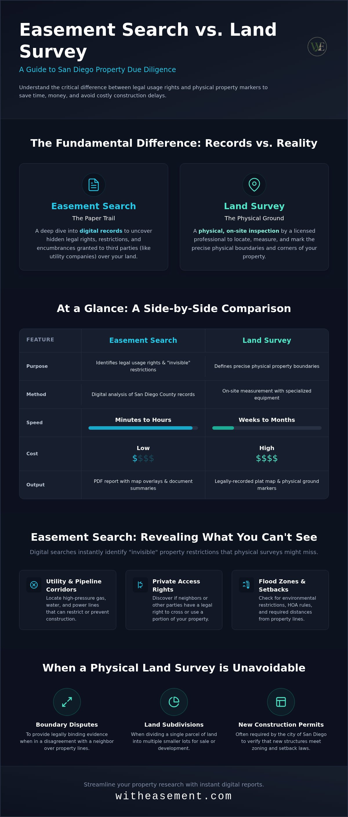
Easement Search vs. Land Survey: A Side-by-Side Comparison
Choosing between an easement search vs land survey San Diego depends entirely on your project's phase. A digital search provides immediate legal clarity for a fraction of the cost of a physical inspection. While a professional land survey for a platted lot can range from $1,200 to $4,000 for ALTA standards, a digital report identifies recorded restrictions instantly. You receive PDF copies of actual recorded documents rather than waiting for someone to drive out and pound stakes into the ground. Surveys remain the only choice for construction or court cases; however, for listing prep and due diligence, digital data is usually sufficient.
- Speed: Instant digital access vs. a 3-6 week lead time for San Diego surveyors in 2026.
- Deliverables: Searchable PDF records and map overlays vs. physical boundary markers and plat maps.
- Primary Use: Verifying rights before a sale vs. defining boundaries for a foundation or fence.
The "Search First" Strategy for San Diego Realtors
Savvy agents use a "search first" approach to protect their clients' budgets. Identifying a major utility easement before the appraisal can save a deal from collapsing at the eleventh hour. You can use a San Diego interactive property map during your initial walkthrough to spot potential red flags. If the map shows a high-pressure gas line running directly under a proposed ADU site, you can advise your client to consult a surveyor immediately. This prevents them from wasting weeks on a project that the City will never approve.
Cost-Benefit Analysis for Homeowners
Spending $2,000 on a full land survey for a simple storage shed is often overkill. Most basic permit inquiries only require proof of recorded easements and setbacks. A professional property report often satisfies these initial requirements without the need for a licensed surveyor to visit the site. Spending $50 on a search provides a 50x return on investment compared to a $2,500 survey when you only need to verify that a structure doesn't encroach on a neighbor's access. If you need to verify your property rights right now, access your property report today and skip the month-long wait for a surveyor.
Streamlining Your Due Diligence with WithEasement
Traditional property research is slow, manual, and often confusing. You shouldn't have to wait weeks for a surveyor or spend hours digging through fragmented government portals. WithEasement centralizes San Diego County land records into one intuitive platform. It bridges the gap between raw data and actionable intelligence. This efficiency is why thousands of local real estate professionals use the service to accelerate their due diligence. When evaluating an easement search vs land survey San Diego, this tool provides the legal context you need before you commit to the high cost of physical markers.
The platform acts as a transparent facilitator. It takes the heavy lifting out of organizing public records. You get immediate access to the same high-level data used by developers, but without the technical barriers. It's a modern solution for a modern market. You can verify property rights, check for encumbrances, and review environmental risks from your desk. This "digital-first" approach ensures that your time is spent closing deals rather than chasing paperwork.
Searching by Address or APN
Finding specific property data is now as simple as typing an address. You can search by street address or Assessor’s Parcel Number (APN) to pull recorded documents instantly. The process is straightforward. Enter the location and unlock a comprehensive view of the parcel's history. The platform allows you to visualize pipeline and flood zone overlays in a single, interactive view. You can see exactly where a high-pressure line crosses a lot without needing a site visit. You also get immediate access to HOA data. This eliminates the need to spend days calling management companies or tracking down elusive board members for basic restriction info.
Empowering Your Property Decisions
Uncertainty kills real estate deals. You need to move from curiosity to insight in under 60 seconds to stay competitive. The platform generates professional PDF property reports that you can share directly with clients or buyers. These reports serve as a reliable foundation for your property intelligence. They include AI-powered summaries that translate dense legal descriptions into plain English. You'll understand the scope of a utility right-of-way or a conservation easement without needing a law degree. Having this professional data during negotiations gives you a distinct advantage. It allows you to address potential deal-breakers with facts rather than guesses. You can provide your clients with the clarity they deserve while protecting your professional reputation. Start your San Diego property search with WithEasement today.
Master Your San Diego Property Research
Success in the San Diego real estate market depends on your ability to access accurate data quickly. You now understand the critical distinctions of an easement search vs land survey San Diego. While a physical survey is indispensable for construction and legal boundary disputes, a digital easement search is the most efficient way to clear early due diligence hurdles. It reveals the hidden rights that can derail a transaction before you ever need to pound a stake into the ground.
You don't have to navigate complex public records alone. By leveraging San Diego County focused data and AI-powered record summaries, you can identify pipeline and flood overlays in seconds. This modern approach empowers you to make confident decisions without the typical wait times or high costs of traditional methods. Unlock instant San Diego property data with a WithEasement membership. Take control of your property intelligence and start exploring today.
Frequently Asked Questions
Can I find my property lines online for free in San Diego?
You can view general parcel maps through the San Diego County Assessor’s website, but these aren't legally binding for boundary disputes. These maps are designed for property tax assessment and often lack the precision needed for construction. For exact lines, you'll need to hire a professional surveyor to find physical monuments or use recorded maps to estimate your boundaries.
Is an easement search the same as a title search?
An easement search is a focused investigation into specific usage rights, whereas a title search covers the broader history of ownership, liens, and mortgages. When comparing an easement search vs land survey San Diego, the search identifies the legal paperwork while the survey marks the ground. Digital easement reports often include interactive overlays that provide more visual clarity than a standard title report's text-heavy descriptions.
How much does a land survey cost in San Diego County in 2026?
Basic residential surveys in San Diego for 2026 typically range from $292 to $1,101 depending on the lot's age and size. If you require a comprehensive ALTA survey for a larger or more complex parcel, costs can increase significantly. These fees cover the professional's field work, technical research, and the official filing of the Record of Survey with the County Surveyor.
Do I need a survey to build a fence in San Diego?
The City of San Diego doesn't always require a survey for a standard fence permit, but it's a vital safeguard against future legal trouble. Building a fence even a few inches over a property line can lead to expensive removal orders or neighbor disputes. A survey provides the only legally defensible proof of where your fence should stand to avoid encroaching on adjacent lots.
What happens if a land survey contradicts a recorded easement?
Recorded legal documents usually hold priority over physical improvements or older markers found during a survey. If a survey shows a structure is built within a recorded easement area, the easement holder typically retains the legal right to access that area. Understanding the easement search vs land survey San Diego distinction helps you identify these legal risks before you invest in physical markers or new construction.
How do I find utility easements on my property in San Diego?
You can locate utility easements by searching recorded documents at the County Recorder’s office using your APN or address. Many homeowners find that digital platforms offer a much faster way to visualize these "invisible" lines. These tools use interactive overlays to show gas, water, and electrical lines that might not be physically marked on your property but are legally recorded.
Can I use a WithEasement report for a building permit application?
A WithEasement report is an excellent tool for preliminary research and site planning during the early stages of a permit application. While the City of San Diego often requires a certified plat map from a licensed surveyor for the final submission, the report identifies critical setbacks and easements. This data helps you design your project correctly before paying for expensive professional surveying services.
How long does it take to get a land survey done in San Diego?
You should plan for a lead time of roughly three to six weeks for most local surveyors in 2026. Professional backlogs and the detailed research required at the County Recorder’s office contribute to these timelines. While a digital search provides instant data for your due diligence, the physical process of locating historical monuments and marking corners requires significant field time and technical precision.


