

What if a single hidden pipe under your backyard could legally halt your renovation project tomorrow? It's a common nightmare for property owners who rely on outdated paper records or word-of-mouth. If you're currently performing a San Diego utility easement search, you've likely realized that government GIS portals are often clunky and difficult to interpret. You shouldn't have to wait days for a title report just to see where a sewer line runs.
We understand that property research feels like a chore when you're stuck deciphering complex legal descriptions and grainy plat maps. You deserve instant access to the facts without the technical headache. This guide promises to simplify the process by showing you exactly how to locate recorded utility easements using modern digital platforms. We'll explore how to access visual overlays of utility lines, use AI to summarize dense documents, and generate professional PDF reports that provide total property clarity in minutes.
Key Takeaways
- Distinguish between recorded and unrecorded easements to understand the legal rights affecting your land use.
- Streamline your San Diego utility easement search by using Assessor Parcel Numbers to access precise municipal records.
- Overcome the frustration of fragmented data by aggregating information from multiple digital repositories into one view.
- Visualize hidden risks instantly with interactive maps that feature pipeline and flood zone overlays.
- Generate professional PDF property reports and AI-powered summaries to simplify complex legal descriptions for stakeholders.
Understanding Utility Easements and Why Digital Access Matters
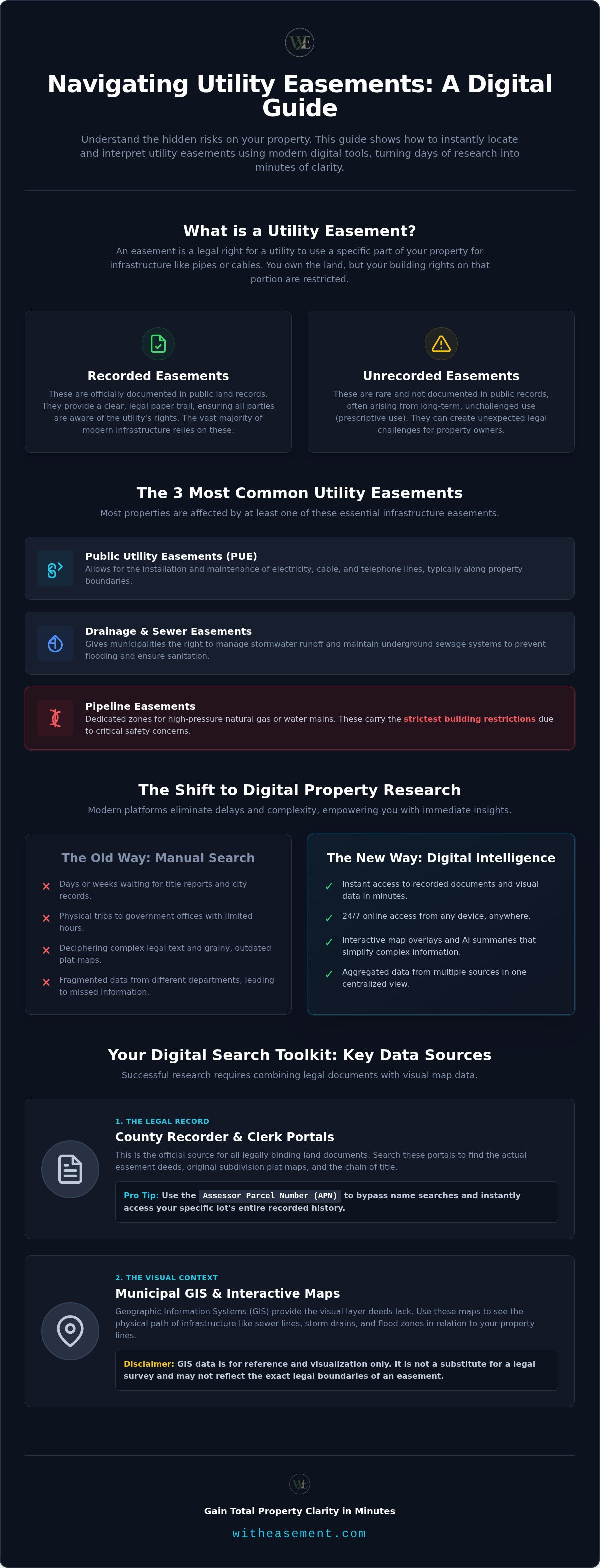
A utility easement is a legal encumbrance that grants a specific entity, like a power company or city department, the right to access a portion of your property. You retain the title, but your ability to build or plant in that zone is restricted. If you're initiating a San Diego utility easement search, you're likely trying to verify these boundaries before a renovation or purchase. Missing these details can lead to forced demolition of structures built on top of active lines.
Recorded easements are documented in public land records, providing a clear paper trail for anyone doing their due diligence. Unrecorded easements are rarer but can occur through prescriptive use; however, most modern infrastructure relies on recorded documents. Traditionally, finding these required a trip to a government building to sift through microfilm. Digital retrieval has changed the game, turning a multi-day process into a few clicks. This shift empowers property owners to take control of their data without waiting for a third-party intermediary.
The Most Common Types of Utility Easements
Most properties have at least one of these three easement types, each serving a distinct purpose for community infrastructure:
- Public Utility Easements (PUE): These typically allow for the installation and maintenance of electricity, cable, and telephone lines.
- Drainage and Sewer Easements: These give municipalities the right to manage stormwater runoff and maintain underground sewage systems.
- Pipeline Easements: These are dedicated zones for high-pressure natural gas or water mains. They often carry the strictest building restrictions due to safety concerns.
Why Real Estate Professionals Prioritize Online Searches
Efficiency is the primary driver for the move to digital property intelligence. Real estate agents and developers use online tools to gain an immediate advantage during the due diligence phase. By moving away from "City Hall" searches, you eliminate the friction of office hours and administrative delays. A San Diego utility easement search that used to take three business days now happens in seconds.
- Instant Identification: Spotting a major gas line overlay early can save a deal from collapsing during the inspection period.
- Visual Mapping: Modern platforms replace the need to read confusing metes and bounds descriptions with clear, interactive map overlays.
- Document Integrity: Accessing digital repositories ensures you're viewing the most current recorded documents without the risk of human error during a manual search.
This level of accessibility means you don't need specialized training to understand where your property rights end and utility rights begin. It's about having the right information at the right time to make confident decisions.
The 3 Primary Digital Repositories for Utility Easement Records
Locating the right data requires checking three distinct digital silos. Each repository serves a specific purpose, but they rarely communicate with one another. When you perform a San Diego utility easement search, you'll find that the legal truth is often split between deed text and visual maps. Understanding where to look first prevents wasted hours on the wrong website.
County Recorder and Clerk Portals
The County Recorder or Assessor's office is the official custodian of all land-related legal instruments. This is where you find the actual easement deeds that bind your property. Most portals allow you to search the Grantor/Grantee index. This index lists the names of parties involved in the original easement agreement. To speed up your lookup, always have your Assessor Parcel Number (APN) ready. This unique identifier allows you to bypass name-based searches and go straight to your lot's history. You should also look for plat maps. These drawings show the original subdivision of land and often mark the location of utility strips along property lines.
Municipal GIS and Interactive Maps
Geographic Information Systems (GIS) provide the visual context that deeds often lack. Most local jurisdictions maintain public interactive maps where you can toggle specific data layers. These tools are excellent for seeing the physical path of underground infrastructure. You can use the Layer List feature to visualize several types of lines:
- Sewer and Water: Main lines and lateral connections maintained by the city.
- Storm Drains: Culverts and catch basins that handle runoff.
- Public Rights of Way: Areas where the city maintains access for future expansion.
Keep in mind that GIS data is for reference only. It isn't a legal survey. While professional analysts often download shapefiles from these portals for technical work, a GIS map can be off by several feet. Always verify the visual data against the recorded deed found at the County Recorder's office.
The third repository is the utility company itself. Large providers for gas, electricity, or telecommunications maintain private maps through their Land Services or Right of Way departments. They track specialized infrastructure, like high-pressure pipelines, that may not appear on municipal GIS sites. The fragmentation between these three sources is the biggest challenge in property research. To avoid missing a critical detail, consider using a property easement search platform that pulls these disparate records into a single, unified view.
How to Conduct a Utility Easement Search Online: A Step-by-Step Guide
Don't rely on phone calls or office appointments to find property data. Modern research happens at your desk. A successful San Diego utility easement search begins with data organization. You need to gather specific identifiers before diving into digital portals. This ensures you're looking at the right parcel and not a neighboring lot with similar features. Following a logical sequence prevents you from getting lost in fragmented municipal databases.
Step 1: Locating the Assessor Parcel Number
Street addresses are often imprecise in land records. The Assessor Parcel Number (APN) serves as the primary digital key for every property in the region. You'll find this identifier on your property tax bill or by searching a digital assessor map. Using the APN eliminates the risk of retrieving the wrong documents. It's the most accurate way to link a physical location to its legal history. For a deeper look at how this identifier connects to broader data sets, check out this San Diego property report by APN.
Step 2: Navigating Interactive Map Overlays
Once you have your APN, access a municipal or professional GIS portal. These maps allow you to layer different types of data over a satellite view of your lot. Look specifically for Pipeline Overlays to identify high-pressure gas or water mains that might cross your building footprint. You can also toggle layers for sewer laterals and flood zones to see how they interact with existing structures. Utilizing a San Diego interactive property map provides the visual clarity needed to spot potential development hurdles early.
After checking the maps, cross-reference your findings with a preliminary title report. This document lists all recorded encumbrances that a title company has discovered during their search. However, title reports often use dense legalese that's hard to visualize. To wrap up your search, verify everything through a centralized property intelligence platform. This final step ensures that the visual map data matches the legal descriptions found in the recorded deeds. It gives you a complete, reliable picture of the property's constraints without the need for specialized training.
Overcoming Common Challenges in Digital Property Research
Roadblocks happen even with a targeted San Diego utility easement search. Public records often live in separate municipal silos. One portal might host sewer data while another handles gas mains. This lack of coordination creates dangerous data gaps. You shouldn't have to piece together a puzzle just to see if you can build a deck. Identifying these hurdles early is the first step toward a successful property intelligence workflow.
Decoding Complex Legal Descriptions
Easement deeds are written in a dense, archaic style that's difficult for non-specialists to parse. You'll frequently encounter terms like "Ingress/Egress," which simply refers to the right to enter and exit the property. "Right-of-Way" defines the specific path allowed for utility access. "Appurtenant" means the easement stays with the land, regardless of the current owner. Deciphering a 20-page deed manually is a massive time sink. Modern platforms use AI to distill these documents into three or four actionable bullet points. This tech clarifies your legal obligations instantly. Explore the benefits of AI for real estate due diligence to see how it streamlines the review process.
Identifying Hidden Pipeline Risks
Standard title searches often miss the specific path of utility infrastructure. They might record the existence of an easement but fail to show where a high-pressure gas line actually sits. This is a major liability for buyers during a short escrow period. You don't have the luxury of time for a full manual survey. Use specialized overlays to visualize gas, oil, or hazardous liquid lines directly on your property map. This turns invisible risks into clear, visual data points before you commit to a purchase.
Sometimes digital records are missing or the scans are too grainy to read. When this happens, you must look for "as-built" plans. These are the final drawings submitted after the utility was installed. They often vary from the original recorded deeds because contractors frequently adjust paths based on field conditions. Verifying the recorded deed against an as-built plan is the only way to be certain of a line's exact location. If you want to eliminate the guesswork and access unified property data, start a property easement search now.
WithEasement: Streamlining Your Property Intelligence Workflow
Traditional property research is often a fragmented mess. You shouldn't have to toggle between county portals and municipal GIS maps just to find a single sewer line. WithEasement solves this by providing centralized access to recorded easements, HOA data, and critical infrastructure layers in one interface. It's the professional alternative to clunky government sites. Your San Diego utility easement search becomes a streamlined experience rather than a multi-day administrative hurdle. You gain an immediate visual understanding of the land through interactive maps that feature proprietary pipeline and flood zone overlays.
A Single Source of Truth for Realtors
Real estate professionals need results now. Closing a deal requires identifying red flags before the inspection period ends. By consolidating disparate data sources, WithEasement eliminates the need for multiple browser tabs and complex logins. A San Diego property easement search that once took hours now takes seconds. This speed allows you to provide clients with total data transparency. You build trust through immediate, verifiable insights. It's about empowering your team with high-level data that was previously locked behind specialized training or slow government processes.
Professional Reporting Tools for Due Diligence
Interpretation is just as important as discovery. Our AI-powered property summaries do the heavy lifting by scanning dense legal records for you. They highlight critical encumbrances, so you don't miss a high-pressure gas line or a restrictive flood zone overlay. When you're ready to share your findings, generate a professional PDF property report with a single click. These reports are fully customizable. You can include the specific data layers relevant to your project, from pipeline paths to HOA boundaries. You meet every professional standard of due diligence without the manual labor of traditional research.
This tool acts as your knowledgeable local specialist, organizing complex information so you can focus on making confident investment decisions. It bridges the gap between dense public records and the end-user. You get the clarity you need without the friction of traditional administrative barriers. Stop waiting for title reports and start unlocking property intelligence instantly with a membership designed for modern real estate workflows.
Unlock Instant Property Intelligence
You now have the roadmap to move past clunky government portals and long waiting periods. Real estate due diligence is no longer about sifting through grainy scans or making endless phone calls. By utilizing digital repositories and interactive maps, you can identify hidden infrastructure before it impacts your project or purchase. A successful San Diego utility easement search relies on connecting disparate data layers into one clear, visual view.
Don't let fragmented records slow down your next deal. You can access centralized easement data instantly and generate professional PDF reports for your clients without the manual hassle. Use our AI-powered summaries to interpret complex land records in seconds. Start your property easement search with WithEasement today and take full control of your property research. You've got the tools; now it's time to use them with confidence.
Frequently Asked Questions
How do I find utility easements on my property online?
You can find recorded easements by searching the County Recorder’s official website using your property’s legal description. Most jurisdictions provide digital portals where you can look up specific deeds and plat maps. For a more comprehensive view, professional property platforms aggregate these records alongside interactive maps. This allows you to see both the legal text and the visual path of the easement without visiting a government office in person.
Can I see the exact location of utility lines on a map?
Yes, you can visualize utility lines using Geographic Information Systems (GIS) maps provided by your local municipality. These maps allow you to toggle layers for sewer, water, and storm drains. However, standard GIS data is often for reference only and may lack precision. Specialized pipeline overlays provide more accurate visual data for high-pressure lines, which is critical for ensuring safety during any excavation or construction project on your lot.
What is the difference between a utility easement and a right-of-way?
A utility easement grants a specific company the right to use a portion of your land for infrastructure like power lines. You still own the property title. A right-of-way is a more specific type of easement that typically allows for public passage or the placement of major thoroughfares. While both restrict your land use, a right-of-way often carries more significant limitations on your ability to build or fence the affected area.
Are all property easements recorded in public digital databases?
Most modern utility easements are recorded and accessible through digital land records. However, older easements or those created through prescriptive use might not appear in a standard online search. This is why a comprehensive San Diego utility easement search should include both a review of recorded deeds and a check of historical plat maps. If a record is missing digitally, you may need to consult as-built plans from the specific utility provider.
How do I look up easements using an Assessor Parcel Number (APN)?
To look up easements using an APN, enter the unique number into the search field of your local County Recorder or Assessor’s digital portal. The APN acts as a direct link to all recorded documents associated with your specific lot. This method is far more accurate than searching by street address. Once you access the parcel history, look for documents titled Easement Deed or Grant of Easement to see specific utility restrictions.
Can I build a fence or structure over a recorded utility easement?
Building over a recorded easement is generally prohibited because it blocks essential access for utility companies. If you install a fence or shed over a sewer line, the municipality has the legal right to remove it at your expense for repairs. You should always check the specific language of the easement deed first. Some agreements allow for temporary structures, but most require the zone to remain clear of any permanent obstructions or deep-rooted landscaping.
What information is included in a professional property easement report?
A professional report includes a list of all recorded easements, interactive map overlays, and AI-powered summaries of legal documents. It provides clear visual data on where pipelines, flood zones, and sewer lines cross your property. These reports often include high-resolution PDF exports that you can share with contractors or clients. Having this data in one centralized document eliminates the need to cross-reference multiple government websites and ensures you don't miss hidden encumbrances.
How often are online property and easement records updated?
Update frequency varies by jurisdiction, but most county recorders digitize new documents within a few business days of recording. Municipal GIS maps might be updated less frequently, sometimes on a quarterly or annual schedule. This is why it’s vital to compare the visual map data with the most recently recorded deeds. Professional property intelligence tools often pull the latest available data to ensure your San Diego utility easement search is based on the most current information.


