

Could a single overlooked easement or a hidden pipeline overlay derail your next real estate deal? For many professionals, the fear of missing a critical land risk is a constant source of stress. You've likely spent entire afternoons jumping between government websites just to compile a basic property data PDF report. You know the frustration of deciphering complex legal descriptions while the clock is ticking on a closing. It's time to replace manual digging with automated intelligence.
This guide teaches you how to generate professional, client-ready documents that consolidate recorded easements, HOA details, and flood zones instantly. You'll learn how to use AI-powered summaries to unlock complex data and visualize property overlays with total clarity. We're moving beyond fragmented research to a faster, more reliable way of performing due diligence. By the end of this article, you'll have the tools to streamline your workflow and uncover hidden risks before they become expensive problems.
Key Takeaways
- Understand how a professional property data PDF report centralizes fragmented public records into a single, actionable document for faster decision-making.
- Uncover hidden property constraints including recorded easements and HOA details without the need for manual, time-consuming research.
- Use interactive map overlays to visualize high-risk factors like pipelines and flood zones directly on your screen.
- Translate dense legal easement language into clear insights using AI-powered summaries that save hours of interpretation.
- Generate polished, client-ready reports instantly using just an address or APN to demonstrate professional authority in every meeting.
What is a Property Data PDF Report?
A property data PDF report is a centralized intelligence document that combines recorded easements, tax history, and environmental risk overlays into a single, portable file. It serves as a vital bridge between fragmented public records and actionable real estate intelligence. Instead of wrestling with disorganized government portals, you get a cohesive summary of a specific land parcel's legal and financial status. This document is the cornerstone of a modern due diligence process, ensuring no hidden encumbrance or environmental threat goes unnoticed before a transaction closes.
The Evolution of Property Research
Property research used to mean spending hours at city hall, waiting for clerks to pull physical maps or flipping through heavy binders of tax records. The digital age moved these records online, yet it often left them scattered across dozens of disconnected county and state portals. You might find tax data on one site, flood maps on another, and easement documents buried in a third. This fragmentation creates a massive time sink and increases the risk of human error.
Today, the industry is shifting toward integrated data platforms that aggregate these disparate sources into a single view. While interactive maps offer great visual exploration, the PDF format remains the professional standard for portability and clarity. It provides a permanent record you can attach to an email, present in a client meeting, or include in a disclosure package. It's a reliable snapshot in time that ensures everyone involved in a deal is looking at the same verified information.
Who Needs Professional Property Reports?
Reliable property intelligence is essential for anyone navigating the complexities of land ownership or sales. Accessing a property data PDF report levels the playing field, giving you the same depth of insight once reserved for high-end title companies or specialized legal teams.
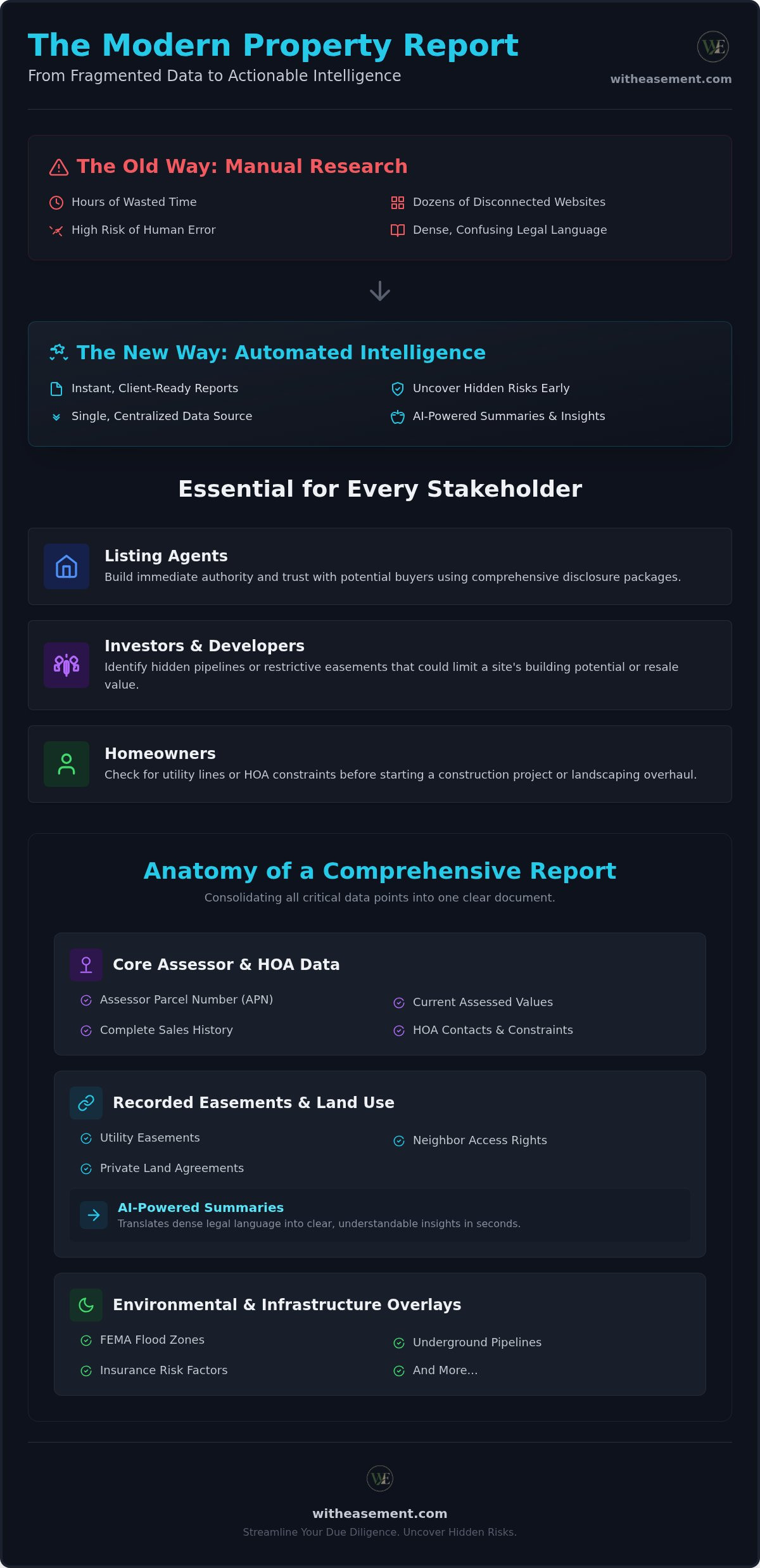
- Listing Agents: Prepare comprehensive disclosure packages that build immediate authority and trust with potential buyers.
- Investors and Developers: Identify hidden pipelines or restrictive easements that could limit a site's building potential or resale value.
- Homeowners: Check for utility lines or HOA constraints before starting a construction project or landscaping overhaul.
Having this data at your fingertips reduces the friction of research. It allows you to move with confidence, knowing that the most critical details about a parcel are already organized and ready for review. This approach values your time and focuses on delivering value quickly without unnecessary barriers.
Essential Components of a Comprehensive Property Report
A comprehensive property data PDF report does more than just list the owner's name. It layers legal, financial, and environmental data to create a full picture of the land's potential. To build a complete profile, you need specific components that traditional title searches might overlook. This professional document ensures you have every critical detail in one place before moving forward with a deal.
Start with the core assessor data. Every report must include the Assessor Parcel Number (APN), current assessed values, and a clear sales history. This data helps you verify the financial standing of the parcel before you dig deeper into the legal complexities. You should also look for HOA information, including management contact details and specific association constraints that could impact how the land is used or developed.
Decoding Recorded Easements and Land Use
Easements are often the most misunderstood part of due diligence. You must differentiate between utility easements, access rights for neighbors, and private agreements. A utility company might have the right to dig on your lawn, or a neighbor might have a legal path through your driveway. These details are often buried in dense legal jargon within federal land records or county filings.
Using AI summaries simplifies this process. Instead of reading pages of "legalese," you get a plain-English explanation of who has the right to use the land. This clarity is essential. An undisclosed easement can tank a property's value or prevent you from building that planned extension. Understanding these rights early in the process saves time and prevents legal headaches later.
Environmental and Infrastructure Overlays
The surface of the land rarely tells the whole story. You need to visualize what's underneath and around the property. Risk overlays are critical for identifying factors that influence insurance costs and safety. A professional property data PDF report should include the following datasets:
- Flood Zones: Determine if expensive flood insurance is mandatory for the parcel.
- Underground Pipelines: Locate gas or water lines using 2026 data sources to avoid catastrophic excavation errors.
- Seismic Risks: Understand the geological stability of the area before investing in infrastructure.
Interactive map layers allow you to toggle these features on and off for immediate visual insights. This visual approach helps you spot risks that a text-only report might miss. If you want to see these details for yourself, you can generate an instant report to verify any parcel's infrastructure. It turns raw data into a strategic tool for negotiation and risk management.
Manual Research vs. Automated PDF Report Generation
Manual research is a marathon. Traditionally, uncovering land details meant navigating a maze of city hall departments and physical records. You might start at the tax assessor's office and end up at the public works department just to find a single pipeline location. This method is slow. It's prone to error. Most importantly, it's exhausting. It relies on your ability to find the right person at the right desk, which isn't a scalable way to run a real estate business.
When you rely on manual portals like the Real Property Data Search, you're responsible for connecting the dots yourself. Information is fragmented across different sites, increasing the risk of missing a critical easement or an updated flood zone. An automated property data PDF report changes this dynamic. It aggregates verified public data into a single view in about 60 seconds. You trade four to six hours of manual digging for one minute of automated precision. This shift doesn't just save time; it ensures that your data is sourced from verified, updated records without the risk of human oversight.
The High Cost of Incomplete Due Diligence
Missing a single detail during due diligence can lead to a legal nightmare. Imagine a buyer discovering a hidden utility easement after they've already broken ground on a new pool or home extension. These disputes often land on the realtor's desk, creating liability and damaging professional reputations. Professional reports act as a shield. They ensure that HOA constraints and land use data are disclosed upfront, leaving no room for expensive surprises. By providing a comprehensive property data PDF report, you protect your business and your clients from post-sale legal disputes.
Workflow Integration for Modern Realtors
Efficiency is the ultimate competitive advantage. Modern agents don't wait for a title company to send back basic info; they lead with data. You can easily add these reports to your digital listing presentations to show sellers you've done the homework. It demonstrates a level of preparation that wins listings and builds immediate authority.
During buyer consultations, use these reports as a high-value takeaway. They build instant trust. Instead of making vague promises about a property's potential, you provide transparent, data-backed analysis. You become the knowledgeable specialist who values the client's time and safety. This tech-forward approach streamlines your workflow and positions you as an indispensable partner in every transaction.
How to Generate and Interpret Your Property Report
Generating a comprehensive property data PDF report is a streamlined process designed for speed. You don't need a law degree to unlock these insights. The workflow follows a logical progression from raw data entry to professional output, ensuring you spend less time digging and more time making decisions. It's about moving from curiosity to a client-ready document in just a few clicks.
- Step 1: Enter the property address or Assessor Parcel Number (APN) to identify the specific land parcel.
- Step 2: Review the interactive map layers to visualize flood zones, pipelines, and property boundaries instantly.
- Step 3: Utilize AI tools to scan and summarize complex recorded documents like easements or HOA bylaws.
- Step 4: Export your findings into a professionally formatted property data PDF report for your records or client presentations.
Searching by APN vs. Street Address
While a street address is the most common starting point, it isn't always the most accurate. Public record databases can be sensitive to typos, directional prefixes, or outdated naming conventions. If an address doesn't return immediate results, switching to the Assessor Parcel Number (APN) is the professional choice. Think of the APN as a social security number for the land. It provides a unique, permanent fingerprint that ensures you're looking at the exact parcel you intend to research without any ambiguity.
Handling these variations requires a flexible approach to data entry. If you're working in areas with complex record systems, you can find advanced search techniques in our specialized guides to help navigate tricky databases. Mastering both search types ensures you never hit a dead end during your due diligence process.
Reading Between the Lines of an AI Summary
AI interpretation bridges the gap between dense legal text and actionable intelligence. It scans hundreds of pages of recorded documents to find specific keywords related to maintenance obligations or restrictive covenants. This is a massive advantage for high-volume investors who need to triage dozens of properties a week. Instead of reading every line, you get a plain-English snapshot of the most critical details.
You should use these summaries as a high-level guide rather than a final legal opinion. Always verify the AI-generated insights against the original recorded document, which is conveniently included in your report. Look for red flags like "exclusive use easements" or "undisclosed HOA fees" that could impact your bottom line. This dual-verification method combines the speed of tech with the reliability of original sources. If you want to streamline your next project, you can start your property search now and see these summaries in action.
Streamlining Due Diligence with WithEasement Professional Reports
Centralizing property intelligence doesn't have to be a multi-step chore. WithEasement brings every critical data layer into a single, accessible membership. You no longer need to juggle separate subscriptions for flood maps, pipeline data, or HOA records. Instead, you get a unified platform built for speed and professional clarity. This centralized approach allows you to generate a high-quality property data PDF report that serves as the definitive record for any transaction.
Leveraging AI for real estate due diligence saves you hours of manual work. The platform doesn't just find the data; it helps you interpret it. You can customize every report with specific overlays for flood zones and underground pipelines based on your client's needs. This level of detail builds professional authority and ensures you never walk into a meeting unprepared. It turns raw public records into a strategic advantage for your business.
The WithEasement Advantage for Professionals
Independent professionals often lack the high-end data tools available to major title companies. We bridge that gap by offering instant access to data layers that usually require expensive, fragmented subscriptions. Our professional PDF formatting is designed specifically for real estate workflows, ensuring your reports look as polished as they are accurate. You can see how these tools come together by reviewing our AI for San Diego Real Estate Due Diligence: 2026 Guide, which demonstrates the platform's ability to handle complex parcel data with ease.
The PDF format is more than just a document; it's a portable asset. You can attach it to digital listing presentations or hand it to a buyer during a consultation. It provides a clear, visual summary of the land's potential and its risks. This professional presentation helps you stand out in a crowded market where speed and accuracy are the primary currencies of trust.
Getting Started with Your First Report
Setting up your membership is the first step toward unlimited property searches. Once you're inside, you can start running reports by address or APN immediately. Use these documents to win more listings by showing sellers you have a deep understanding of their land's specific constraints. They also help you close faster by addressing buyer concerns before they become deal-breakers. You aren't just selling a house; you're selling a verified, low-risk investment.
Transparency is your best sales tool. When you provide a comprehensive property data PDF report, you remove the guesswork for your clients. You become the tech-forward innovator who values their time and protects their investment. It's a simple change to your workflow that yields immediate results in efficiency. Start generating professional property data PDF reports today.
Elevate Your Real Estate Due Diligence
Transitioning from fragmented manual searches to an integrated, tech-forward approach changes how you do business. You've seen how centralizing recorded easements, HOA details, and environmental risk overlays into a single document eliminates the guesswork of traditional research. By utilizing a professional property data PDF report, you save hours of administrative digging and protect yourself from hidden liabilities. It's about working smarter, not harder.
Professional clarity is now within reach for every real estate specialist. You can lead every meeting with confidence, backed by data that is easy to visualize and even easier to explain to your clients. Stop jumping between disconnected government portals. Start using a tool designed for modern workflows that values your time and your reputation. You have the power to uncover every hidden detail before it becomes a deal-breaker.
Generate your professional property data PDF report with WithEasement to access AI-powered property summaries, comprehensive easement and HOA data, and professional, client-ready PDF exports. Unlock the full potential of your land research and start closing deals with total transparency today.
Frequently Asked Questions
What is included in a standard property data PDF report?
A standard report includes Assessor Parcel Number (APN) details, assessed land values, and recent sales history. It also features recorded easements, HOA management details, and interactive map overlays for flood zones or pipelines. These components provide a 360-degree view of the parcel's status. Having all this information in one document allows you to perform due diligence without visiting multiple government websites or departments.
Can I generate a property report using only an APN?
Yes, you can generate a complete report using just the Assessor Parcel Number (APN). In fact, searching by APN is often the preferred method for professionals because it identifies the exact parcel without the ambiguity of street address variations. If a property has a complex address or is part of a recent subdivision, the APN ensures you pull the correct records. This precision helps you avoid pulling data for the wrong lot during the research phase.
How accurate are the easement records in these reports?
Easement records are sourced directly from verified public filings and recorded documents. While these reports provide high-level accuracy based on the most recent available data, you should always review the original recorded document attached to the report. This dual-verification approach ensures you understand the specific legal language of the easement. It's a reliable way to identify utility rights, neighbor access, or private agreements that could impact land use or future construction.
Does the report include HOA contact information and bylaws?
Yes, the report uncovers HOA management details and association constraints. You'll find contact information for the management company or association board, which is essential for verifying current dues or pending assessments. While some reports provide summaries of bylaws, others include the specific recorded covenants that govern the property. This data allows you to advise clients on architectural restrictions or community rules before they commit to a purchase or a building project.
Is a property data report the same as a title search?
No, a property data report is a due diligence tool used for research and risk assessment, while a title search is typically performed by a title company for insurance purposes. These reports focus on providing instant access to easements, HOA data, and environmental risks that a standard title search might not highlight as clearly. It's an indispensable partner for early-stage investigation, helping you spot potential red flags before you pay for more expensive, formal title services.
How does the AI summary feature help with property records?
The AI summary feature translates dense legal descriptions into plain English. It scans recorded easements and HOA documents to extract key information like maintenance responsibilities or usage restrictions. This tool is designed to reduce the friction of interpreting complex documents, saving you hours of manual reading. It allows you to quickly identify the most important details of a property data PDF report without needing specialized legal training or professional intermediaries.
Can I share these PDF reports directly with my clients?
Yes, these reports are designed to be client-ready and professional. You can export the findings into a polished PDF format that is perfect for digital listing presentations or buyer consultations. Sharing a property data PDF report builds immediate trust by showing that you've done the heavy lifting of organizing information. It positions you as a knowledgeable specialist who values transparency and provides data-backed insights to help clients make informed real estate decisions.
What environmental risks are typically covered in the overlays?
Environmental overlays typically cover flood zones, underground pipelines, and seismic risks. These visual layers allow you to see hidden features of the land that aren't visible during a physical walk-through. You can identify if a property requires expensive flood insurance or if a high-pressure gas line runs through a planned building site. Using these 2026 data sources ensures you have the most current intelligence to manage risk and avoid costly excavation errors.


