

Buying or developing land in San Diego with a median home price of $1,085,000 means a single overlooked easement can cost you hundreds of thousands of dollars. You've likely spent hours clicking through outdated government portals or trying to decipher legal jargon that feels like it requires a law degree. It's frustrating to feel like the most critical information is buried under layers of bureaucracy. Our San Diego property intelligence tool changes that dynamic by putting high-level data directly into your hands. We believe that professional clarity shouldn't be reserved for specialists with decades of experience.
You know that the traditional way of researching property is slow, manual, and prone to error. This guide shows you how to master the complexities of modern real estate research using advanced intelligence tools. You'll learn how to uncover hidden easements, HOA restrictions, and environmental risks like flood zones or pipelines instantly. We'll explore how to generate professional PDF reports in minutes and visualize complex overlays on a single interactive map. From understanding the impact of 2026 zoning reforms like Senate Bill 79 to navigating new landlord disaster duties, this guide ensures you never miss a hidden risk again.
Key Takeaways
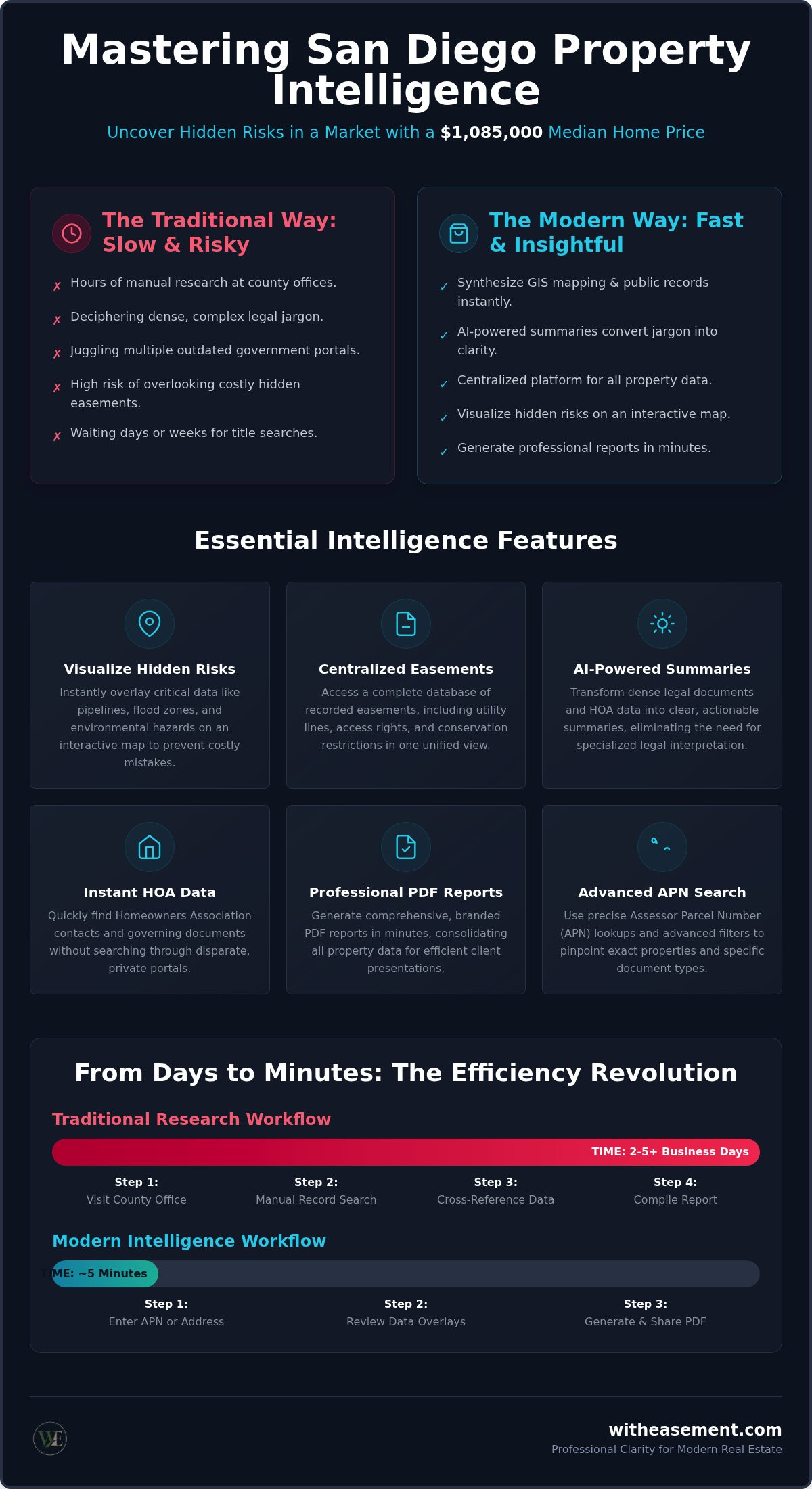
- Learn how modern property intelligence synthesizes GIS mapping and public records to eliminate hours of manual research.
- Use a San Diego property intelligence tool to visualize hidden risks like pipelines and flood zones on an interactive map.
- Convert dense legal jargon into clear, actionable insights using AI-powered summaries of recorded easements and HOA data.
- Generate professional, branded PDF reports that consolidate all property overlays and summaries for faster client presentations.
- Transition from fragmented searches to a centralized platform designed to maximize efficiency for high-volume real estate professionals.
Understanding the Power of a Property Intelligence Tool
Property intelligence is the strategic synthesis of spatial data and public records. It bridges the gap between raw information and actionable insights. By leveraging a Geographic Information System (GIS), these tools transform static maps into interactive intelligence hubs. A modern San Diego property intelligence tool consolidates disparate sources like assessor parcel maps, recorded encumbrances, and environmental hazard data into one interface. This eliminates the need to cross-reference multiple government websites or wait for physical records to arrive by mail.
The Evolution of Land Record Research
Historically, property research meant spending hours at a County Clerk's office or navigating clunky legacy databases. You had to pull individual deeds and manually trace chain of title. The rise of PropTech has simplified this journey significantly. Accessing raw data isn't enough for today's real estate professionals. You need a way to interpret that data quickly. In a market where the median home price sits at $1,085,000, speed is a competitive advantage. Professionals now rely on digital lookups to perform instant due diligence rather than waiting days for traditional title searches.
Key Components of Real Estate Intelligence
A comprehensive San Diego property intelligence tool integrates several critical data layers to provide a 360-degree view of any parcel. This centralized approach ensures that no detail is overlooked during the initial evaluation phase. It acts as a bridge between dense public records and the end-user, performing the role of a transparent facilitator.
- Centralized Recorded Easements: Instantly view utility lines, access rights, or conservation restrictions that impact land use.
- HOA Management Data: Access contact information and governing documents for Homeowners Associations without hunting through private portals.
- Environmental Risk Overlays: Visualize flood zones and pipeline proximity to assess long-term safety and insurance requirements.
This shift toward integrated data isn't just about convenience. It's about risk mitigation. Property intelligence allows you to see the "hidden" characteristics of a lot before you commit to a purchase or a development project. It empowers you to understand complex land use data without needing a law degree or a specialized consultant for every minor query. You can move from initial curiosity to deep, specific insight in seconds. This effortless efficiency is what separates modern investors from those still relying on manual, outdated processes.
Essential Features of a San Diego Property Intelligence Tool
Efficiency is the core of any high-performing real estate strategy. A San Diego property intelligence tool provides a unified dashboard to visualize data points that were previously trapped in separate silos. Instead of managing dozens of browser tabs, you can search by a specific street address or Assessor Parcel Number (APN) to unlock a comprehensive view of the land. This approach replaces the friction of traditional research with a streamlined, digital workflow.
Interactive Map Overlays and GIS Integration
Visualizing risk is far more effective than reading about it in a spreadsheet. Pipeline overlays are essential for preventing catastrophic building mistakes. If you're planning an accessory dwelling unit or a pool, knowing exactly where a high-pressure line sits saves significant time and capital. Flood risk zones are equally critical; they dictate mandatory insurance requirements and can drastically affect a property's long-term valuation. Tools that process datasets similar to those found in the American Housing Survey (AHS) allow you to see these risks in a geographic context. You can also view assessed values across a neighborhood to spot trends and anomalies instantly. This spatial awareness helps you make faster, more confident decisions without leaving your desk.
Advanced Search Filters and APN Lookups
Precision matters when you're dealing with high-stakes investments. Using an APN allows you to identify exact parcel boundaries and historical records without the ambiguity of street addresses. A powerful tool lets you filter by easement type, such as utility, sewer, or access rights. This means you don't have to sift through hundreds of irrelevant documents to find the one that matters. Map-based searching beats traditional list-based databases because it reveals how a property interacts with its surroundings. You can see how a neighbor's access easement might cut through your potential build site or identify shared driveway agreements at a glance.
Instant access to recorded easement documents removes the friction of secondary portal logins or manual requests. You can also query searchable HOA databases to find management contacts and document status. This level of integration ensures your due diligence is thorough and fast. If you're ready to modernize your research process, you can explore a comprehensive property easement search to see these features in action. This tool acts as a bridge between dense public records and the end-user, performing the role of a transparent facilitator for every transaction.
How AI Summaries Solve the Property Record Bottleneck
Traditional property records are often dozens of pages long and filled with archaic legal language. This creates a massive bottleneck in your workflow. You spend hours reading through documents just to find one sentence about a utility line. A modern San Diego property intelligence tool solves this by using AI to process dense PDF records into clear, bulleted summaries. You get the facts you need without the fluff. This automated synthesis allows you to understand the DNA of a property in seconds rather than days.
Translating Legalese into Actionable Insights
Identifying specific restrictions shouldn't take all afternoon. AI instantly flags 'Right of Way' and 'Utility' clauses that could block a potential development. It also scans complex HOA bylaws to highlight pet restrictions or rental caps that might derail an investment strategy. This automated process significantly reduces the risk of human error. You won't miss a critical detail buried on page 34 of a recorded deed. By converting dense legal text into digestible fragments, these tools ensure that high-level data is now within reach for every user. You gain the confidence to move forward without requiring a professional intermediary for every basic query.
The Speed Advantage in Competitive Markets
In a market where the median time on market is just 18 days, the first 24 hours of a listing are critical. If you wait for a title officer to explain a specific restriction, the property is likely already under contract. You need to close the information gap immediately. Using AI for real estate due diligence allows you to outpace competitors who are still stuck in manual review. It empowers you to provide instant answers to client questions about property limitations. This speed doesn't just save time; it wins deals.
Reliability is paramount when interpreting land use and zoning restrictions. AI-driven summaries act as a digital filter, presenting the most relevant data for your review. These systems are trained to recognize the patterns in recorded encumbrances and environmental risks. While they provide a massive head start, they also link back to the original source documents for final verification. This combination of speed and transparency makes AI an indispensable partner for anyone needing quick, reliable property intelligence. You spend your time making strategic decisions instead of digging through digital archives.
Building Professional Property Reports for Faster Due Diligence
Presenting a client with a stack of raw government documents is a recipe for confusion. A high-quality San Diego property intelligence tool transforms that data into a professional PDF report that's easy to digest. These reports serve as a tangible asset during client presentations, providing a clear overview of a property's potential and its limitations. By consolidating maps, summaries, and risk assessments, you position yourself as a tech-forward expert who values the client's time and security. It's about moving from raw data to a finished product that builds immediate authority.
What to Include in a Comprehensive Property Report
A truly useful report goes beyond basic address info. It should feature detailed parcel maps that visualize exact boundaries and how they interact with neighboring lots. You'll want to include the AI-driven easement summaries we discussed earlier to highlight utility or access restrictions. Don't forget to add environmental risk assessments, such as flood zone or pipeline proximity overlays. Finally, including HOA status and management contact information ensures your client knows exactly who to talk to about governing rules. This organized abundance makes the content easy to scan and act upon for buyers and investors alike.
Streamlining the Closing Process
The period between an accepted offer and a closed deal is often filled with friction. Much of this stress comes from the "unknowns" that surface during a title search. Providing pre-vetted data early in the process reduces the back-and-forth with title officers and lenders. Lenders appreciate seeing a clear assessment of environmental risks that might impact insurance requirements or loan eligibility. When you identify 'deal-breaker' information upfront, such as a major sewer easement that prevents a planned pool, you avoid costly escrow cancellations and wasted inspection fees.
Using a San Diego property easement search during the listing phase allows you to address these issues before they become crises. This proactive approach builds massive trust with potential homebuyers. They see that you've already done the heavy lifting of organizing information. It transforms the due diligence process from a hurdle into a streamlined path toward closing. You spend less time explaining problems and more time facilitating solutions. If you're ready to start providing this level of value to your clients, you can generate your first professional PDF property report today.
Maximizing Real Estate Efficiency with WithEasement
WithEasement provides a streamlined solution for professionals who require high-velocity data without the traditional friction of public record searches. It functions as an all-in-one platform, combining recorded easements, HOA data, interactive maps, and AI summaries into a single, cohesive interface. This eliminates the need to manage disparate logins or navigate outdated government portals. Using a San Diego property intelligence tool should feel like a competitive advantage, not a technical chore. Our membership model is designed specifically for high-volume realtors and investors who value their time and the accuracy of their due diligence.
A Centralized Hub for Realtor Due Diligence
Managing multiple subscriptions is inefficient and costly. WithEasement replaces fragmented tools with a cohesive ecosystem that handles the heavy lifting of data organization for you. You can switch between Address and APN searches instantly, ensuring you have the right context for every parcel, whether you are looking at a residential home or a new development site. Accessing San Diego interactive property maps allows for deep neighborhood analysis without the need for specialized GIS training. You get professional-grade insights in a digital-first market that demands immediate answers. It acts as a bridge between dense public records and the end-user, performing the role of a transparent facilitator for every transaction.
The platform also solves the "HOA gap" that many other tools ignore. By integrating searchable HOA databases alongside land use data, you can find management contacts and governing document status in the same workflow. This "no-nonsense" approach focuses on delivering value quickly without unnecessary barriers. You spend less time hunting for information and more time analyzing the impact of that data on your deals. It is the modern alternative to manual searches that today's market requires.
Getting Started with Professional Property Intelligence
Signing up for a membership gives you immediate access to national property data, allowing you to scale your research efforts beyond a single region. We provide the training and support needed to master our AI-powered reporting tools. This ensures you can generate professional PDF reports that build trust with your clients from day one. You are not just buying a utility; you are joining a community of tech-forward real estate experts who prioritize data-driven decisions. This sense of empowerment suggests that high-level data is now within reach for every professional without requiring specialized intermediaries.
Stop wasting hours on manual searches and legal translation. You can explore WithEasement Membership to unlock the full potential of a modern San Diego property intelligence tool. Transition from initial curiosity to deep, specific insight in seconds and start closing deals with total confidence. Our platform is ready to become your indispensable partner for quick, reliable property intelligence in 2026 and beyond.
Modernize Your Due Diligence Strategy
Real estate in 2026 demands more than just raw data; it requires the ability to interpret and present that data instantly. We've explored how a San Diego property intelligence tool bridges the gap between dense public records and actionable insights. By using AI to translate complex legalese and mapping tools to visualize environmental risks, you eliminate the guesswork that often stalls transactions. You now have the power to spot deal-breakers before they ever enter escrow.
Efficiency is your greatest asset in a competitive market. WithEasement gives you a centralized hub to access AI-Powered Summaries, Interactive Map Overlays, and Professional PDF Reports without the hassle of managing multiple subscriptions. This streamlined approach ensures you spend less time on manual research and more time closing deals. It's time to leave the friction of traditional manual searches behind and embrace a digital-first workflow that prioritizes your time. Unlock Professional Property Intelligence with WithEasement and start making faster, more confident property decisions today. Your clients will appreciate the professional clarity, and your business will benefit from the immediate results.
Frequently Asked Questions
How do I find a property's recorded easements online?
You can find recorded easements by using a specialized digital platform to search by street address or Assessor Parcel Number. This method eliminates the need for manual County Clerk visits or digging through fragmented government portals. The platform aggregates public records into a single interface for instant access. It's the most efficient way to identify utility lines or access rights that might impact your land use or development plans.
Can a property intelligence tool find HOA documents by address?
Yes, modern tools allow you to find HOA data simply by entering a property address. You'll gain access to management contact information and the status of governing documents without hunting through private portals. This feature is essential for identifying rental caps or pet restrictions early in the transaction. It acts as a transparent facilitator between dense public records and your specific research needs; ensuring you never miss a critical detail.
What is the difference between an APN search and an address search?
An address search uses the standard street location, while an APN search uses the unique Assessor Parcel Number assigned to the land. APN searches are often more precise for identifying exact parcel boundaries and historical records. This is because street addresses can sometimes be ambiguous or shared across multiple units. Using a San Diego property intelligence tool allows you to toggle between both methods to ensure your due diligence is thorough.
How accurate are AI-powered property summaries for legal records?
AI-powered summaries are designed to translate dense legalese into clear, actionable bullet points. They are highly reliable for flagging specific clauses like 'Right of Way' or 'Utility' restrictions that are easily missed during manual review. While these summaries provide a massive speed advantage, the platform always includes links to the original source documents for final verification. This combination of automated synthesis and transparency ensures your property intelligence is both fast and authoritative.
Does the platform show flood zones and gas pipeline overlays?
Yes, the platform includes interactive map overlays for both flood zones and high-pressure gas pipelines. Visualizing these environmental risks is critical for determining insurance requirements and ensuring building safety. You can see these layers alongside assessed values to understand how a property's location impacts its long-term viability. This spatial awareness helps you make confident decisions without needing a specialized consultant for every minor environmental query or risk assessment.
Can I generate a PDF property report for my clients?
You can generate a professional PDF property report that consolidates all your findings into a branded document. These reports include interactive map visuals, AI-powered summaries, and environmental risk assessments. They are perfect for client presentations or for sharing with lenders and title officers to streamline the closing process. It's a high-tech utility that builds immediate trust by presenting complex data in a welcoming and accessible format for every stakeholder.
Is a property intelligence tool useful for residential realtors?
Residential realtors find a San Diego property intelligence tool indispensable for speeding up their daily workflow. It allows you to answer client questions about easements or HOA rules in seconds rather than days. By identifying potential deal-breakers early, you avoid wasted inspection fees and prevent escrow cancellations. It's a modern alternative to traditional research that empowers you to outpace competitors in a fast-moving market where speed and professional clarity are everything.
How often is the property data and map overlay information updated?
Property data and map overlay information are updated on a regular cycle to maintain high levels of accuracy. This ensures that you are viewing the most current recorded easements, assessed values, and environmental hazard zones available for 2026. The platform acts as a reliable bridge to public records, performing the heavy lifting of data organization so you don't have to. You can trust that the insights you generate are based on the latest verified information.


