

San Diego properties with ADU potential sell for 35% more than comparable lots. This single statistic highlights why professional San Diego land parcel reports are now a competitive necessity for any serious real estate player. You've likely spent far too many hours navigating clunky government websites or decoding complex legal descriptions just to find a single easement. It's a frustrating, manual process that eats into your billable hours and stalls your development timelines. You need clarity, not more browser tabs.
You deserve a faster way to access property intelligence without the technical headache. This guide teaches you how to interpret comprehensive data to streamline your due diligence and identify hidden risks instantly. We'll show you how to generate professional PDF reports that simplify HOA details and visualize flood or pipeline hazards. You'll learn how to transform raw public records into clear, visual assets that build immediate trust with your clients and keep your projects moving forward.
Key Takeaways
- Understand why consolidated property intelligence is the foundation of modern real estate due diligence and risk mitigation.
- Access San Diego land parcel reports to instantly locate critical Assessor Parcel Numbers, legal descriptions, and recorded utility easements.
- Use interactive map overlays to identify infrastructure risks like pipelines and flood zones that aren't visible in standard text-based records.
- Generate professional PDF reports with AI-powered summaries to simplify complex property data for yourself and your clients.
- Streamline your research process by centralizing fragmented HOA data and property records into a single, high-tech platform.
What is a Land Parcel Report and Why Does it Matter?
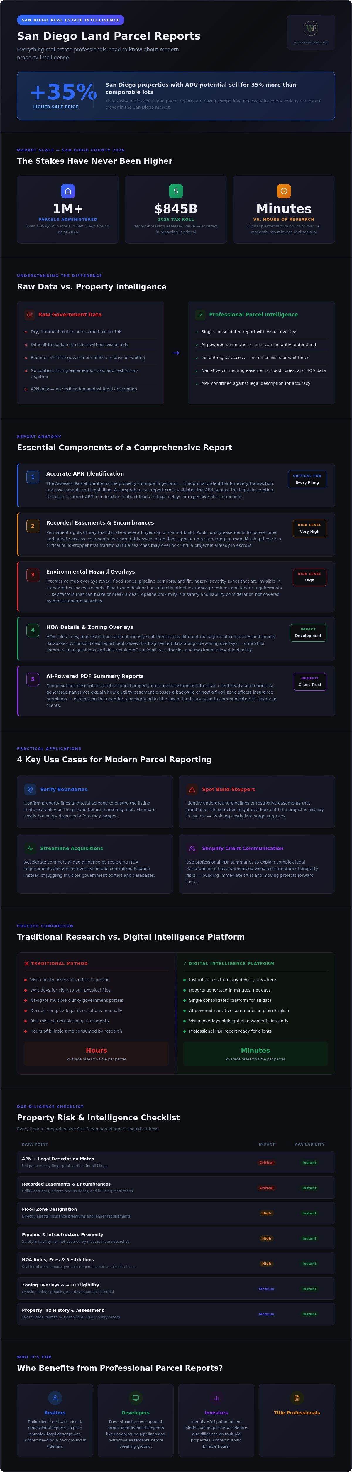
A land parcel report is a consolidated digital document that aggregates vital property data into a single, readable format. It moves beyond basic tax info to include recorded easements, HOA details, and environmental hazards. San Diego County currently administers over 1 million parcels; with the 2026 tax roll reaching a record $845 billion, the stakes for accuracy have never been higher. San Diego land parcel reports provide the necessary guardrails for this high-value market. These reports prevent costly development errors by identifying recorded restrictions that physically or legally limit how a property can be used.
The transition from physical county records to digital intelligence has changed the industry. You no longer need to visit government offices or wait days for a clerk to pull a file. Today, digital platforms act as a bridge. They perform the heavy lifting of organizing fragmented public records so realtors, developers, and savvy investors can focus on making decisions. This shift empowers you to act as a knowledgeable local specialist without requiring a background in title law or land surveying.
The Difference Between Raw Data and Property Intelligence
Raw data is just a list; intelligence is an actionable insight. A standard search for an Assessor's Parcel Number (APN) provides a starting point, but it doesn't tell the whole story. Government portals often present data in dry, fragmented lists that are difficult to explain to clients without visual aids. Professional San Diego land parcel reports take those fragments and build a narrative. They visualize how a utility easement crosses a backyard or how a flood zone affects insurance premiums. In professional environments, you need this level of clarity to build trust and move projects forward without second-guessing the source.
Key Use Cases for Modern Parcel Reporting
Modern reporting turns hours of research into minutes of discovery. Use these reports to gain instant clarity during the due diligence phase. They are particularly effective for the following tasks:
- Verify Boundaries: Confirm property lines and total acreage to ensure the listing matches the reality on the ground before you market a lot.
- Spot Build-Stoppers: Identify underground pipelines or restrictive easements that traditional title searches might overlook until the project is already in escrow.
- Streamline Acquisitions: Accelerate commercial due diligence by reviewing HOA requirements and zoning overlays in one centralized location.
- Simplify Client Communication: Use professional PDF summaries to explain complex legal descriptions to buyers who need visual confirmation of property risks.
It's about removing the friction from the research process. When you have high-level data at your fingertips, you don't just save time; you protect your reputation and your bottom line.
Essential Components of a Comprehensive San Diego Land Parcel Report
A professional report does more than verify ownership; it acts as a deep dive into the property's DNA. While many government portals offer fragmented data, professional San Diego land parcel reports integrate disparate threads like HOA management and tax history into a single, structured view. This level of clarity is essential for modern due diligence. With over 1,092,455 parcels administered in the county as of 2026, relying on manual searches is no longer a viable strategy for professionals who value their time.
The Importance of Accurate APN Identification
Your property's Assessor Parcel Number is its unique fingerprint. It's the primary identifier for every transaction, tax assessment, and legal filing. Using an incorrect number in a deed or contract can lead to significant legal delays or expensive title corrections. When you're navigating parcel numbers, precision is your best defense against administrative errors. A comprehensive report confirms the APN against the legal description to ensure you're researching the exact lot in question, whether it's a simple residential site or a complex commercial assembly.
Uncovering Recorded Easements and Encumbrances
Recorded easements are permanent rights of way that can dictate where a buyer can or cannot build. You'll often encounter public utility easements for power lines or private access easements for shared driveways. These encumbrances don't always appear on a standard plat map. By finding recorded easements early, you can advise clients on buildable area restrictions before they commit to a purchase. This proactive approach identifies "build-stoppers" that traditional title searches might miss during the initial discovery phase.
Beyond identification and access rights, a high-quality report must address the financial and community aspects of the land. This includes historical tax data and current HOA status. For example, staying updated on administrative changes is vital; a mandated $5.00 recording fee increase will take effect on January 4, 2027. A truly comprehensive report centralizes these details so you don't have to hunt through multiple portals. It provides management contact information for HOAs and breaks down assessed values over a multi-year period. If you want to simplify your workflow, consider how a WithEasement membership can consolidate these fragmented data points into a single, professional PDF.
Analyzing Environmental and Infrastructure Risks via Overlays
Text records provide the "what," but map overlays reveal the "where." High-quality San Diego land parcel reports bridge the gap between abstract data and physical reality. While a text-based report might mention a hazard, a visual overlay allows you to see exactly how a risk intersects with a proposed building site. This visual clarity builds immediate client trust. It transforms a complex risk assessment into a clear, undeniable picture that even non-experts can understand. You don't have to guess where a pipeline runs; you can see it. Visualizing these risks early ensures you don't waste time on properties with unfixable flaws.
Flood Zone and Topography Analysis
Understanding development feasibility starts with flood risk. In San Diego, flood zones dictate both the cost of mandatory insurance and the physical limitations of a site. If a parcel sits within a special flood hazard area, your buildability drops while your premiums climb. Use topography data to visualize land utility. Steep slopes or low-lying areas aren't just landscape features; they are financial variables. By layering this data over a parcel map, you can instantly see if a lot is actually a development nightmare. These overlays help you advise clients on the true cost of land that may require massive mitigation or expensive drainage systems. It's about seeing the hidden costs before they hit your balance sheet.
Pipeline and Utility Infrastructure Overlays
Safety is paramount when planning any excavation or construction. Identifying high-pressure gas lines and major water mains is a non-negotiable step in your due diligence. Building near major utility corridors carries significant safety implications and legal restrictions. Overlays help you avoid catastrophic "dig-ins" that cause utility damage and project shutdowns. These visual tools highlight infrastructure that standard public portals often hide behind complex menus. San Diego land parcel reports ensure these high-stakes details are front and center. You'll gain instant clarity on where it's safe to dig and where you must keep your distance. This level of detail is essential when navigating a county with over 1 million unique parcels. It protects your crew, your timeline, and your reputation as a professional who leaves nothing to chance.
How to Generate and Interpret Professional Parcel Reports
Generating San Diego land parcel reports shouldn't feel like a chore. Start by entering a specific property address or Assessor Parcel Number (APN) into your search tool. This simple action unlocks a wealth of archived data that previously required manual curation. Once you've identified the lot, select the specific layers you need to analyze. You can toggle between recorded easements, HOA management details, and critical infrastructure overlays. This modular approach ensures your final report contains only the most relevant intelligence for your specific project. You don't need to be a GIS expert to get these results; you just need the right interface.
The interpretation phase is where raw data becomes a professional asset. You aren't just looking at numbers; you're looking for patterns and risks. If you see a utility easement crossing a primary building site, you can immediately flag it for your client. This proactive interpretation prevents the "surprises" that often stall escrows or lead to expensive litigation. It's about turning a list of facts into a strategic roadmap for your development or purchase.
Leveraging AI for Property Record Summarization
Legal descriptions and recorded documents are notoriously dense. You don't have to spend hours decoding archaic terminology or searching for hidden clauses. By utilizing AI-powered property summaries, you can reduce hours of reading into minutes of actionable insight. These tools extract the core facts from recorded deeds and easement agreements while maintaining high levels of accuracy. This process simplifies complex terminology into digestible fragments, allowing you to identify "build-stoppers" without needing a legal degree. It's about working smarter to protect your investment.
Building Client Trust with Professional PDF Exports
A well-formatted property report carries significant psychological value. When you present a prospective homebuyer with a standardized, professional PDF, you immediately elevate your brand. Your report should include a clear breakdown of assessed values, visual risk overlays, and management contact info for any relevant HOAs. This transparency builds trust and reduces the friction of the decision-making process. Standardized reporting ensures that every client receives the same high-quality intelligence, reflecting your commitment to professional excellence. It shows you've done the work to verify every detail, including the latest administrative updates like the mandated recording fee increases coming in 2027.
To streamline your next project, you can access these professional parcel reports through a centralized membership platform. This tool handles the formatting for you, allowing you to download and share insights with a single click. You'll move from raw data to a polished client presentation in record time. It's the ultimate utility for any San Diego real estate professional looking to maintain an edge in a record-breaking market.
Streamlining Your Due Diligence with WithEasement
Efficiency is the ultimate competitive advantage in the local market. You've seen how fragmented public records can stall a transaction; WithEasement solves this by centralizing your entire research process into a single, intuitive platform. Instead of jumping between disparate government portals, you can access comprehensive San Diego land parcel reports with a few clicks. This tool acts as a bridge between dense data and actionable intelligence. It empowers you to identify risks that others might miss, ensuring your due diligence is both fast and flawless. You don't just get data; you get a professional partner that values your time.
The platform provides proprietary data layers that aren't found in standard public portals. This includes immediate access to HOA management contacts and detailed infrastructure overlays. By removing the technical barriers to property research, you can focus on closing deals rather than chasing down documents. Generate unlimited reports and maintain a high-tech edge in a crowded field. It's about having the right information exactly when you need it.
The Membership Advantage for Real Estate Professionals
A WithEasement Membership is designed to save you hours on every transaction. Property research often involves a frustrating cycle of manual searches and unanswered phone calls. This platform breaks that cycle. You can pull HOA management info instantly without making dozens of calls to administrative offices. Having this "no-nonsense" expert tool in your pocket allows you to answer client questions on the spot. It eliminates the need for specialized training or professional intermediaries. You'll gain the confidence to explain easements, risks, and property boundaries with total clarity. This effortless efficiency builds trust and positions you as a tech-forward innovator in the eyes of your clients.
Getting Started with Professional Property Intelligence
Accessing high-level property data has never been simpler. You can sign up for instant access to San Diego County records and start your first search in seconds. The process is straightforward; just enter a property address or an Assessor Parcel Number (APN) to begin. The platform handles the heavy lifting of organizing and summarizing the results for you. You can then toggle the specific data layers you need, from flood zones to utility pipelines, and generate a polished PDF report. Stop wasting time on clunky government websites and start using a tool built for modern real estate standards. Unlock professional property data today and transform the way you handle due diligence.
Elevate Your Property Intelligence Standards
Accessing comprehensive San Diego land parcel reports shouldn't be a hurdle in your workflow. You've learned how consolidated data reduces the friction of due diligence by bringing easements, HOAs, and infrastructure risks into a single view. Visualizing these hazards through interactive map overlays ensures you identify build-stoppers before they become expensive liabilities. This shift from raw data to actionable intelligence empowers you to act as a knowledgeable local specialist for every client.
By centralizing fragmented records and utilizing AI-powered summaries, you save hours on every transaction. You can now present professional PDF reports that simplify complex property risks and build immediate trust with prospective buyers. It's time to replace clunky government portals with a tech-forward utility that values your time and protects your reputation. You have the tools to turn dense public records into a strategic roadmap for success.
Generate your first professional land parcel report with WithEasement and experience the clarity of integrated property intelligence. You're now equipped to lead with confidence and precision in the San Diego market.
Frequently Asked Questions
What is included in a San Diego land parcel report?
A comprehensive report includes the Assessor Parcel Number (APN), legal descriptions, recorded easements, and current HOA management contacts. It also captures historical tax data and assessed values. Professionals use San Diego land parcel reports to consolidate these fragmented details into a single view. This prevents the need to search multiple government databases manually. You'll get a clear picture of the property's legal and financial status in minutes.
How do I find a property parcel map online?
You can access parcel maps through the San Diego County Assessor's portal or professional property intelligence platforms. While government sites offer basic maps, specialized tools provide interactive features that link maps directly to recorded documents. Simply enter the property address or APN to generate a visual representation of the lot boundaries. This digital access eliminates the need for physical office visits and speeds up your initial research phase.
Can I see easements on a standard land parcel report?
Standard tax reports usually don't display specific easement locations or rights. You typically need a dedicated easement search to identify utility paths or private access rights. Modern San Diego land parcel reports bridge this gap by integrating recorded easements directly into the document. This allows you to see underground pipelines or access restrictions that could limit development. It's a vital step for identifying build-stoppers before closing a deal.
Is HOA information included in San Diego County public records?
Public records often lack centralized HOA data, making it difficult to find management contact info or current fees. You usually have to hunt through recorded CC&Rs or make several phone calls to confirm these details. Professional platforms solve this by indexing HOA information alongside other property data. This ensures you have instant access to management contacts without the traditional administrative runaround that often stalls residential real estate transactions.
How do I look up a property by APN in San Diego?
You can look up any property by entering its unique APN into a specialized property search tool. The Assessor Parcel Number acts as a property fingerprint, ensuring you pull data for the exact lot in question. This is more precise than address-based searches, which can sometimes be ambiguous for multi-unit developments. Once you enter the number, the system pulls all relevant tax, ownership, and recorded document history associated with that specific parcel.
What are property map overlays and why are they useful?
Map overlays are visual data layers that sit on top of a standard parcel map to highlight specific risks. They are useful because they reveal invisible hazards like high-pressure gas lines or flood zones. By toggling these layers, you can see exactly where a risk intersects with a property boundary. This visual intelligence builds immediate trust with clients and helps you make informed decisions about building feasibility and insurance requirements.
How can AI help with property record research?
AI-powered property summaries process dense legal language from recorded deeds to extract core facts quickly. Instead of reading through dozens of pages of archaic terminology, you receive a concise summary of restrictions and rights. This technology reduces hours of manual research into minutes of insight. It helps you identify critical encumbrances or easements without needing a legal background. You'll maintain high accuracy while simplifying the due diligence process for your clients.
Are these land parcel reports suitable for commercial real estate due diligence?
These reports are highly effective for commercial due diligence because they centralize fragmented data for complex sites. Commercial transactions require deep dives into utility easements, pipeline locations, and zoning overlays. Having all this information in a professional PDF format allows for faster decision-making and clearer communication with stakeholders. It's a reliable way to verify property acreage and identify infrastructure risks that could impact the long-term value of a commercial investment.


