

The March 3, 2026, FEMA map update reclassified thousands of San Diego properties into high-risk zones for the first time in nearly two decades. If you manage real estate along the San Diego River corridor or in coastal communities like Mission Beach, your risk profile likely changed overnight. You already understand that flood risk impacts property value, but trying to assess property flood risk San Diego through slow government servers and complex codes is a major hurdle. It's exhausting to dig through layers of data just to find a simple answer about environmental hazards.
This guide provides the professional framework you need to identify flood zone designations with total precision. You'll master the ability to spot hidden risks that standard maps often overlook, ensuring your due diligence is bulletproof. We'll break down the latest FEMA reclassifications, explain the current insurance discount windows, and show you how to generate professional-grade reports that provide clarity for any real estate investment. It's time to replace guesswork with high-level data and move forward with confidence.
Key Takeaways
- Understand the critical difference between 100-year and 500-year floodplains to accurately gauge long-term probability rather than historical frequency.
- Learn the professional workflow to assess property flood risk San Diego by using Assessor’s Parcel Numbers for pinpoint accuracy.
- Discover why flood data should never be viewed in isolation and how multi-layered map overlays provide a comprehensive view of environmental hazards.
- Identify the specific FEMA codes and Base Flood Elevation metrics that dictate mandatory insurance requirements and development permits.
- Replace slow, manual government database searches with integrated intelligence platforms that generate professional PDF reports in seconds.
Understanding Property Flood Zones and FEMA Designations
Flood risk isn't just about past weather events. It's a precise calculation of historical frequency and topographical vulnerability. The Federal Emergency Management Agency (FEMA) manages this data through national risk mapping. These maps, known as Flood Insurance Rate Maps (FIRMs), act as the regulatory baseline for real estate transactions. When you assess property flood risk San Diego, you must remember that a 'low risk' designation doesn't mean 'no risk'. Modern environmental assessments show that flood patterns are shifting, making static maps just one part of the puzzle.
Decoding Common FEMA Flood Zone Codes
Understanding the alphabet soup of FEMA codes is essential for any property analysis. These designations determine everything from your insurance premiums to your building permits. The most common codes include:
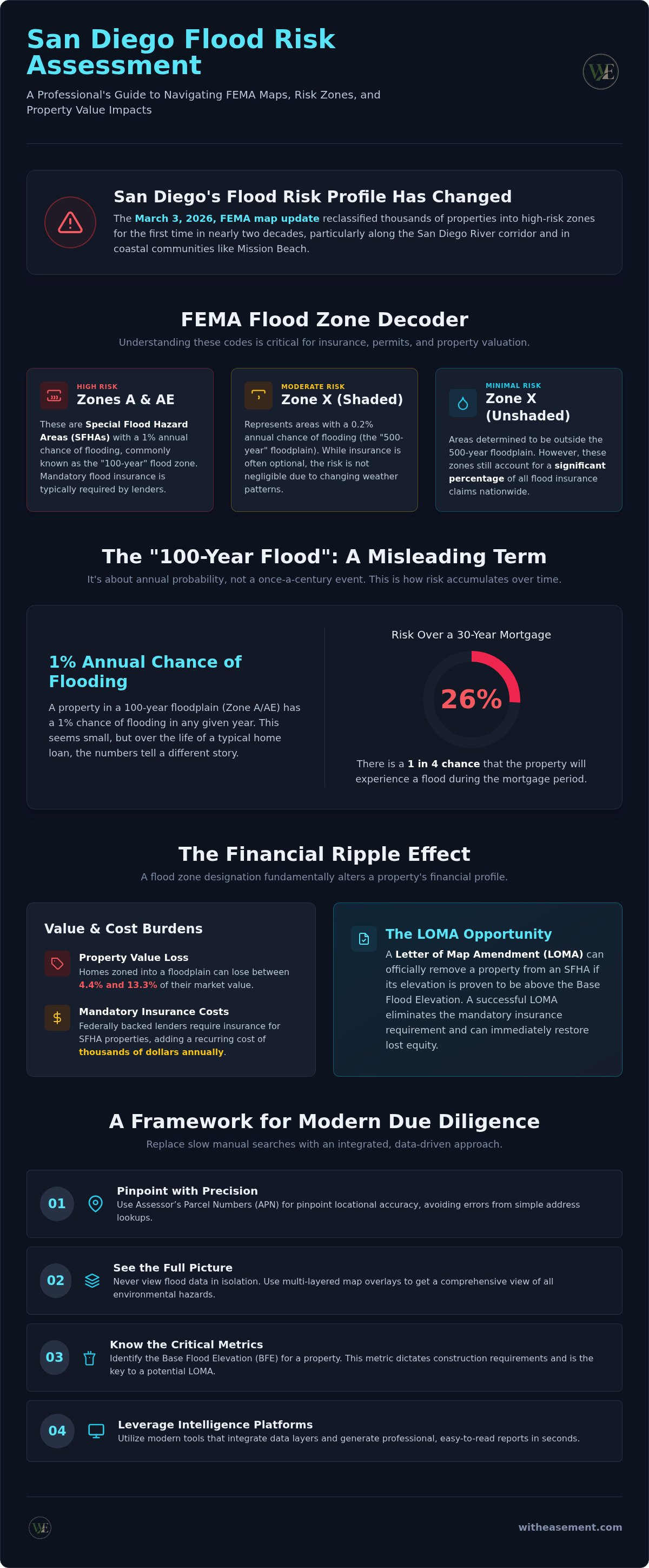
- Zone A and AE: These are Special Flood Hazard Areas (SFHAs). They have a high probability of flooding, often referred to as a 100-year flood zone.
- Zone X (Shaded): This indicates a moderate risk area, typically between the limits of the 100-year and 500-year floods.
- Zone X (Unshaded): These are areas of minimal flood risk. It's a mistake to ignore these zones, as they still account for a significant percentage of flood insurance claims.
The Base Flood Elevation (BFE) is another critical metric. It represents the height water is expected to reach during a base flood. For properties in Zone AE, the BFE is a hard line that dictates construction requirements. If the lowest floor of a building is below this elevation, insurance costs will likely spike. It's a simple cause and effect: lower elevation equals higher financial risk.
The Impact of Flood Designations on Property Value
A flood zone designation does more than just require a policy. It fundamentally alters the financial profile of a property. If a parcel falls within an SFHA, federally backed lenders require mandatory flood insurance. This adds a recurring carrying cost that can reach thousands of dollars annually, directly impacting a buyer's purchasing power.
There is also a marketability stigma attached to high-risk zones. Recent data suggests that homes zoned into a floodplain can lose between 4.4% and 13.3% of their value. However, these designations aren't always permanent. If you believe a property was incorrectly mapped due to its actual elevation, you can apply for a Letter of Map Amendment (LOMA). A successful LOMA removes the mandatory insurance requirement and can immediately restore lost equity. Identifying these opportunities is a hallmark of professional due diligence.
Evaluating 100-Year vs. 500-Year Flood Risk Profiles
The term "100-year flood" is one of the most misunderstood labels in real estate. It doesn't mean a flood happens once every century. Instead, it describes a 1% annual probability of such an event occurring. Over the life of a standard 30-year mortgage, a property in this zone has a 26% chance of flooding. To effectively assess property flood risk San Diego, you must shift your perspective from historical timing to mathematical probability. While lenders focus on the 100-year line for compliance, insurers and savvy investors look at the 500-year data to understand the true environmental exposure.
Why the 1% Annual Chance Matters to Lenders
Lenders view the 100-year line as a primary risk threshold. If a structure sits within this boundary, federally backed mortgages trigger a mandatory flood insurance purchase requirement. This rule stems from federal Floodplain Management standards designed to protect the secondary mortgage market. The National Flood Insurance Program (NFIP) typically provides this coverage. Failing to identify this status early can derail a real estate closing. Lenders won't fund the loan until they see proof of a policy. This adds a critical step to your timeline, making early detection a priority for any professional transaction.
The Growing Significance of the 0.2% Annual Chance Zone
The 500-year floodplain is the area with a 0.2% annual risk of flooding. While it sounds negligible, these zones are no longer considered safe harbors by modern standards. Changing weather patterns and increased urban development often overwhelm local drainage systems. This leads to localized flooding in areas that FEMA technically labels as moderate to low risk. Many property owners in these zones opt for voluntary insurance because they recognize that water doesn't respect a line on a government map.
In fact, a significant portion of flood claims originate outside of the high-risk 1% zones. You can visualize these risks instantly by using integrated flood zone overlays to see how a parcel sits relative to both the 100-year and 500-year lines. Understanding this distinction allows you to advise clients on long-term safety rather than just meeting minimum lender requirements. It's an essential layer of data when you assess property flood risk San Diego for high-value investments.
Critical Data Layers for Environmental Due Diligence
Viewing flood risk in isolation is a common mistake that can lead to expensive oversights. Professional due diligence requires a multi-layered approach that integrates environmental data with actual land-use records. When you assess property flood risk San Diego, a standard FEMA map only tells part of the story. You must see how water interacts with the legal encumbrances and physical infrastructure of the parcel. Using map overlays is the professional standard for identifying these intersections before they become liabilities.
Integrating Flood Maps with Property Easements
A San Diego property easement search reveals critical drainage rights that impact how a property handles excess water. If a parcel sits in a flood zone, an existing drainage easement might restrict your ability to grade the land or build additional structures. Building near utility easements in potential flood zones creates a double risk. You face potential physical damage to the structure and restricted access for utility repairs during an emergency event.
Visualizing these layers together is the only way to spot conflicts early. By using a San Diego interactive property map, you can toggle between flood zones and recorded easements instantly. This level of clarity ensures that your site plan doesn't clash with the legal reality of the land. It's a simple step that separates a basic search from a professional risk assessment.
The Role of Pipeline and Infrastructure Overlays
Infrastructure overlays add another essential dimension to your environmental review. Gas and water pipeline locations are vital pieces of information during a flood event. High-pressure lines can become significant hazards if soil erosion or shifting occurs during heavy rains. Identifying these infrastructure encumbrances before purchase prevents costly surprises during the development or renovation phase.
Traditional research usually requires jumping between multiple government databases and department websites. This manual process is slow and prone to error. Centralized platforms solve this by allowing you to toggle pipeline layers alongside flood data. This integrated view helps you understand the property's health as a whole. It also clarifies HOA boundaries, which often dictate who is responsible for maintaining flood-control infrastructure like bioswales or retention basins. Accessing this data in one place saves time and provides the professional-grade reports your clients expect.
A Framework for Conducting In-Depth Property Risk Assessments
Professional due diligence isn't about looking at one map. It's about following a methodical process to uncover every potential hazard. To assess property flood risk San Diego with total accuracy, you need to move beyond simple address searches and adopt a parcel-centric approach. This framework ensures you don't miss hidden encumbrances that could impact a property's value or development potential.
- Step 1: Locate the parcel using the Assessor’s Parcel Number (APN) for maximum precision.
- Step 2: Identify the primary FEMA flood zone designation and the Base Flood Elevation (BFE).
- Step 3: Overlay easement and infrastructure data to check for drainage or access conflicts.
- Step 4: Generate a summary report to document findings for disclosure and due diligence.
Following these steps allows you to build a comprehensive risk profile. You can start this process now by signing up for a WithEasement Membership to access integrated parcel data and professional reporting tools instantly.
Using APN for Precise Parcel Identification
Address-based searches sometimes lead to inaccurate map placement because they rely on geocoding, which can be imprecise. This is a significant issue for large lots or properties near municipal borders. Environmental screening requires parcel-level data to be truly effective. APN-based searches ensure you are assessing the exact legal boundaries of the risk. By pinning data directly to the legal lot lines, you eliminate the margin of error that comes with standard search engines. It's the only way to assess property flood risk San Diego with professional-grade certainty.
Interpreting Results for Client Disclosures
Realtors have a professional responsibility to communicate flood risk clearly to prospective buyers. You don't need to be a hydrologist, but you do need to translate technical jargon into actionable advice. It's not enough to just hand over a map; you must explain what the designations mean for the buyer's future. AI-powered summaries are incredibly helpful here. They can translate complex codes like "Zone AE" or "BFE" into clear sentences that explain insurance requirements and building restrictions.
Packaging this information effectively is just as important as finding it. Including professional PDF reports in your disclosure package builds trust and demonstrates that you've done the heavy lifting. These reports provide a clear, visual record of the due diligence process. They protect you by documenting the information provided and protect the buyer by ensuring they have all the facts before they close. Clarity is the ultimate tool for reducing friction in a real estate transaction.
Leveraging Integrated Intelligence Platforms for Risk Analysis
Manually searching through fragmented government databases is a relic of the past. To effectively assess property flood risk San Diego, you shouldn't have to navigate three different map servers and a dozen PDF links just to verify a single parcel. This disjointed process isn't just slow; it's a liability. Every minute spent fighting a clunky interface is a minute lost on closing a deal or advising a client. WithEasement acts as the professional bridge between dense public records and the clarity you need to move forward. It replaces manual hunting with a centralized, tech-forward platform designed for speed.
The future of property research belongs to those who value their time. High-volume realtors and investors are moving away from traditional administrative methods in favor of instant reporting. Adopting a membership-based model for your due diligence isn't just an expense; it's a strategic investment in professional clarity. It ensures that you have high-level data at your fingertips without requiring specialized training or professional intermediaries.
The Power of AI-Powered Property Summaries
The shift toward AI for real estate due diligence is changing how professionals handle environmental screening. Instead of reading technical flood codes yourself, AI-powered summaries distill complex data into clear, actionable insights. These tools analyze recorded easements and flood designations instantly. You get the effortless efficiency of a clear answer in seconds rather than hours. This accuracy comes from a centralized data model that doesn't miss the fine print hidden in dense public records. It's about unlocking the story of the land with minimal friction.
Generating Professional PDF Property Reports
Generating professional PDF property reports is the final step in a high-level due diligence workflow. These reports consolidate HOA data, flood zones, and easement overlays into a single document. It's a superior way to build trust with clients who demand transparency. When you provide a comprehensive report, you demonstrate a level of thoroughness that standard disclosures can't match.
A professional report acts as a permanent record of your due diligence. It protects your reputation and provides your clients with the confidence they need to sign. Professionals can explore membership options to unlock full access to these reporting tools. Investing in an integrated platform ensures that your research is always fast, reliable, and professional-grade. It's time to stop searching and start visualizing the full risk profile of every property you assess.
Master Your Property Risk Strategy
Protecting your real estate investments requires a move from basic compliance to comprehensive intelligence. You now have the framework to identify FEMA designations, understand probability versus frequency, and layer environmental data with legal encumbrances. When you assess property flood risk San Diego, you aren't just checking a box; you're ensuring the long-term viability of a parcel. Precise data is the only shield against the financial impact of shifting environmental zones and mandatory insurance requirements.
Stop wasting hours on slow government servers and fragmented records. Streamline your property due diligence with a WithEasement Membership. You'll gain instant access to AI-powered property summaries, integrated flood and pipeline map overlays, and professional PDF reporting tools. These features empower you to deliver expert-level insights to your clients with effortless efficiency. Take control of your research process and approach every deal with the authority of a local specialist. Your next successful transaction starts with the right data.
Frequently Asked Questions
How do I determine if a property is in a high-risk flood zone?
You can determine a property's risk level by reviewing the official FEMA Flood Insurance Rate Maps (FIRMs). To accurately assess property flood risk San Diego, professionals use interactive map overlays that combine FEMA data with parcel-specific details. These tools allow you to visualize high-risk boundaries relative to the exact lot lines. Identifying these zones early prevents unexpected insurance costs and ensures that you meet all lender requirements during the due diligence phase.
What is the difference between a 100-year and 500-year floodplain?
The primary difference lies in the annual mathematical probability of a flood event. A 100-year floodplain has a 1% annual chance of flooding, which equates to a 26% risk over a 30-year mortgage. In contrast, a 500-year floodplain has a 0.2% annual risk. While the 500-year zone is technically lower risk, many modern environmental assessments consider it an essential metric for understanding long-term safety and identifying potential drainage issues outside of the primary hazard zones.
Are FEMA flood maps updated regularly to reflect current risks?
FEMA updates flood maps periodically to incorporate new topographical data and changing weather patterns. For example, major updates became effective on March 3, 2026, reclassifying thousands of properties into high-risk zones for the first time in years. It's vital to check for the most current data because older maps may not reflect recent infrastructure changes. Relying on outdated information can lead to inaccurate risk profiles and missed insurance discount windows during a property transaction.
Does a flood zone designation affect my ability to get a mortgage?
A flood zone designation doesn't prevent you from getting a mortgage, but it does trigger specific requirements. If a property sits in a Special Flood Hazard Area (SFHA), federally backed lenders require you to purchase flood insurance before closing. This adds a recurring cost to your monthly payment, which can impact your debt-to-income ratio. Identifying these requirements early allows you to factor the insurance premiums into your total investment cost and avoid delays during the final approval process.
Can I build on a property that is located in a Special Flood Hazard Area?
Building in a Special Flood Hazard Area is possible, but it requires strict adherence to local development regulations. You must typically elevate the lowest floor of the structure to or above the Base Flood Elevation (BFE). Permits for grading or new construction in these zones often require an engineering analysis to prove the project won't increase flood risks for neighboring properties. Following these standards protects your investment and helps you secure more affordable insurance rates through the national program.
How do I find hidden easements that might affect property drainage?
Finding hidden easements requires a search of recorded land documents tied to the property's legal description. These records reveal drainage rights or utility access points that standard flood maps don't show. To assess property flood risk San Diego effectively, you should use an integrated platform that overlays easement data with flood zones. This combined view helps you spot potential conflicts where water flow might be restricted by existing infrastructure or legal encumbrances.
What is a Base Flood Elevation and why does it matter for my house?
Base Flood Elevation (BFE) is the anticipated height that floodwaters will reach during a 1% annual chance flood event. This measurement is the benchmark for both construction and insurance pricing. If your home's lowest floor is below the BFE, your flood insurance premiums will be significantly higher. Knowing this number allows you to plan renovations or new builds that mitigate risk and ensure the structure remains resilient against seasonal environmental hazards that might impact your property's value.
Is flood insurance required if my property is in Zone X?
Flood insurance is generally not mandatory if your property is located in Zone X, which is considered a moderate-to-low risk area. However, lenders may still recommend it, and many owners choose to purchase voluntary policies. Data shows that a significant percentage of flood claims occur outside of high-risk zones. Purchasing a policy in Zone X is often much more affordable than in high-risk areas, providing a cost-effective way to protect your real estate equity from unpredictable weather.


