

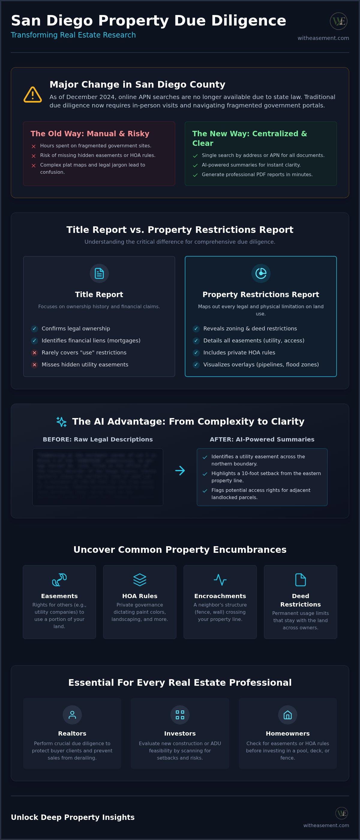
Did you know that as of December 2024, online APN searches are no longer available in San Diego County due to state law? This change means that traditional due diligence often requires an in-person visit or hours spent navigating fragmented government portals. It's a significant roadblock when you need a fast, reliable San Diego property restrictions report to move a deal forward. You likely feel the pressure of missing a hidden easement or struggling to decode complex plat maps. These hurdles can easily block a development project or lead to costly legal delays.
We believe your time is better spent closing deals than playing detective with public records. This guide shows you how to access, interpret, and utilize comprehensive property restriction data to streamline your real estate due diligence. You'll learn how to transform dense legal jargon into a professional PDF report that provides instant clarity on zoning, pipeline overlays, and HOA obligations. We're shifting from manual data collection to a centralized, AI-enhanced intelligence platform that reduces your risk of post-purchase issues. Let's look at how you can unlock deep property insights with just a few clicks.
Key Takeaways
- Identify hidden encumbrances like private HOA rules and easements that don't always appear in a standard title search.
- Use AI-powered summaries to translate complex legal descriptions into clear, actionable bullet points instantly.
- Simplify your research by using a single address or APN to retrieve all recorded documents without navigating fragmented government sites.
- Generate a professional San Diego property restrictions report in PDF format to provide clients with immediate clarity and reduce legal risk.
- Visualize physical limitations through interactive maps featuring pipeline overlays and flood zone data for more accurate due diligence.
What is a Property Restrictions Report?
A San Diego property restrictions report is a professional document that maps out every legal and physical limitation tied to a specific parcel of land. Think of it as a comprehensive blueprint for what is actually possible on a site. While most people look at property through the lens of price or location, seasoned professionals focus on restrictions. This report consolidates fragmented data from county assessors, recorders, and local planning departments into one centralized view. It helps you understand What is an Encumbrance? by highlighting specific claims, easements, or liabilities that affect your rights. These details are essential for determining the "highest and best use" of a property before you finalize a purchase or break ground on a project.
The Difference Between Title Reports and Restriction Reports
Many people mistake a title search for a full land use analysis. Title reports mainly focus on ownership history and financial liens; they confirm who owns the land and which banks hold a stake in it. In contrast, a San Diego property restrictions report highlights how you can actually use the soil. Title insurance protects you against ownership disputes, but it rarely covers "use" issues like hidden utility easements that might block a planned addition. Relying solely on title insurance can lead to devastating development surprises. You might discover a pipeline overlay or a specific zoning restriction that makes your intended project impossible only after you've already committed capital.
Who Needs a Professional Property Analysis?
Accessing clear, consolidated property data isn't just for large-scale developers. Different stakeholders use these insights to protect their interests and save time:
- Realtors: They perform essential due diligence for buyer clients to ensure there are no hidden encumbrances that could derail a sale.
- Investors: They evaluate the feasibility of new construction or ADU projects by scanning for setbacks and environmental risks.
- Homeowners: They check for recorded utility easements or HOA rules before investing in a pool, deck, or new fencing.
By using a professional analysis, you remove the guesswork from the research process. You get instant clarity on complex plat maps and legal descriptions that are usually buried in outdated government websites. This proactive approach builds trust with clients and significantly reduces the risk of post-purchase legal issues or construction delays. It's about moving from curiosity to deep, specific insight without the friction of traditional administrative research.
Common Encumbrances: Easements, Liens, and HOAs
Encumbrances are legal claims or limitations on a property that don't necessarily prevent a transfer of ownership but do restrict how the land is used. A comprehensive San Diego property restrictions report identifies these hurdles before they become legal liabilities. While public records show where a parcel sits, they don't always reveal who else has a right to be there. This lack of transparency can lead to expensive project delays or unexpected maintenance costs if you aren't prepared for the recorded obligations tied to the land.
Common encumbrances include:
- Easements: Legal rights that allow others to use specific portions of your land for utilities, drainage, or access.
- HOA Restrictions: Private rules that dictate everything from paint colors and landscaping to parking and maintenance standards.
- Encroachments: Physical structures, like a neighbor's fence, retaining wall, or shed, that cross over your property line.
- Deed Restrictions: Historical, environmental, or usage limits that stay with the land regardless of who owns it.
Identifying Different Types of Easements
Easements are the most common surprises in real estate due diligence. Utility easements are standard; they allow water, sewer, and power companies to maintain infrastructure on your parcel. However, access easements can be more complex. These grant right-of-way to neighbors with landlocked parcels, potentially putting a driveway through what you thought was a private backyard. Performing a property easement search is the only way to visualize hidden underground infrastructure or recorded paths that don't appear on a basic map. It's about seeing the invisible lines that dictate your building envelope and ensuring your project stays within legal bounds.
The Impact of HOA Data on Property Value
Private governance can be just as restrictive as city code. Homeowners Association (HOA) data includes Covenants, Conditions, and Restrictions (CC&Rs) that govern daily life and property aesthetics. It's vital to check for short-term occupancy restrictions if you plan to use the property as a rental. Some associations have strict caps on the number of units that can be leased at once or forbid certain types of exterior modifications. You can find recorded HOA documents by searching the address or parcel number, ensuring you aren't surprised by unexpected fees or usage limits. If you want to simplify this process and avoid missing hidden details, you can access centralized property intelligence to see all these layers in one place.
The Role of AI in Interpreting Complex Property Records
Manual research is often a race against the clock. You're diving into decades of scanned public records, hoping you don't miss a single sentence that could stall a project. A professional San Diego property restrictions report now leverages AI to do the heavy lifting. This technology acts as a bridge between dense public data and the end-user. It doesn't just collect information; it interprets it. By moving away from manual review, you significantly reduce the risk of human error that often leads to post-purchase legal issues.
AI can scan hundreds of pages of recorded documents in seconds. While a human researcher might take hours to find a specific utility easement buried in a 1970s deed, AI identifies it instantly. It automatically flags high-risk items like flood zones or pipeline overlays. This speed is a massive advantage in a competitive market. For instance, AI-driven appraisal tools in nearby Riverside County have already made property processes over 40% faster. This level of efficiency ensures your due diligence is both thorough and rapid.
How AI Summaries Streamline Due Diligence
Dense legal jargon shouldn't be a barrier to understanding land use. Using AI for real estate due diligence allows you to translate complex legalese into actionable bullet points. It instantly identifies key clauses in lengthy easement agreements and summarizes zoning codes to determine your actual buildable area. Instead of guessing what a "prescriptive easement" means for your specific parcel, you get a clear explanation. This clarity empowers you to make confident decisions without needing a specialized legal background.
Visualizing Data with Interactive Overlays
Data is most valuable when you can see it. Interactive maps allow you to visualize flood risks and environmental hazards directly over parcel boundaries. You can identify gas and water pipeline locations for safe excavation before a shovel even hits the ground. This spatial intelligence is a core feature of a modern San Diego property restrictions report. It even allows you to compare assessed values across entire blocks to spot market trends. You're no longer looking at a static document; you're interacting with a living map of property intelligence.
Steps for Conducting Professional Property Due Diligence
Professional due diligence requires a methodical approach to ensure no detail is overlooked. You need a workflow that transitions from broad geographic data to specific legal restrictions. Following a structured process allows you to build a comprehensive San Diego property restrictions report that serves as a single source of truth for your project. This systematic review reduces the friction of manual research and ensures your findings are both accurate and actionable.
Follow these five essential steps for a complete analysis:
- Step 1: Locate the parcel. Use the property address or Assessor Parcel Number (APN) to identify the exact boundaries.
- Step 2: Retrieve recorded documents. Collect all recorded easements, liens, and encumbrances tied to the land.
- Step 3: Analyze zoning. Review local land use designations to confirm if your intended project is legally permissible.
- Step 4: Verify HOA status. Check for private CC&Rs and association rules that might impose stricter limits than city code.
- Step 5: Consolidate findings. Group all data points into a professional report for buyers, lenders, or development teams.
Navigating Public Records vs. Private Platforms
Traditional research often feels like a fragmented puzzle. Effective December 9, 2024, online Assessor Parcel Number (APN) searches are no longer available in San Diego County due to Assembly Bill 1785. This change means you must often visit the county recorder's office in person for basic parcel identification. Centralized digital databases solve this problem by aggregating public data into a searchable format. These platforms allow you to verify the accuracy of property data in seconds. You get the benefit of professional clarity without the administrative burden of traveling to government kiosks.
Red Flags to Look for in a Property Report
A thorough San Diego property restrictions report helps you spot issues that could derail a deal. Watch out for prescriptive easements, which can be established in California after five years of open and continuous use by another party. These don't always appear on standard title searches. Other red flags include conflicting zoning designations where the city and county records don't align. You should also look for oversized utility easements. A large sewer or power line easement can significantly reduce your buildable area, rendering a seemingly perfect lot unusable for construction.
Ready to simplify your research process? Start your property search now to access professional reports and interactive data layers instantly.
Accessing Centralized Property Intelligence Platforms
Modern property research demands more than just access to raw data. You need a way to synthesize information into a format that wins client trust and closes deals. A centralized property intelligence platform transforms the way you handle a San Diego property restrictions report. Instead of managing a stack of disconnected documents and browser tabs, you work within a single, unified environment. This shift toward tech-forward research tools future-proofs your business by ensuring you always have the most current data at your fingertips.
Centralized platforms provide several key advantages for professionals:
- Data Consolidation: View zoning, easements, and hazard data in one place.
- Professional Output: Generate branded PDF reports for clients and stakeholders.
- Real-Time Updates: Access the latest recorded documents without visiting county kiosks.
- Search Efficiency: Locate properties by address or APN in seconds.
The Power of Interactive Mapping
Visualizing site constraints is the fastest way to understand a parcel's potential. An interactive property map allows you to layer flood zones, gas pipelines, and recorded easements on a single screen. You see the exact boundaries and assessed values without toggling between different government portals. This spatial clarity helps you identify buildable areas and environmental hazards immediately. It's about moving from reading about a property to seeing its physical and legal limitations in real time.
Why a Membership is Better Than One-Off Reports
For high-volume real estate professionals, one-off searches are often inefficient and costly. A membership model provides continuous access to updated parcel data and new recordings as they happen. This ensures your due diligence is always based on the latest available information. You streamline your entire workflow from the initial lead to the final close of escrow. Having unlimited searches allows you to vet dozens of properties quickly, focusing your energy only on the most viable opportunities.
The final step in professional research is communication. You need to present your findings in a way that builds authority. Generating a professional PDF report allows you to share comprehensive data with buyers, lenders, or partners. These reports distill complex technical insights into a branded, easy-to-read format. They provide the clarity needed to reduce post-purchase friction and protect all parties involved in the transaction. By utilizing these professional tools, you position yourself as a knowledgeable specialist who values accuracy and efficiency.
Streamline Your Property Due Diligence Today
Professional land use research doesn't have to be a manual, time-consuming process. By shifting to a centralized intelligence platform, you move beyond the limitations of fragmented public records. You've learned how to identify hidden encumbrances, interpret complex legal jargon with AI, and visualize site constraints through interactive mapping. These tools ensure that your next San Diego property restrictions report is accurate, comprehensive, and ready for your stakeholders in seconds.
Empower your business with high-level data that was once buried in government kiosks. You can now search by address or APN to uncover recorded easements, HOA data, and flood zones instantly. This modern approach reduces your risk and builds immediate trust with buyers. Access professional property reports and AI summaries with WithEasement to simplify your workflow and focus on what matters most. You're now equipped with the tools to handle even the most complex property records with effortless efficiency and clarity. Start exploring today and move forward with total confidence.
Frequently Asked Questions
How do I find a property restrictions report for a specific address?
You can find a professional San Diego property restrictions report by using a centralized data platform like WithEasement. Simply enter the property address to access a consolidated view of recorded easements, zoning codes, and HOA data. This method is much faster than searching through fragmented government databases. It provides a single document that interprets complex records into clear, actionable insights to streamline your property due diligence process.
Can I look up property easements by APN online?
While state law AB 1785 restricted online APN searches on many public portals as of December 2024, you can still access this data through professional intelligence platforms. These tools allow you to search by parcel number to retrieve recorded documents and easements instantly. This bypasses the need for in-person visits to the county office. It ensures you have the necessary documentation to evaluate land use rights without administrative delays.
What is included in a professional land use summary?
A professional land use summary includes a breakdown of all legal and physical constraints on a parcel. You'll find details on recorded easements, building setbacks, zoning designations, and potential environmental hazards like flood zones. These summaries often use AI to translate dense legal descriptions into bullet points. This helps you quickly determine the highest and best use for the land while identifying risks that standard title searches might miss.
How do I check if a property is in a flood zone?
You can check a property’s flood risk by using interactive mapping tools that feature flood zone overlays. These maps display FEMA data directly over parcel boundaries, allowing you to see exactly how much of the land is affected. This is a critical step for insurance planning and construction feasibility. Accessing this data through a centralized platform ensures you are viewing the most current environmental risk layers alongside other property restrictions.
Are HOA documents included in public property records?
HOA documents like Covenants, Conditions, and Restrictions (CC&Rs) are typically recorded with the county, but they can be difficult to locate in public databases. A professional San Diego property restrictions report includes these private rules to ensure you understand aesthetic and usage limits. These documents dictate everything from rental caps to architectural standards. Finding them through a specialized search saves time and prevents surprises from private governing bodies after a purchase is finalized.
What is the difference between a parcel map and a plat map?
A parcel map primarily identifies the boundaries and Assessor Parcel Number (APN) for tax purposes. A plat map is a more detailed survey that shows how a larger piece of land is divided into individual lots. It often includes specific legal descriptions, recorded easements, and dedicated public rights-of-way. Understanding both is essential for accurate due diligence, as the plat map provides the technical details needed for construction and development planning.
How can AI help me understand my property’s zoning?
AI helps you understand zoning by scanning hundreds of pages of municipal code to find the specific rules that apply to your parcel. It can instantly summarize density limits, height restrictions, and required setbacks. This technology removes the need to manually interpret complex planning documents. By using AI-powered summaries, you get a clear picture of what you can legally build on a property without spending hours on manual government research.
Where can I find pipeline overlays for my land?
You can find gas and water pipeline overlays by using specialized property intelligence platforms that feature interactive map layers. These overlays show the location of underground infrastructure that could impact excavation or building footprints. Identifying these pipelines early is vital for safety and project feasibility. Having this data visible on your parcel map allows you to plan around utility lines and avoid costly damage or legal disputes during development.


