

A clean title report doesn't always guarantee a clear building site. You might think a parcel is ready for development, but a high-pressure gas main buried just beneath the surface can halt a project before the first shovel hits the dirt. Accessing a reliable San Diego pipeline overlay map is the only way to visualize these hidden utility risks relative to property lines. Without this intelligence, you're essentially flying blind during the due diligence phase.
It's frustrating to waste hours clicking through fragmented government websites or struggling with technical GIS data that requires a specialist to decode. You need answers quickly to protect your clients and your professional reputation. This guide shows you how to unlock professional property intelligence and interpret complex pipeline data with confidence. We'll explore how to identify specific easements, generate professional reports for lenders, and ensure no hidden utility lines interfere with your future building plans. You'll gain the tools to transform dense public records into actionable insights in seconds.
Key Takeaways
- Learn how a San Diego pipeline overlay map reveals high-pressure transmission lines that aren't visible on standard site visits or basic title reports.
- Discover why professional property intelligence tools provide more reliable, up-to-date data than fragmented or lagging government GIS portals.
- Master the two-step process of using an Assessor Parcel Number (APN) to instantly visualize utility risks relative to specific property boundaries.
- Identify hazardous liquid and fuel pipelines early to avoid environmental encumbrances that could halt development or complicate financing.
- Streamline your due diligence by generating professional PDF reports that centralize pipeline, flood, and easement data for your clients and lenders.
Why a Pipeline Overlay Map is Essential for Property Research
A San Diego pipeline overlay map acts as a digital transparency for land use professionals. It sits on top of standard parcel maps to reveal high-pressure infrastructure that's invisible during a site visit. This data is managed through a Geographic Information System (GIS), which allows realtors and developers to visualize the exact spatial relationship between property lines and underground utilities. Understanding this relationship is the foundation of modern property intelligence.
It's vital to distinguish between distribution lines and high-pressure transmission pipelines. Distribution lines are the smaller pipes that deliver energy directly to homes at lower pressures. While they're everywhere, they rarely dictate how you can build on a lot. High-pressure transmission pipelines are different. These carry large volumes of natural gas or fuel across the county at pressures exceeding 200 psi. Because of the scale and risk involved, these lines come with strict federal and state regulations that can't be ignored during the due diligence period.
When a transmission line crosses a parcel, it typically includes a Right-of-Way (ROW). This is a legal agreement that grants the utility company permanent access to the land for maintenance and inspections. For a property owner, a ROW means you don't have total control over that specific strip of land. You're effectively sharing your property with a utility giant, and their safety requirements will always take priority over your landscaping or expansion plans.
The Impact of Pipelines on Property Development
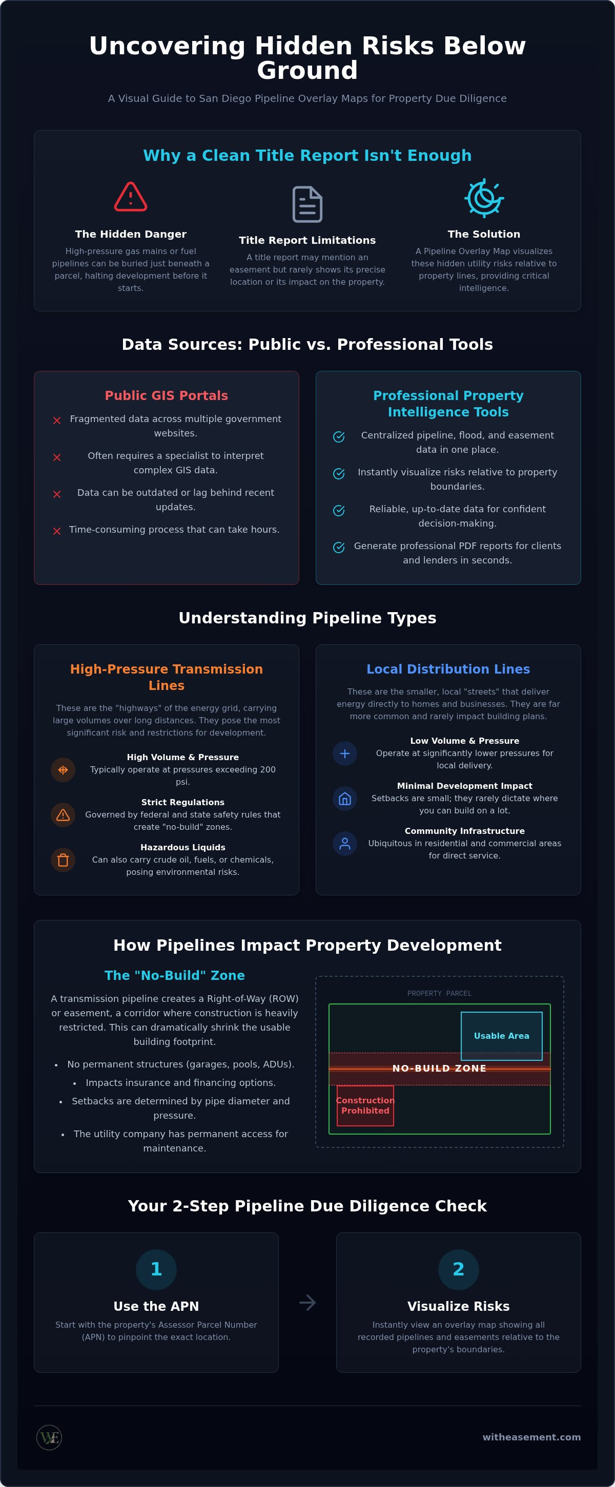
Pipelines create "no-build" zones that can significantly shrink a building footprint. You generally can't place permanent structures, like a garage, a pool, or an ADU, directly over a transmission line. Setbacks and safety buffers vary based on the pipe's diameter and operating pressure. Beyond physical limits, these easements can create hurdles for insurance and financing. Lenders may be wary of properties where a major utility easement reduces the usable acreage or creates perceived safety risks. Checking a San Diego pipeline overlay map early ensures you don't spend months on a design that's legally impossible to build.
Identifying Hidden Encumbrances Beyond Title Reports
Relying solely on title reports for utility data is a common mistake. A title report might mention that an easement exists, but it rarely provides a visual map of where that easement sits on the dirt. In some cases, older parcels may have legacy infrastructure or unrecorded utility agreements that aren't immediately obvious in standard county records. Overlays allow you to cross-reference legal descriptions with physical infrastructure data. This process helps you identify hidden encumbrances that could lead to expensive legal disputes or project delays after the deal closes.
A professional San Diego pipeline overlay map provides more than just a series of lines on a screen. It categorizes infrastructure by risk and utility type to give you a complete picture of a parcel's underground status. High-pressure natural gas transmission lines are the primary focus of most property intelligence reports. These lines operate at high volumes and require constant monitoring. Because of their significance, the U.S. Department of Transportation recommends that sellers disclose transmission pipeline easements during transactions to ensure full transparency and safety.
Hazardous liquid pipelines represent another critical data layer. These carry crude oil, refined fuels, or chemicals and present unique environmental risks compared to gas lines. Professional overlays also identify ancillary infrastructure that might not be obvious from the street. This includes shut-off valves, meter stations, and compressor sites. These surface-level features often require their own specific access rights and can impact the visual appeal or noise levels of a property. Understanding whether you're dealing with a standard easement or a fee-owned right-of-way is essential. In a fee-owned scenario, the utility company actually owns the strip of land, which creates a much stricter barrier for development than a simple easement.
Transmission vs. Distribution Lines
Transmission lines carry energy across long distances and require significantly larger setbacks than local distribution pipes. Map legends typically use color-coding or specific line weights to indicate pressure levels and pipe diameters. One critical data point is the Potential Impact Radius (PIR). This calculation determines the circular area around a pipeline where a failure could lead to significant consequences. Understanding the PIR helps developers assess the safety profile of a site before finalizing building plans or architectural layouts.
Historical and Abandoned Pipeline Records
Not every pipe shown on a map is active. "Orphaned" or abandoned lines often remain in the ground long after they've been decommissioned. While they no longer carry fuel, they can still create soil stability issues or complicate future excavation work. Professional overlays often include data on historical infrastructure to prevent surprises during the grading process. You can explore these specific layers and infrastructure markers by using a property easement search to get a complete view of any parcel's underground history.
Public Utility Maps vs. Professional Property Intelligence Tools
Accessing a San Diego pipeline overlay map through a public portal often feels like a step back in time. Most government-hosted GIS portals are designed for internal administrative use, not for the fast-paced needs of real estate professionals. They're often dry, intimidating, and plagued by high friction. Users frequently struggle with clunky interfaces that require specific browser plugins or manual address entries that don't always align with parcel boundaries. This friction creates a barrier to entry that can lead to skipped steps in the due diligence process.
Data lag is another significant hurdle with free databases. Public records are updated on a cycle that may not reflect the most recent infrastructure changes or decommissioning projects. When you're making a multi-million dollar decision, relying on data that's months or years old is a massive risk. Professional tools bridge this gap by aggregating data from multiple sources, providing a more current and reliable view of underground assets. They also allow for searching by Assessor Parcel Number (APN), which is far more accurate than searching by a street address alone.
The Limitations of Free Public Resources
Public maps often prioritize security over precision. To prevent unauthorized access or tampering, many free utility maps intentionally mask the exact location of high-pressure lines, offering only a general "buffer zone" instead of a specific path. This lack of detail makes it nearly impossible to determine if a pipeline clips the corner of a lot or runs directly through a planned building site. Additionally, exporting this data into a professional buyer report is usually a manual, time-consuming process. You're often left taking screenshots of low-resolution maps that lack the clarity needed for lenders or clients.
The Efficiency Gain of Centralized Platforms
The real power of modern intelligence lies in integration. Instead of jumping between three different websites to check for flood risks, HOA boundaries, and utility lines, you can use a San Diego interactive property map to see everything in a single, unified view. This centralization saves hours of tedious research and reduces the chance of missing a critical encumbrance. Professional platforms also offer AI-powered summaries that interpret complex map layers into plain English. You can generate a client-ready PDF report with a single click, providing immediate value and building trust. This level of automation transforms property research from a technical chore into a strategic advantage.
How to Perform a Pipeline Due Diligence Check
Performing a professional due diligence check requires a systematic approach to uncover hidden risks. Start by identifying the property using the Assessor Parcel Number (APN). This unique identifier ensures you're looking at the correct legal boundaries rather than a generic street address. Next, use a San Diego pipeline overlay map to visualize any underground transmission lines passing through or adjacent to the site. This immediate visualization is the only way to move from guesswork to professional intelligence.
Once the layers are active, measure the distance between the pipeline and your proposed building sites. This step is critical. It identifies potential violations of safety buffers or setback requirements before you commit to architectural plans. You must then cross-reference these findings with a San Diego property easement search. This allows you to verify the specific "Use" restrictions associated with the easement. Some agreements might allow for light landscaping; others forbid any surface modification whatsoever.
Keep in mind that digital maps are high-level tools. Publicly available pipeline maps can have an accuracy variance of up to 500 feet. This margin of error is why measuring distances digitally is only the beginning of your research. You need to verify the specific legal language in the recorded documents to understand your building rights and the utility's access requirements. To streamline this process, you can access our interactive pipeline overlays and generate a property report in seconds.
Verifying Easement Widths and Rights
The recorded easement document defines the physical width of the utility's access. While a map shows a line, the legal document specifies the actual strip of land impacted. Be on the lookout for blanket easements. These are older agreements that grant a utility company rights over an entire parcel rather than a specific, defined path. You also need to identify ingress and egress rights. These clauses allow utility crews to cross other parts of your land to reach the pipeline for maintenance, even if the pipe itself is on the edge of the lot.
Consulting with Professionals Post-Search
A digital search is a powerful first step, but it doesn't replace physical verification for complex projects. If your map search reveals a transmission line near a planned structure, call a land surveyor to mark the pipeline's physical location on the ground. Discuss these findings with a land-use attorney if you're planning a major development. You can also leverage AI for real estate due diligence to flag potential legal conflicts within complex documents. This tech-forward approach ensures you catch nuances that manual reviews might miss.
Streamlining Research with WithEasement Overlays
WithEasement transforms the way you approach due diligence by centralizing disparate data points into a single, intuitive platform. Instead of manual cross-referencing, you get a unified view of pipeline locations, flood risks, and HOA boundaries. This integration is designed for speed. By utilizing a San Diego pipeline overlay map within this ecosystem, you eliminate the need to navigate clunky government GIS portals. You gain an immediate understanding of how underground transmission lines interact with property boundaries, allowing you to identify potential deal-breakers in minutes rather than days.
The platform's true power lies in its ability to handle complex spatial data without requiring specialized training. It acts as a transparent facilitator between dense public records and your professional needs. You don't just see a line on a map; you see a comprehensive risk profile tailored to the specific parcel you're investigating. This effortless efficiency reduces the friction typically associated with land use research, empowering you to make data-driven decisions with confidence.
Instant Visualization for Real Estate Professionals
Navigating the interactive map is effortless. You can switch between different overlay layers with a single click to build a comprehensive risk profile. For example, you might overlay a high-pressure gas main with a flood zone to see how environmental and utility risks overlap. Searching by APN provides the highest level of accuracy, ensuring you're looking at the exact parcel records. Realtors use these visualizations to build trust with sophisticated buyers who demand transparency. When you can show a client exactly where a pipeline sits relative to their proposed building site, you position yourself as a tech-forward innovator and a reliable partner.
Generating Actionable Property Reports
Speed is nothing without clarity. WithEasement provides AI summaries that quickly interpret recorded encumbrances and easement language. These summaries translate dense legal descriptions into digestible fragments, so you don't have to be an attorney to understand a property's limitations. Once your research is complete, you can generate a professional PDF property report with one click. These reports are essential for sharing data with lenders, contractors, and clients. They prevent project delays by ensuring everyone has the same high-level intelligence from the start. You can customize these reports to focus on the data that matters most to your specific project, whether it's pipeline safety or flood insurance requirements.
Master Your Property Due Diligence
Successful real estate development depends on what you can't see from the street. A San Diego pipeline overlay map is the key to unlocking this hidden intelligence and protecting your building plans from unexpected utility encumbrances. By moving beyond basic title reports and clunky public portals, you gain the clarity needed to navigate complex easements with confidence. You've learned how transmission lines create strict no-build zones and why searching by APN is the most accurate way to verify property boundaries.
Centralizing this data is no longer a manual chore. WithEasement provides the tools you need to visualize risks, interpret records, and generate reports in seconds. You can access interactive maps with pipeline and flood overlays, backed by AI-powered property record summaries that do the heavy lifting for you. This professional approach ensures you never miss a critical detail during the due diligence period. It's about having the right data at the right time to make informed decisions.
Access comprehensive pipeline overlays and property reports with WithEasement and start building with total transparency. Your next project deserves the highest level of property intelligence.
Frequently Asked Questions
How do I find out if there is a gas pipeline on my property?
Use a professional property intelligence platform to view underground utility layers. You can search by address or APN to see if high-pressure transmission lines cross your parcel boundaries. While public maps exist, they often lack the precision you'll need for building plans. Always call 811 at least two working days before digging to have underground lines physically marked. It's a critical step that prevents damage and ensures site safety.
What is a pipeline overlay map and how is it used?
A pipeline overlay map is a GIS-based digital layer that displays the location of underground transmission infrastructure on top of parcel maps. Real estate professionals use these tools to identify potential encumbrances during the due diligence period. By visualizing a San Diego pipeline overlay map, you can see how gas or fuel lines interact with property lines. This helps you avoid restricted areas and plan safe building footprints relative to recorded utility rights.
Can I build a fence or structure over a pipeline easement?
You generally cannot build permanent structures, like garages or pools, over a pipeline easement. Utility companies require clear access for maintenance and emergency repairs. While some light landscaping or removable fencing might be permitted, you've got to verify the specific restrictions in the recorded easement document. Building without authorization can lead to legal action or the forced removal of the structure at your own expense. Always check the legal descriptions before starting.
Are pipeline locations public record in California?
Yes, pipeline locations are part of public record, but accessing them can be difficult. While the California Public Utilities Commission and local utilities provide basic viewers, these maps often lack the detail required for precise development. Professional platforms aggregate this public data into a single interface. It's easier to see how recorded infrastructure affects specific private property boundaries without navigating fragmented government websites or technical software that requires specialized training or expensive licenses.
What is the difference between a utility easement and a pipeline right-of-way?
A utility easement is a broad legal right for a company to use a portion of your land for services like power or water. A pipeline right-of-way is a specific type of easement that grants a utility company the right to install, operate, and maintain a transmission line. These rights-of-way often have stricter restrictions on surface use and building setbacks compared to standard utility easements for local distribution lines that serve individual homes.
How often are pipeline overlay maps updated?
Update frequencies vary depending on the data source and the utility provider. Public databases might only be updated on an annual cycle, which can lead to data lag. Professional property intelligence tools strive for more frequent updates by aggregating data from multiple authoritative sources. It is essential to use the most current data available to account for infrastructure decommissioning or new safety valve installations that could change the risk profile or development potential of a parcel.
Does a pipeline on a property affect its resale value?
A pipeline can affect resale value if it significantly limits the usable acreage or development potential of the land. Buyers may perceive safety risks or be deterred by the no-build zones created by the easement. However, providing a professional property report early in the transaction can mitigate concerns by offering transparent insights. Clear disclosure helps sophisticated buyers understand the exact impact on their future plans, turning a potential hurdle into a manageable fact.
How do I search for pipelines by APN?
Searching by Assessor Parcel Number is the most accurate way to find pipeline data. You'll enter the unique number into a professional property intelligence platform to pull up the specific parcel records. This method is superior to address searches because it links directly to the legal boundaries and recorded documents. You'll instantly see any pipeline overlays relative to that specific piece of dirt, ensuring a higher level of due diligence for your clients and lenders.


