

What if the map you just downloaded from a government portal is actually hiding the most critical information about your property? Most professionals assume a standard search for a parcel map with easements San Diego will reveal everything, but official GIS websites often bury recorded easements deep within complex layers. You've likely felt the frustration of hitting search limits or squinting at cryptic survey symbols that feel impossible to decode without specialized training.
It shouldn't take a surveyor's license to understand where a utility line runs or how a private access agreement affects a lot. This guide changes that. You'll learn how to master modern GIS tools and use AI-driven insights to locate, visualize, and interpret San Diego land records with total confidence. We'll walk through the process of bypassing clunky portals, identifying specific easement types, and generating professional reports that make your next permit application or client presentation a breeze. By the end of this professional guide, you'll have the tools to turn raw data into actionable property intelligence.
Key Takeaways
- Identify the Assessor's Parcel Map as your legal blueprint and learn how the APN acts as the master key to unlocking property data.
- Discover the exact steps to locate a parcel map with easements San Diego using street addresses or official portals without hitting common search limits.
- Decode complex survey symbols like P.U.E. and ingress/egress markers to understand exactly where utility and private rights affect the land.
- Learn why relying on outdated documents for construction is risky and why a "clean" map doesn't always mean a property is free of easements.
- Explore how to centralize San Diego land records, including AI-powered summaries and pipeline overlays, into one professional PDF report.
What is a San Diego Parcel Map with Easements?
A parcel map with easements San Diego serves as the definitive legal blueprint for any property within the county. Think of it as the DNA of a land parcel. It provides the visual layout of land divisions, highlighting how a specific lot sits within its neighborhood. At its core, every map revolves around the Assessor Parcel Number (APN). This unique string of digits acts as the master key; it unlocks specific data sets ranging from tax history to historical surveys. While a standard parcel map identifies land boundaries, a map with recorded easements includes specific overlays that designate where others have a right to use your land. A plat map is a scaled diagram showing these land divisions and their dimensions.
Understanding the Assessor's Parcel Map
The County Assessor uses these maps primarily for property tax valuation. They ensure every square foot of land is accounted for and assigned to the correct owner. However, it's vital to distinguish between lot lines and actual property boundaries. Lot lines on an assessor's map are administrative markers for tax purposes. A professional survey might reveal slight variations in physical boundaries that an administrative map won't show. Because of this high level of detail, these maps are the mandatory foundation for any San Diego property easement search. You simply can't accurately identify an encumbrance without first identifying the specific parcel it sits on. Using the APN allows you to filter through thousands of records to find the exact plat that matters to your project.
Identifying Easements on a Map
Locating a parcel map with easements San Diego requires an eye for detail. Look for dashed lines or specific abbreviations like P.U.E. (Public Utility Easement) or drainage symbols. These markers indicate that a third party, such as a utility company or a neighbor, has specific rights over that portion of the property. But What is an Easement? Essentially, it's a non-possessory right to use someone else's land for a specific purpose. It's a common trap to assume that if a map looks clean, no easements exist. Some easements are only mentioned in recorded deeds and never make it onto the visual map. This makes verifying hidden encumbrances critical before you start any development or purchase. Modern GIS tools now allow you to overlay these recorded documents directly onto the parcel map, giving you a 360-degree view of the property's legal landscape. Uncovering these details early prevents costly legal disputes or construction delays later on.
How to Find Parcel Maps with Easements in San Diego
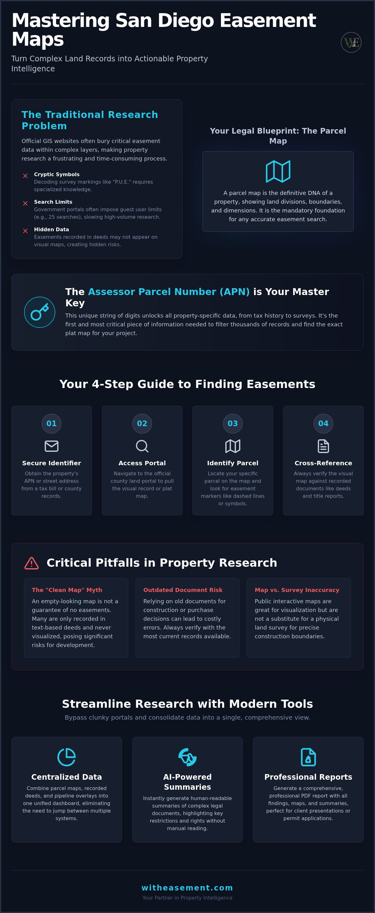
Locating a parcel map with easements San Diego requires a methodical, four-step approach to ensure you don't miss hidden legal encumbrances. Start by securing the property’s Assessor Parcel Number (APN) or street address. If you don't have the APN, you can find it on a recent property tax bill or via a basic search on official county land record websites. Once you have this identifier, access the local land portal to pull the visual record. After you locate the correct map page, identify your specific parcel number and lot boundaries. Finally, always cross-reference the visual map with recorded documents like deeds or title reports for a complete picture of all easements.
Navigating Official County Portals
Official online search tools are the primary gateway for most property research. They're efficient for a quick check, but they come with a hurdle for power users. As of 2026, many government portals typically maintain a 25-search limit for guest users. If you're conducting high-volume research for a real estate portfolio or a large-scale development, you'll need a professional workaround to maintain speed. To get the most authoritative documents, download the official plat maps directly from the public record repository. These documents provide the legal foundation for property identification and are essential for any permit application process.
Using Interactive Maps for Research
Interactive property maps allow you to toggle specific layers, such as parcel boundaries and known easement zones. These tools are excellent for visualizing how a property interacts with its surroundings. However, public map data has limitations in accuracy and should never replace a physical land survey for construction. For more technical data, use specialized survey record systems to extract specific bearings and historical data. If your research involves protected lands, you can also consult the California Conservation Easement Database to identify regional environmental restrictions that might impact your parcel.
Manually jumping between these different government portals can be exhausting and prone to error. You can bypass the friction of multiple logins and search limits by using a professional Property Easement Search tool. This allows you to centralize your research and generate clean, actionable reports in a fraction of the time it takes to navigate traditional administrative systems.
- Step 1: Gather your APN or address.
- Step 2: Open the local assessor or land record portal.
- Step 3: Locate the specific map page and parcel.
- Step 4: Verify the findings against recorded deeds.
Interpreting Map Symbols and Recorded Documents
A parcel map with easements San Diego is more than just a drawing; it's a coded language that defines land rights. To understand your property, you must first decode the shorthand used by surveyors and county officials. Common abbreviations tell the story of who can access your land and why. For example, P.U.E. stands for Public Utility Easement, while Ing/Egr signifies Ingress and Egress, which are rights for entry and exit. These markers are often accompanied by bearings and dimensions. A bearing like N 89° 50' 10" E indicates the precise compass direction of a property line, while numbers like 100.00' represent the distance in feet.
While the visual map identifies the location of an encumbrance, the recorded documents define its scope. These legal records describe the specific rights granted to the easement holder, such as the right to install underground pipes or maintain overhead wires. It's a common misconception that the lines on a map tell the whole story. In reality, an easement's width on a map may not reflect its full legal impact, as additional restrictions on building or landscaping often extend beyond the drawn boundary.
Utility vs. Private Easements
Identifying sewer, gas, and electrical lines is a standard step when using San Diego interactive property maps. Utility easements are typically straightforward, but private access easements are often the source of legal disputes between neighbors. These agreements can be decades old and might not appear clearly on modern digital layers without deep research. Adding pipeline overlays to your search is a professional necessity; they reveal high-pressure risks and infrastructure that standard parcel maps frequently omit. Understanding these layers prevents you from planning a structure over a critical utility corridor.
AI Summaries for Complex Records
Modern technology has removed the need to spend hours squinting at handwritten deeds from the 1950s. AI Summaries now translate dense legalese into actionable insights, highlighting the most critical encumbrances in seconds. Instead of guessing what a "grant of easement" means for your ADU project, you can get a clear breakdown of your limitations. This tech-forward approach transforms recorded deeds into simple property summaries, allowing you to make fast, accurate decisions during due diligence. You get the clarity of a professional report without the traditional wait times or high costs of manual interpretation.
- P.U.E.: Public Utility Easement for water, gas, or electric.
- Ing/Egr: Ingress and Egress for shared driveways or access.
- Bearings: Directional data (e.g., N 45° W) for property lines.
- Dimensions: The physical length of boundaries in feet.
Common Pitfalls in Traditional Property Research
Traditional property research often feels like a scavenger hunt where the prize is a legal liability. You might download a parcel map with easements San Diego from a public portal and assume it's the final word. It's not. Relying on outdated Assessor maps for construction is a recipe for disaster. These maps are administrative snapshots, not real-time engineering documents. A clean-looking map doesn't guarantee a property is free of encumbrances; many easements exist only in recorded deeds that haven't been digitized into visual layers yet. This gap between the drawing and the deed is where most project delays begin.
Real estate professionals often claim they can get this data for free from a title company. While title reports are essential, they are notoriously slow and lack interactive visualization. Waiting days for a preliminary report can kill a deal in a competitive market. Title companies also don't provide the interactive pipeline or flood overlays that show exactly how an easement cuts through a building site. You're left with a stack of confusing PDFs instead of a clear, visual strategy for land use.
Data Fragmentation and Search Limits
Checking a single source is never enough for professional due diligence. Real property intelligence requires cross-referencing the County Assessor, the Recorder's office, and environmental databases. This fragmentation creates massive friction. Official portals often impose a 25-search threshold that halts high-volume workflows for realtors and developers. If you need to verify a whole subdivision, you'll hit a digital wall. The costs of formal county reviews are also steep; a Parcel Map Review with the County of San Diego requires a $6,192 deposit as of 2026. Waiting for physical records to be mailed adds hidden costs in the form of project delays and lost opportunities.
Misinterpreting Boundaries and Setbacks
Reading parcel dimensions correctly is a specialized skill. A common mistake is confusing an easement with a setback requirement. An easement gives someone else a right to your land, while a setback is a zoning rule about how far a structure must be from the property line. Professional interpretation is vital because building an ADU or a fence in the wrong spot leads to expensive teardowns. You need to see the intersection of lot lines, utility corridors, and zoning rules simultaneously to avoid legal entanglements. This clarity is the difference between a successful build and a costly mistake.
Stop struggling with fragmented data and restrictive search caps. Start a WithEasement Membership today to access centralized records and professional PDF reports instantly.
Streamlining Research with WithEasement
Finding a parcel map with easements San Diego doesn't have to be a multi-day ordeal involving three different government agencies. WithEasement centralizes San Diego County land records into a single, intuitive platform. You get immediate access to recorded easements, HOA data, and critical environmental overlays without the typical administrative friction. This tool moves you from raw data to actionable property intelligence in seconds. It's designed to eliminate the guesswork that often plagues traditional land research.
Interactive Overlays and Risk Analysis
Visualize potential hazards before they become expensive problems. Toggle Flood Zone and Pipeline Overlays to see exactly where infrastructure and risks intersect with property lines. You can also skip the endless phone calls to local associations by accessing HOA management info directly through the platform. By leveraging AI for real estate due diligence, you save hours of manual research on every deal. These layers provide a level of clarity that standard GIS portals simply can't match. You see the whole story of the land on one screen.
Professional Reporting for Faster Closings
Transform complex data into clear, branded PDF Property Reports with just one click. These reports empower buyers with visual evidence of property encumbrances, making the disclosure process transparent and professional. Providing comprehensive data early in the transaction reduces your professional liability and builds trust with clients. It's a faster, more reliable way to reach the closing table without technical delays. You can present a parcel map with easements San Diego alongside risk data in a format that anyone can understand.
A WithEasement Membership is the ultimate competitive edge for high-performing realtors. It eliminates the search caps and fragmented workflows that slow down your business. You get the tools to perform a deep Property Easement Search and generate professional results instantly. This platform acts as your digital partner, handling the heavy lifting of land record organization so you can focus on closing deals. Efficiency is no longer a luxury; it's a standard part of your professional toolkit.
- Centralized Data: Access all San Diego land records in one place.
- Risk Visualization: Use overlays for pipelines and flood zones.
- Instant Reports: Generate professional PDF Property Reports in seconds.
- AI Summaries: Decode complex legal documents automatically.
Master Your Property Intelligence
Securing a parcel map with easements San Diego shouldn't feel like a hurdle in your professional workflow. You've learned that while official portals provide the raw data, true clarity comes from merging those maps with recorded documents and interactive risk overlays. Understanding the difference between administrative lot lines and legal boundaries ensures you avoid the common pitfalls that stall development. By automating the search for utility and private encumbrances, you protect your projects from costly legal disputes and construction delays.
It's time to move beyond fragmented government websites and restrictive search limits. You can now access AI-powered easement summaries and interactive San Diego map overlays in a single, centralized platform. Whether you need to visualize pipeline risks or use a professional PDF report generator for a client, the right tools put high-level data at your fingertips. Unlock professional property insights with a WithEasement Membership and take total control of your real estate due diligence. You're now equipped to turn complex land records into your greatest professional advantage.
Frequently Asked Questions
How do I find a parcel map for my San Diego property?
You can locate your map by entering the property address or Assessor Parcel Number (APN) into the County Assessor's online portal. These portals provide a visual layout of land divisions but often limit the number of searches you can perform daily. For a more professional experience, use a centralized platform that aggregates these records. This allows you to find a parcel map with easements San Diego without navigating multiple government interfaces or hitting search caps.
Are easements always shown on San Diego parcel maps?
Not necessarily. While many public utility easements are marked, private agreements or older historical easements might only exist in recorded deeds. These hidden encumbrances don't always appear on the visual plat map provided by the county. You must cross-reference the visual map with a search of recorded documents to ensure you have a complete legal picture of the property's restrictions before starting any development or purchase.
What is the difference between an Assessor's map and a survey map?
An Assessor's map is an administrative tool used primarily for property tax valuation and general parcel identification. It shows how land is divided but isn't precise enough for construction. A survey map is a high-accuracy engineering document prepared by a licensed professional. It defines exact boundaries, physical markers, and detailed dimensions. You'll need a survey map for building permits, whereas an Assessor's map is for general research and identification.
How can I look up easements by APN in San Diego County?
You can enter the unique APN into the County Assessor’s search tool to pull the basic plat map. To see the actual easements, you must then search the Recorder’s database for documents linked to that specific parcel number. Using a professional Property Easement Search tool simplifies this by linking the APN directly to recorded documents and interactive overlays. This saves you from manually hunting through disparate government databases for every deal.
Can I build over a utility easement shown on a parcel map?
Generally, building permanent structures like houses or ADUs over a utility easement is forbidden. Utility companies require clear access to maintain or repair underground lines and overhead wires. If you build over one, you may be forced to remove the structure at your own expense. Always verify the specific terms of the easement in the recorded deed to see if minor improvements, like fences or landscaping, are permitted on the land.
Where do I find recorded easement documents in San Diego?
Recorded easement documents are maintained by the County Recorder's office. You can visit the office in person or use their online index to search for historical deeds and grants. For a faster workflow, utilize a digital platform that offers instant access to these records. This allows you to download professional PDF property reports that summarize these complex legal documents into actionable insights without waiting for physical mail or visiting a government office.
What does 'P.U.E.' mean on a San Diego plat map?
P.U.E. stands for Public Utility Easement. This common shorthand indicates that a portion of the land is reserved for utility providers to install and maintain essential infrastructure. This can include water mains, sewer lines, gas pipes, or electrical equipment. When you see this on a parcel map with easements San Diego, it means you cannot build permanent structures in that designated area, though you still own the underlying land and property.
How much does it cost to get a professional property easement report?
The price for property intelligence depends on the level of detail and the speed you require. Official county reviews often involve significant deposits against staff time, which can be thousands of dollars. Alternatively, a membership model provides a cost-effective way for professionals to access data. This allows for high-volume searches and professional reporting for a predictable monthly fee, making it the preferred choice for active real estate workflows and due diligence.


