

What if a single string of numbers could reveal every hidden easement, HOA restriction, and flood risk attached to a piece of land? Most real estate professionals and homeowners treat an Assessor Parcel Number as a simple tax ID, but it's actually the most powerful tool in your arsenal. Conducting a San Diego County APN search for property data is the fastest way to uncover the legal story of a parcel. Since official online search procedures changed in late 2024, finding this information has become a significant hurdle involving in-person kiosks and confusing government portals.
You're likely tired of wasting hours manually cross-referencing parcel maps or paying for individual records that are nearly impossible to read. We understand how frustrating it feels when critical data is locked behind red tape. This guide will teach you how to master property research to get instant access to comprehensive records and professional PDF reports. You'll learn to visualize pipelines and flood zones clearly, ensuring you never miss a detail that could impact a property's value or use.
Key Takeaways
- Understand why the 10-digit APN is the most reliable key for legal research compared to standard street addresses.
- Learn how to perform a San Diego County APN search for property data to reveal zoning details, square footage, and accurate assessed values.
- Discover the exact steps to locate recorded easements and HOA restrictions that official county portals often hide behind paywalls.
- Compare the limitations of public kiosks with professional intelligence platforms to save hours on manual cross-referencing.
- Use AI-powered summaries to instantly extract critical risks like flood zones and pipeline overlays from dense legal documents.
The Role of APNs in San Diego County Real Estate
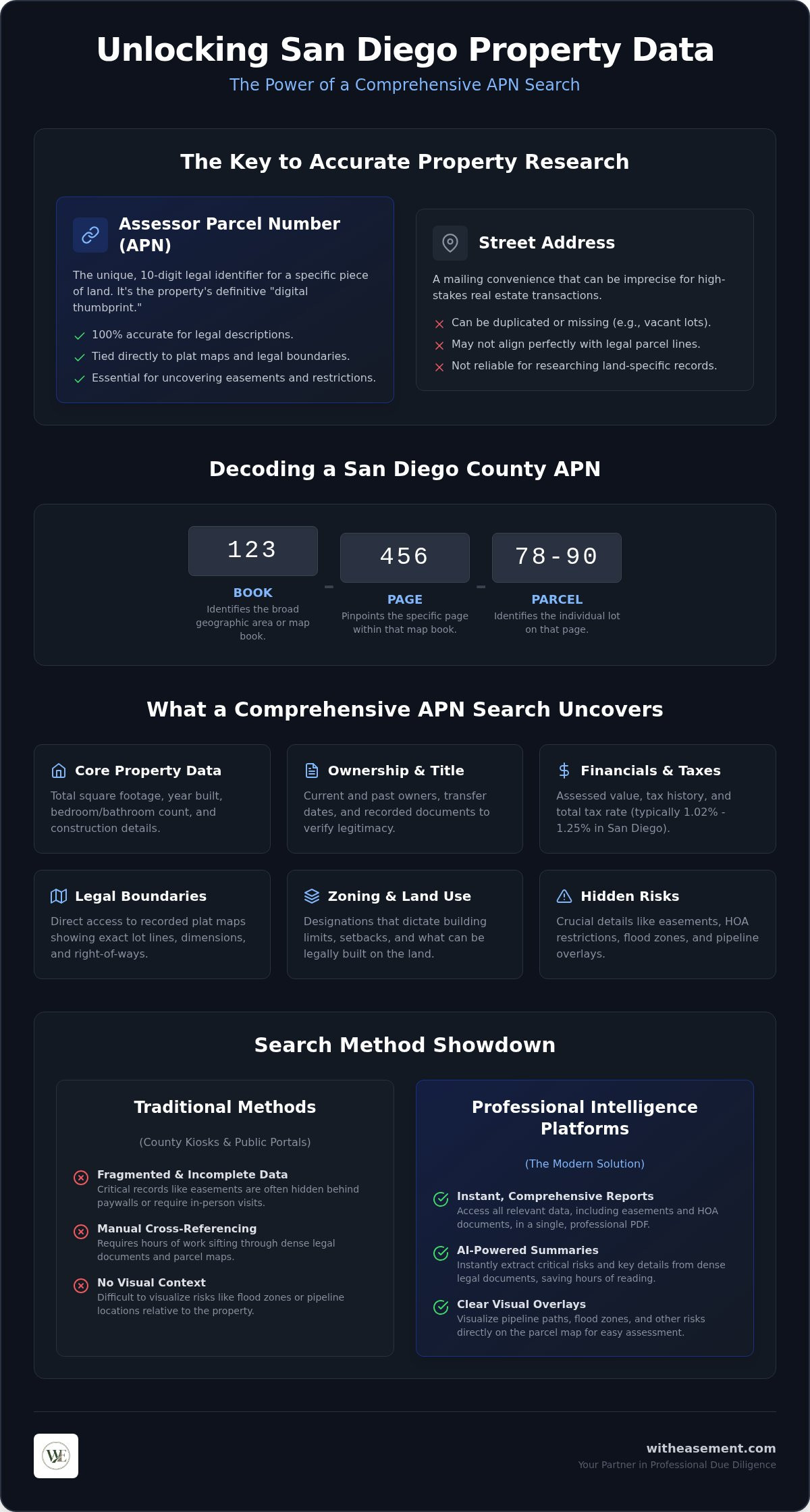
What is an Assessor's Parcel Number (APN)? It's a unique identifier assigned by the county to every specific piece of land. While a street address is useful for mail delivery, it's often too imprecise for high-stakes real estate transactions. The San Diego County Assessor uses this 10-digit code to track the entire life cycle of a property, including its ownership changes, annual tax history, and assessed value. It serves as the definitive digital thumbprint for a parcel, ensuring that data stays organized even when owners or street names change.
A San Diego County APN search for property data provides a direct link to the recorded plat map. These maps are the definitive legal blueprints for land. They show exact boundaries, right-of-ways, and the physical relationship between neighboring lots. Because addresses can be duplicated or missing in rural areas, the APN remains the only foolproof way to ensure you're researching the correct parcel. It's the starting point for any serious investigation into a property's history.
Understanding the 10-Digit APN Structure
The San Diego code isn't random. It follows a specific hierarchy that allows you to read a property's location at a glance:
- The Book (First 3 digits): Identifies the broad geographic area or map book.
- The Page (Next 3 digits): Pinpoints the specific page within that map book.
- The Parcel (Last 4 digits): Identifies the individual lot on that page.
Looking at sequential numbers is an easy way to find neighboring properties. If you see a sudden jump in the numbering or a specific suffix, it usually indicates a lot split or consolidation. When a developer divides a large ranch into smaller residential lots, the old APN is retired, and new numbers are issued to reflect the updated legal boundaries. This system ensures that every square inch of the county is accounted for without overlap.
Why Real Estate Professionals Start with an APN Search
Experienced agents and investors use the APN to eliminate ambiguity. A single building might have multiple street addresses, or a vacant lot might have no address at all. Starting with the parcel number ensures that the legal description in a purchase agreement is 100% accurate. It removes the guesswork that often leads to costly delays in escrow.
This process is also essential for a San Diego property easement search. Since easements are recorded against the land itself rather than the owner's name, the APN is the primary key used to unlock these records. It allows you to verify that no hidden utility lines or access rights will interfere with a client's development plans. Using a San Diego County APN search for property data turns a confusing pile of documents into a clear, actionable roadmap for professional due diligence.
Anatomy of a Parcel: What an APN Search Reveals
A San Diego County APN search for property data acts as a comprehensive deep dive into the physical and legal reality of a parcel. It moves far beyond a simple tax ID to reveal core characteristics like total square footage, the number of bedrooms, and the original year of construction. These details form the baseline for any property valuation or renovation plan. You can also track the ownership history and recent transfer dates to verify the seller's legitimacy and identify potential title issues early in the process.
The search also uncovers critical financial data. You will see the assessed value, which serves as the foundation for the property tax bill. In San Diego County, the base property tax rate is 1% of the assessed value, though voter-approved bonds and special assessments often bring the total rate to between 1.02% and 1.25%. With the median home value in the county reaching approximately $914,700, understanding these tax components is vital for calculating the long-term cost of ownership. It's important to distinguish this assessed value from the current market value, as Proposition 13 limits annual assessment increases to 2% unless a change in ownership occurs.
Zoning and Land Use Designations
Zoning designations determine what you can legally build on a specific parcel. These codes dictate everything from building height limits and setbacks to the allowed density of residential units. By analyzing the record history, you can identify non-conforming uses where existing structures might not meet current codes. This insight is essential for investors looking to expand or developers aiming to repurpose a lot. Understanding these designations helps you predict future property valuation and avoid purchasing land with hidden development restrictions.
Environmental and Infrastructure Overlays
Modern due diligence requires looking at environmental risks that aren't visible during a walk-through. A thorough search identifies wildfire risks and flood zones based on the latest FEMA data. You can also locate high-pressure gas lines and other utility infrastructure that might cross the property. Utilizing a San Diego interactive property map allows you to visualize these risks in real-time. Instead of digging through hundreds of pages, you can see exactly where a pipeline or flood zone intersects with your lot boundaries. For a more streamlined experience, you can access professional PDF property reports that consolidate all these findings into a single, client-ready document.
Official Portals vs. Professional Intelligence Platforms
The landscape for property research changed significantly in late 2024. Under California Assembly Bill 1785, public online searches by APN were discontinued. Today, a traditional San Diego County APN search for property data through the Assessor/Recorder/County Clerk (ARCC) usually requires a physical visit to a county office kiosk. While these official portals remain the source of truth, they aren't designed for speed or clarity. Users often face an "Interpretation Gap" where they have access to raw images of deeds but no easy way to synthesize that information into a professional risk assessment.
Manual research also carries hidden financial costs. Official portals often operate on a pay-per-document model. When you consider the $14 base recording fee and the $75 Senate Bill 2 fee for certain documents, the price of gathering a full property history can climb quickly. Professional platforms offer a more predictable cost structure through membership access, allowing you to pull multiple records without worrying about individual transaction fees for every page.
The Reality of Manual Property Research
Efficiency is the primary victim of manual research. You might find yourself checking three different portals just to understand one property. You'll visit the Assessor's site for value, the Recorder's office for easements, and separate environmental sites for flood risk. This fragmented approach is incredibly inefficient and increases the risk of missing a critical recorded easement buried in an unorganized list of hundreds of documents. For time-sensitive real estate deals, waiting in line at a kiosk or navigating clunky government interfaces can stall your progress indefinitely.
The Advantage of Centralized Data Platforms
Centralized platforms eliminate this friction by aggregating disparate data into a single, interactive view. Instead of visiting multiple websites, you get a consolidated look at easements, HOA data, and flood maps tied directly to the parcel number. Using AI for real estate due diligence San Diego allows you to parse through dense legal language in seconds. These tools do the heavy lifting of organizing information so you don't have to. You can generate professional, client-ready PDF reports that visualize pipeline overlays and flood risks instantly. This shift from raw data to actionable intelligence empowers you to make faster, more confident decisions without the administrative headache.
Step-by-Step Guide to Finding Easements and HOA Data
Locating the 10-digit APN is your first step toward a successful due diligence workflow. If you only have a street address, start with an interactive map to pinpoint the exact parcel. Once you have the number, use it to filter the county's grantor/grantee index. Running a San Diego County APN search for property data allows you to bypass thousands of irrelevant records and focus on documents that directly affect the land's title and usage rights.
Identifying Hidden Easements
Easements often hide within dense legal descriptions. They aren't always labeled clearly in a basic title summary, which can lead to expensive mistakes during construction. You must distinguish between utility, access, and private easements to understand their impact on land use. Look for specific recording numbers associated with easement deeds in the parcel history. These numbers lead you to the original grant, which defines the exact rights held by third parties like San Diego Gas & Electric or neighboring owners.
Every buyer should know what to look for in HOA documents San Diego to avoid restrictions that could block future improvements. Cross-referencing the plat map with physical property boundaries is also essential. It ensures that city sewer lines or shared access paths don't encroach on your planned buildable area. Seeing these lines on a professional map is far more effective than trying to interpret a complex metes-and-bounds description by hand.
HOA and Management Discovery
Finding the right contact for a Homeowners Association is a common roadblock for realtors and investors. HOA management information is usually linked to the parcel through recorded Covenants, Conditions, and Restrictions (CC&Rs) and their subsequent amendments. Use a streamlined search tool to identify the current management company and verify the property's status. This step helps you uncover potential liens or unpaid assessments that might stall a closing or create unexpected liabilities.
Accessing the bylaws and CC&Rs early gives you a clear picture of architectural restrictions and monthly dues. These documents are legally binding and run with the land, meaning they are tied directly to the parcel number. A San Diego County APN search for property data is the most efficient way to verify these details before you commit to a deal. If you want to save time and avoid the frustration of manual record hunting, you can order a comprehensive HOA search to get all governing documents and contact details in one professional report.
Enhancing Due Diligence with AI-Powered Property Summaries
A comprehensive San Diego County APN search for property data often results in a mountain of digital paperwork. It's common to find yourself staring at 50-page property reports filled with dense legal jargon and archaic land descriptions. While the data is all there, the sheer volume makes it easy to miss a critical detail. AI-powered summaries solve this problem by acting as a filter, extracting the most important risks so you can focus on the big picture. This technology transforms raw public records into a clear, standardized story for every parcel.
Standardizing your due diligence process ensures that every member of your real estate team looks at the same high-quality data. By automating the extraction of easements, flood zones, and HOA restrictions, you eliminate the variability of human error. This systematic approach allows you to move from initial interest to a final decision with much higher confidence. It's no longer about just finding the data; it's about making that data work for you in a fast-paced market.
Instant Interpretation of Complex Records
AI doesn't just read the documents; it interprets them. It can take a complex easement deed and summarize it into actionable bullet points. This allows you to quickly identify red flag easements that might block a pool installation or a guest house construction. Instead of spending hours reading every line of a title history, you get an immediate overview of potential deal-breakers. This speed is essential when you're managing multiple transactions at once and need to provide quick answers to clients or partners.
Generating Professional Deliverables
Transparency is the foundation of trust in real estate. Branded PDF reports allow you to share your findings with buyers or investors in a format that's easy to understand. These reports combine high-level data summaries with visual map overlays, showing exactly where pipelines or flood risks sit on the property. Providing this level of detail upfront makes you look like the expert you are. It removes the mystery from the property's history and gives everyone involved the clarity they need to proceed. You can start your San Diego County APN search with WithEasement today to unlock these professional insights instantly.
Master Your Property Due Diligence
Mastering your property research starts with recognizing that an APN is the most reliable key to a parcel's history. You've learned how this 10-digit code unlocks critical details about zoning, ownership, and hidden legal encumbrances. Conducting a San Diego County APN search for property data shouldn't involve hours of manual cross-referencing or frustrating trips to government kiosks. By using modern tools, you can bypass the interpretation gap and get straight to the facts that matter most for your transaction.
It's time to stop digging through dense legal jargon and start using data that works for you. You can easily visualize flood zones and pipelines while generating branded reports that build immediate trust with your clients. Unlock Professional Property Intelligence with WithEasement to access AI-powered property record summaries, interactive easement and pipeline maps, and professional PDF reports for realtors. Take the guesswork out of your due diligence and move forward with the clarity your business deserves. Success in San Diego real estate is built on accurate information; start your journey today.
Frequently Asked Questions
How do I find a San Diego County APN by property address?
To find an APN by address, use the online search tools provided by the County Assessor or professional property platforms. Simply enter the full street number and name to generate the associated 10-digit code. While searching by APN is restricted online, searching by address remains accessible to the public. This allows you to identify the correct parcel before diving deeper into recorded documents or environmental risk overlays.
Is a San Diego County APN search free for the public?
Basic in-person research at county kiosks is free. However, since late 2024, online APN-based searches are restricted for public use under California Assembly Bill 1785. You can still view some address-based data online for free, but detailed records and certified copies often require payment. Professional platforms provide a more efficient alternative to physical visits, offering comprehensive data access through a membership model that saves time and travel costs.
What is the difference between a parcel map and a plat map?
A plat map is a document showing how a large tract of land is divided into smaller lots. It establishes the legal framework for the entire subdivision. A parcel map is used for smaller divisions, typically four or fewer lots. Both maps are essential when performing a San Diego County APN search for property data. They provide the visual context needed to understand property boundaries, right-of-ways, and the location of neighboring parcels.
Can an APN search show me if a property is in a flood zone?
Yes, an APN search can reveal flood risks when integrated with FEMA data. Modern property intelligence platforms overlay flood insurance rate maps directly onto the parcel boundaries. This allows you to see if a property sits within a high-risk 100-year flood zone or a moderate-risk 500-year zone. Identifying these risks early is crucial for determining insurance costs and understanding potential building restrictions that could impact the land's overall value and utility.
How do I find out who the HOA manager is for a specific APN?
You can identify the HOA manager by searching the recorded CC&Rs and subsequent amendments linked to the parcel number. These documents are public records and usually name the association or management firm in charge. Streamlined search tools aggregate this data, providing direct contact information for HOA managers. This helps you quickly verify current dues, check for outstanding liens, and access governing bylaws without the frustration of manual record hunting or cold-calling.
Are recorded easements always visible on a parcel map?
No, recorded easements are not always visible on a standard parcel map. While maps often show public utility right-of-ways, private access or specific utility easements might only be detailed in the written legal description of a deed. To find these, you must search the county's grantor/grantee index using the APN. This step is vital to uncover hidden encumbrances that could legally restrict where you can build structures, fences, or other improvements.
What happens if the APN on my tax bill doesn't match the deed?
If your tax bill APN doesn't match your deed, it usually signals a recent lot split or a clerical error. Contact the Assessor's office immediately to clarify which number is current. Relying on an outdated identifier for a San Diego County APN search for property data can lead to inaccurate results regarding ownership or liens. Always verify the number against the most recently recorded grant deed to ensure you are researching the correct legal entity.
How often does San Diego County update its parcel data?
San Diego County updates its ownership and parcel data continuously as new deeds and maps are recorded. However, digital systems might show a delay of a few weeks between the physical recording and the online update. Assessed values are typically refreshed once a year for the annual tax roll. Professional data platforms often aggregate these updates more frequently, providing realtors and investors with the most current intelligence available for time-sensitive real estate decisions.


